|
Meanest Lessons Live On.
by Jaime Capell - Algonquin Outfitters, Oxtongue Lake

Up until the meanest link I had never carried a canoe for more then a hundred meters in my life. Somehow I had always gotten someone else to do it on trips. I was generally a pack mule. The idea of carrying a canoe was too much. It was so awkward, so painful, and so heavy I couldn't do it. In fact I wouldn't try. I remember telling the other girls I was doing the Meanest Link with that I would not carry a canoe alone. It would not happen. I would carry it with my partner, but never on my own. Well, it became apparent on the very first portage that the height difference between my self and my partner was too great, and to my total dismay I would be carrying a canoe after all.

I bonded with that Royalex MadRiver 15 over our fourteen day trip. That pipe-smoking rabbit egged on my every step. Sure, I dragged it for a bit on a particularly long portage, but it also tried to kill me on more then one slippery boardwalk, trying to take off my head as I crashed into the bushes. But I realized that I loved carrying a canoe! It was balanced. A successful flip-up was like a pat on the back and man, a gal with a canoe on her head; what a profile! I discovered I could do it and I actually liked it.
 The Meanest link challenged me more then any trip I had done before. It still stands out for me as an event that changed me as a person. That sounds far fetched, but I learned a lot about myself and I pushed a lot of personal boundaries. I don't think a person has to do the Meanest Link to enjoy the afterglow of a personal trip best, although the link does make for an excellent story. There are lots of routes in Algonquin Park that are challenging and attainable. A good canoe trip is about discovery. It encourages resourcefulness, creativity and helps build better relationships. For me the Meanest Link did all of those things. It is a trip I will never forget. The Meanest link challenged me more then any trip I had done before. It still stands out for me as an event that changed me as a person. That sounds far fetched, but I learned a lot about myself and I pushed a lot of personal boundaries. I don't think a person has to do the Meanest Link to enjoy the afterglow of a personal trip best, although the link does make for an excellent story. There are lots of routes in Algonquin Park that are challenging and attainable. A good canoe trip is about discovery. It encourages resourcefulness, creativity and helps build better relationships. For me the Meanest Link did all of those things. It is a trip I will never forget.

For more information on the Meanest Link Canoe Route: |
|
Friends of Algonquin Map
 The classic Algonquin Park Canoe Route map gets a fresh new look for 2012. Park Staff working in Algonquin's back country have had their hand in updating the Friend's of Algonquin Park's Official Map which illustrates canoe routes, campsites, portages, lakes, access points and much more. The classic Algonquin Park Canoe Route map gets a fresh new look for 2012. Park Staff working in Algonquin's back country have had their hand in updating the Friend's of Algonquin Park's Official Map which illustrates canoe routes, campsites, portages, lakes, access points and much more.
Important trip planning information such as how to plan your route, what equipment to bring, plus rules and regulations and how to reserve are also available.
This is a great map for the first time user or someone looking for simple to read map information. This map also retails for just $4.95 and 100% of the proceeds from your map purchase supports Algonquin Park.
This is also the first year that you've been able to explore the map online. We applaud the Friends for putting the map on their website where everyone can easily find and explore it.
 View online: www.algonquinpark.on.ca View online: www.algonquinpark.on.ca
|
Jerrrey's Algonquin Map
Algonquin Outfitters has featured and carried Jeffrey's Map ever since it was only available online in it's digital version. This map clearly packs the most information into any map of Algonquin Park available today. Jeffrey has updated so many features on his map we're going to just focus on the many updates:
- New Beautiful colours. I spent 3 months redoing the colour scheme to make the map more readable & accessible than ever.
- I correct the lengths of mismeasured portages. The signed lengths are also shown in smaller text so that there's no confusion.
- Spot heights are now shown
- Rapids have classifications labelled where known
- Hunting cabins are now shown
- Parkbus stops are now shown
- Fish sanctuaries are now noted
- Bunched up campsites are clearly labelled now
- Provincially significant wetlands are now noted
- Old growth is now shown outside Algonquin
- Crown land/private land data is much more accurate, including the private land indications inside Algonquin. Also, rather than shading private land like I previously did, I now shade crown land to reduce confusion
- And of course more campsites and portages have been GPSed, more corrections from my observations + the observations of other Algonquin enthusiasts, more fishing data, more data from historic maps, more crown land campsites, more access points and more hiking trails
Jeffrey's also introduced a new folded waterproof version of his map for 2012 which is already available in our stores right now for just $14.98 each.
- Waterproof, tear resistant and they float.
- Crisper text and clearer symbols than ever before. Being professionally produced, the print quality is impeccable.
- They're split in to four sections for ease of handling, but there's a large amount of overlap between sections so that most people will only need a single section for a trip!
- Really extensive and useful content on the back of the map. It's designed to be as practical as possible and includes sections on how to estimate portage difficulty, how to avoid noise, things to explore, building a campfire, satellite viewing, and fish and wildlife
- Only 85 grams light
- For those using a compass with the map, magnetic, grid and true north are now listed
- It's really zoomed in for ease of reading (1:84 000)
 Explore & download the map online: www.algonquinmap.com |
| Clark Geomatrics Map
The Algonquin Park - Highway 60 Corridor Recreation Map - is the latest map from Clark  Geomatics. It's an exceptional 1:75,000 scale map created for paddlers, hikers and campers alike. This two-sided map is beautifully detailed, GPS-ready and filled with canoe routes, hiking and biking trails, as well as planning information (for example, the unique Park Activity Calendar). Geomatics. It's an exceptional 1:75,000 scale map created for paddlers, hikers and campers alike. This two-sided map is beautifully detailed, GPS-ready and filled with canoe routes, hiking and biking trails, as well as planning information (for example, the unique Park Activity Calendar).
Anyone heading to Algonquin will enjoy this one-of-a-kind map as it offers the most accurate and up-to-date access and route information available and is sure to enhance your outdoor experience.
Clark Geomatrics
Website / Explore the Map
|
Chrismar Adventure Maps
Mark and Christine are excited about 2012, as a bunch of guides they've been working on for several years are due to be published. Canada's only maker of original wilderness recreation maps - they create all the map data from scratch using sophisticated aerial photogrammetric techniques - each guide is a real work of science, art, research and outdoor adventure. They have been paddling and hiking since April exploring and surveying the variety of different areas being made into new Adventure Maps®.
 Already they've released several updates of existing maps (most of their popular maps are updated every two years or so), and a new western Canadian map was released in January - if you like backcountry alpine skiing and snowboarding then you'll find their new Glacier National Park winter map to your liking. Other map guides intended for release later this summer;i Mississagi River, Kawartha Highlands, Missinaibi River 3, Parry Sound/Killbear, but for Algonquin enthusiasts the last in their main series will be of particular interest - the Algonquin 5 - South Central is approaching completion and will cover the area just west of Opeongo including Shirley, Booth, and McKaskill lakes.

|
|
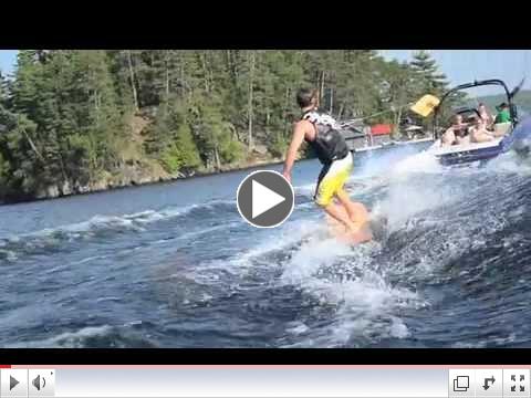
Muskoka Surfboards
Growing from roots in Dwight and Baysville, the Muskoka Surfboard Co. has emerged as a unique cottage country product to amp up the fun on the water this summer. Producing aand shaped, all wood, towable surfboard for use behind regular ski or aluminum boats, personal watercraft or pontoon boats.
 | | The Muskoka Surfboard Co. |
Hang it on your wall because you can appreciate the hand crafted feel and look of a time gone bye. Spend the day with your friends surfing the wake behind your boat as the sun sets over your lake. Rub it with oil and wax like you would treat a classic automobile.
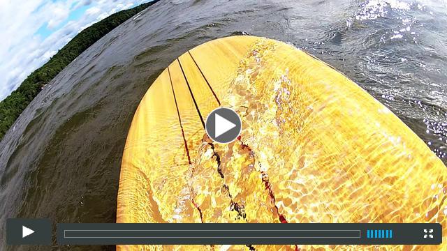 | | Kite Surfing with Muskoka Surfboard |
Video produced locally by Matt Kerr:
"My cousin Luke and I headed out to catch some footage of him riding a board from MuskokaSurfboard.com. Great times! Nice board!
The footage was shot near Huntsville with a GoPro HDHero2 camera ... pick it up locally at Algonquin Outfitters"
 Length: 6ft Length: 6ft - Width: 18"
- Thickness: 3/4"
- Weight: 15 lbs
- Profile: Parabolic, concave bottom, blended bottom to top nose.
- Rail: Hand bevelled with gentle side to side rocker.
|
Roxy SUP night in Huntsville Algonquin Outfitters Surf Department, Swifty's Surf & Snow will be hosting a Roxy SUP evening Thursday July 5th form 5-7pm. Registration for this on the water event will open soon with a cost of $25 each, space is limited to just 12 girls. For this price you receive; from Roxy a bag of goodies with a retail value of $50+, save 20% off Roxy just for showing up and an evening of Stand Up Paddleboard instruction on the water. 
|
Mobile App of the Month
Since we are on the topic of Maps this month I though I would share with you a map APP that's been on my phone ever since the first week I got my iPhone.  Topographic Maps Canada Topographic Maps Canada is another great free app that every outdoor adventurer should have on their iPhone. It allows you to download and view topographic maps of Canada. Although not as detailed as the maps we've covered in this newsletter Topo maps are still the global map standard. Topographic maps are useful for recreational activities such as hiking, canoeing, camping, fishing, mountain biking, and exploring. - Download from a collection of thousands of detailed topographic maps covering most of Canada.
- The downloaded maps can be viewed when you are not connected to the Internet.
- Use location tracking to show where you are on a map.
- Measure the distance between two or more places on a map.
- Add waypoints to a map to mark specific locations.
- Import and export GPX files containing waypoints.
 Download this Free App from iTunes today Download this Free App from iTunes today
Flash back to our March 2012 newsletter when we covered the Photosynth App by Microsoft. Recently I watched a TED Talk video that included an interview with Blaise Aguera y Arcas (Watch Video) |
 Let's Get Social Let's Get Social 
|
|
|
|
 Centennial Ridges - Feature Algonquin Trail Centennial Ridges - Feature Algonquin Trail
 If you were to ask me on any given day where I would chose to go for a hike in Algonquin Park, more often then not I would answer, "the Centennial Ridges hiking trail." Why is this trail a sparkling gem in an overflowing treasure chest of natural wonders? There are three qualities that make Centennial Ridges my destination of the month. The first quality that draws me to this 10 km hiking trail is the length and difficulty of the trail. With a total elevation gain of approximately 400 metres, this trail really shakes the rust off the leg muscles. The by-product of hiking a more difficult trail is that there are fewer people and subsequently a more peaceful Algonquin experience. That is my second reason for picking Centennial ridges as the destination of the month. As much as I enjoy hiking a short easy trail with a great view, I personally prefer not to be stuck in stop and go foot traffic. This type of hiking can sometimes lead to "trail rage." Indicators of trail rage include; rolling of the eyes, mumbling under one's breath, deep sighs, and sarcastic comments regarding the slow pace of the group ahead. The final quality of Centennial Ridges that makes it my top destination are the stunning panoramic viewpoints. Words cannot describe the feeling you get when you reach one of the spectacular bluffs overlooking hundreds of square kilometers of beautiful Algonquin Park wilderness. Click the image below to explore Centennial Ridges in Google Maps   The Centennial Ridges Trail is located at Km 37.6 on Hwy 60 in Algonquin Park. A day use permit is required. For more information see: www.algonquinpark.on.ca
|
 | | View our event calendar |
June & July2012 Events
|
|
Special offer just for our newsletter subscribers
|

|
Free Grey Owl Kayaking Paddles*
Earlier this spring we received a truck load of Grey Owl Paddles. We bough so many Grey Owl Kayak Paddles we've got a huge over stock of them now. To solve this dilemma we are offering a 2 for 1 deal on any in stock Grey Owl kayak paddles. * - Buy any in stock regularly priced Grey Owl wooden, fiberglass or even carbon kayak paddle and get a second paddle of equal or lesser value for FREE! Save up to $330 when you get a 2nd paddle for FREE! Not valid with any other offer. PRESENT THIS COUPON AT TIME OF PURCHASEAO Coupon Sku: 1277154
| Valid: June 15th until July 15th 2012 / www.algonquinoutfitters.com / 1-800-469-4948
|
|
|
|


