| Low Tide 2:56am | High Tide 8:49am | Low Tide 3:44pm | High Tide 9:26pm* |
|
|
| Be part of the discussion. | 
*
|
|
WW follow-up
| Corrections, clarifications, updates and letters to the editor
 The Shallowing
To the editor, Lots of smart people came to the post-Sandy "General Assembly" hosted by MWA on November 14, and after a short panel discussion we split up into the requisite working groups, where lots of smart stuff got said. But for me, at least, the highlight--an actual piece of fresh information!--came during the opening remarks of one of the panelists, Philip Orton. A research scientist at Stevens Institute and perhaps the leading local authority on storm surges (check out his blog here), Orton described a Stevens study in which the shipping channels in Jamaica Bay-currently at about 20 feet-were hypothetically filled in. What the modeling showed, he said, was that an intentional "shallowing'" of the channels could reduce storm tides (and thus, flood elevations) along the Bay's edges by significant amounts. Orton acknowledged the importance of the channels-they are used by the DEP 'sludge ships' that carry bio-solids from the four wastewater treatment plants that discharge into the Bay. Nevertheless, he said, it might be worth considering the shallowing idea, even if it meant developing alternate strategies for transporting the sludge. Later, I asked Orton whether Stevens had done any similar modeling of the much deeper channels in the Upper Harbor, and the kind of impact they might have had on the surge there. It would be very interesting, for example, to know how much more surge Red Hook, Lower Manhattan, and Hoboken had gotten as a result of our reshaping the bottom of the harbor, and how much those last few feet of surge-presumably the most expensive--had cost. Orton said Stevens had not done any such modeling, but added that it wouldn't be hard-and was perhaps something that his team could get to later in the winter, once their initial round of post-storm assessment was done. Among the big ideas that have been floated since the storm, the most prominent is the creation of a network of colossal storm-surge barriers or sea gates. Mayor Bloomberg has expressed skepticism about that, but Speaker Quinn and Senator Schumer have jumped on the bandwagon and, while not quite endorsing the idea, called for a multi-million-dollar Army Corps study of the concept. Groups like the Regional Plan Association and even MWA seem to think the study is a good idea too, and so perhaps that is what we are going to do. But if Sandy really is an opportunity to "rethink" the relationship of the city and the harbor, another option that ought to be on the table-which is to say, another option we ought to spend some real money on studying--is the idea of 'unbuilding,' or letting the place revert to what it naturally wants to be: a shallower harbor and a greener estuary protected by an ever-shifting set of barrier islands. This is not to suggest that we fill in our major shipping channels or start pulling out useful bulkheads and piers-our local economy, as it's currently configured, depends on those things. But we ought to at least try to take an honest look at what development above, in, and under the water has--and will--cost us, and use those numbers to plan for a different, more sustainable future. It could mean surrendering some big and commercially valuable stretches of the waterfront and the bay bottom. It could also be the only solution we can afford. Rob Buchanan Co-founder of the Village Community Boathouse, the Brooklyn Bridge Park Boathouse and the NYC Water Trail Association, and the New York co-chair of the Citizens Advisory Committee to the EPA's Harbor & Estuary Program |
Events on the Waterfront
|
|

For a map of vessels navigating the NY/NJ waterways at this moment, check marinetraffic.com.
Tide times above are for the waters off Port Ivory, Howland Hook on November 30, 2012. For your waterfront's daily tides, go to saltwatertides.com.
For information about environmental conditions (currents, water temperature, salinity, wave height, etc.) of the New York Harbor area, check the Urban Ocean Observatory at Stevens Institute's Center for Maritime Systems
|
|
|
| CONTENTS: November 30, 2012 |
Click on the links below to read the stories in this edition of WaterWire.
Clean-Up Round-Up
Reports from all around the metro region on storm recovery
Newslinks
|
CLEAN-UP ROUND-UP
| | Post-Sandy Reports From Around the Region
A month after Superstorm Sandy churned through the metropolitan area, the piles of sodden debris are beginning to get smaller. Outside New York City, wastewater treatment facilities are struggling with repairs, particularly on Long Island and in New Jersey. Many people are still homeless; many businesses are nonviable; many waterfront parks and public places remain closed. The Metropolitan Waterfront Alliance hails the thousands of people -- many of our partners among them -- who have contributed time, energy, money, food and clothing to those in need. Below are snapshots of waterfront relief work over the past couple of weeks. THE ROCKAWAYS AND FRESH KILLS
The debris mountain at Jacob Riis Park was the biggest in the city, but, thankfully, it's diminishing. "More is going out at this point than is going in," said Jeff Hawk, public affairs officer for the Army Corps of Engineers. The NYC Department of Sanitation, assisted by the Army Corps and the Environmental Protection Agency -- which sent workers to pick through the debris for hazardous material like electrical appliances -- is trucking material to the Fresh Kills landfill on Staten Island. At Fresh Kills, it's loaded onto barges on the Arthur Kill and sent up the Hudson River by tug to a landfill near Albany. More than 26,000 tons of debris has been sent out of the city in this way. 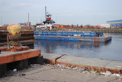 A barge carrying debris from last month's Hurricane Sandy,
leaves Fresh Kills on its way to the Port of Coeymans via
the Hudson River on November 18. Photo by Brandon Beach/USACE
Early in the debris management after the storm, the Army Corps considered express construction of a dock at Riis Park, so that barges could pull in directly for loads. But, "by the time we get barging set up, it may not be cost-effective to use it," Mr. Hawk told WaterWire earlier this week. Meanwhile, the Rockaway Waterfront Alliance is galvanized, inviting volunteers to help sweep the streets at its clean-up and information events on Sundays at Firehouse 59, and promoting the re: Rockaway Project, which will guide the rebuilding of the community to be more environmentally resilient. Executive director Jeanne DuPont is grateful for the outpouring of help. "These past few weeks I have met people from all over the country who have traveled to the Rockaways to help distribute food, cook warm meals and help to dig out homes and businesses in order to get people back on their feet," she wrote in an email to supporters. STATEN ISLAND
Gradually, boats are being transferred by crane back to the marinas at Great Kills Harbor from their storm-tossed resting places on streets and lawns. But lives in this waterfront enclave and other devastated Staten Island neighborhoods -- South Beach, Tottenville, Midland Beach and others -- will never be the same. See this NY1 report and this Gothamist report for more. 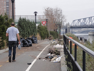 HARLEM RIVER PARK
On the Manhattan side of the Harlem River, NYC Parks Dept. employees gathered with Harlem River Park Task Force folks to fill bags with debris from the shoreline. At right, park designer Ricardo Hinkle works at the shoreline. Photo by Thomas Lunke
GATEWAY NATIONAL RECREATION AREA
Closed at the evacuation notice on October 28, Gateway National Recreation Area has been partially reopened by the National Park Service. "An amazing team of personnel assembled from NPS sites across the country has been working on the recovery and rehabilitation of the park properties with the primary goal of establishing the safety of all park employees and visitors," wrote NPS editor Charles Markis in his notice alerting subscribers that Jamaica Bay Wildlife Refuge and Great Kills Park would reopen on November 23. LIBERTY STATE PARK
More than 400 volunteers showed up to work at Liberty State Park in Jersey City on November 17, where 40% of the pavers were gone and the ferry docks were wrecked. "People made a great difference in this first public participation effort to restore LSP," wrote Sam Pesin, president of the Friends of Liberty State Park, in a mass email. It was a great start to restoring the park, but there's much still to do. Superintendent Rob Rodriguez said a full restoration of the park could cost $10 million. RED HOOK
David Sharps of the Waterfront Museum and Showboat Barge in Red Hook, reported major damage and debris along the shoreline, but said "an army" of people showed up to help with recovery at his dock and elsewhere along the Brooklyn shoreline. "Most had heard from Twitter," he said. "The Red Hook Initiative was huge in organizing the efforts." Mr. Sharps loaned the barge's emergency gas pumps to a half dozen home owners so that they could pump out their basements. HOBOKEN
The group Fund for a Better Waterfront, based in hard-hit Hoboken, has released a 12-point plan aimed at fueling discussion about wise rebuilding in the wake of Sandy's storm surge. See MWA's calendar at left for the group's upcoming "Waterfronts In Peril" fundraising event. WASTEWATER TREATMENT PLANTS
The Passaic Valley Sewerage Commission, which serves 1.4 million customers in New Jersey, continues to underperform, releasing water only partially treated into Newark Bay. A November 28 update from the commission reports that it is still rebuilding its systems and equipment, and encourages residents to continue to follow advisories from the NJ Department of Environmental Protection regarding water use. The Bay Park plant in Nassau County is also struggling to repair significant damages. Read the front-page New York Times story here. NYC PARKS
The list of waterfront parks managed by the NYC Department of Parks and Recreation and closed due to the effects of Sandy is long, beginning with Alley Pond Environmental Center in Queens and ending with Wolfes Pond Park on Staten Island. For the next WaterWire, let us know how your stretch of waterfront is faring . Email asimko@waterfrontalliance.org |
|
|
|
|
|
THE FUTURE OF THE HARLEM RIVER (BRONX SIDE) BEGINS TO COME INTO FOCUS
| | The Harlem River Working Group and Trust for Public Land Release a Vision Greenprint
It was only about three years ago that community groups, commercial stakeholders and government offices working separately for access and restoration of the Harlem River on the Bronx side banded together and became the Harlem River Working Group (HRWG). Since then, the HRWG's efforts have steadily gained momentum. The group has partnered with the Trust for Public Land, received funding and guidance from the River, Trails and Conservation Assistance Program of the National Park Service, and, earlier this year, worked with the Pratt Institute on a series of visioning sessions about the future of the river. 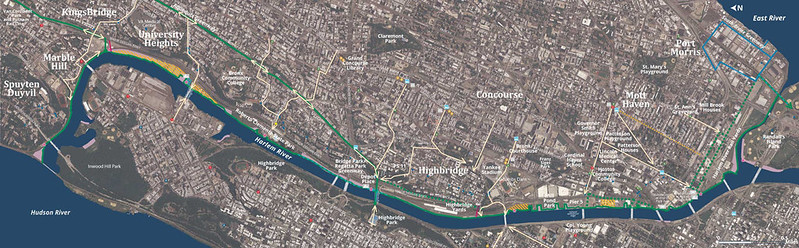 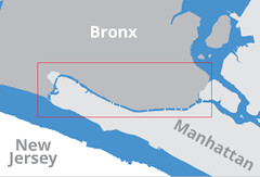 Building on the ideas and opinions that arose at those sessions, and using material from 2011 projects about the future of the river by graduate students at the Massachusetts Institute of Technology and Columbia University, as well as New York City's Vision 2020, the Harlem River Working Group has just published a bilingual, multi-page "greenprint" entitled "The Harlem River Greenway: Our River, Our Future." The document was created with the assistance of the Trust for Public Land and the Pratt Institute. Available at Community Board offices, elected officials' offices and community centers, the document unfolds to a three-foot, full-color map of the river, with dozens of specific, prioritized projects that are encompassed by these six basic objectives:
- build the Harlem River Greenway on the Bronx side of the river
- provide on-water access such as docks
- improve the environmental health of the water, with the goal of making it safe even for swimming
- create upland connections such as bus stops
- protect and restore the edge with an understanding of climate change
- make sure to benefit all stakeholders
The document is rich with detailed suggestions, such as "prioritize locations for boat launches in close proximity to underserved areas such as Lincoln Avenue, Park Avenue, Depot Place and Regatta Park;" "add access by extending the 161st Street pedestrian bridge to the waterfront;" and "acquire the four-acre waterfront site south of University Bridge for new waterfront park and public access." There are many more. 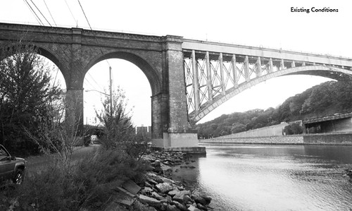 Several pieces of the plan are already in motion, including the reopening of the High Bridge, improvements to Depot Place Park and construction of a 1.5 mile Regatta Park Greenway. According to HRWG Coordinator Chauncy Young and Andy Stone of the Trust for Public Land, the next steps are pushing for funding and creating programs to draw people to the shore. 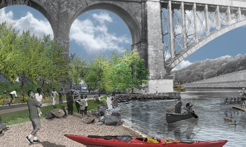 "We need to bring these visions to fruition," Mr. Young said, mentioning Depot Place as "one of the really exciting projects" that could go forward soon. Transferred from private ownership to the NYC Parks Dept about a year ago, the HRWG vision for this section of waterfront near the Washington Bridge "calls for a floating dock, boat access, a boathouse, a natural beach, community gardens and a greenhouse." "Then, the issue is getting people to these places -- having festivals, scheduling bike rides, etc.," said Mr. Stone. At lower right, a rendering from Starr Whitehouse Landscape Architects and Planners shows the shorefront transformed. Having worked on several wide-ranging plans to open up NYC waterfronts in recent years, including with the Rockaway Waterfront Alliance and Green Shores NYC in Queens, Mr. Stone has a broad perspective. What makes the Harlem River project different from other waterfront projects he's worked on? "There are two things that make the Harlem River compelling," he answered. "First, the river is so cut off from the surrounding communities. It needs special attention to produce the continuous Greenway that other groups have made happen in other neighborhoods. In the case of the Brooklyn Greenway, for example, there are contiguous streets that lead to the waterfront. Here in the Bronx you have extra impediments -- the railroad, the Major Deegan, grade change -- that make this an unusual and challenging waterfront. Second, there are quite a few spots for edge restoration. There's not much of a natural edge anywhere, but there are plenty of opportunities to recreate it." The Harlem River Working Group wants your input. If your group wants to get involved, or you'd like to create a group to work on the river, or you'd like a copy of the "Our River, Our Future" greenprint, email Mr. Young at chauncyyoung@gmail.com. |
THE ROAD TO RESILIENCE
| | Municipal Art Society Offers a Series of Programs on Waterfront Restoration
On December 13th, in partnership with the Center for Urban Real Estate at Columbia University, the Municipal Art Society presents the first program in a new series called "The Road to Resilience." The free program, taking place at the Museum of Jewish Heritage - A Living Memorial to the Holocaust in southern Battery Park City from 9am to 1pm, is titled Sink or Swim: Principles and Priorities for Waterfront Restoration in a Post-Sandy Era. The program is free, but one must register here. Community leaders, civic officials (including MWA trustee Christopher Ward), innovative entrepreneurs and urban practitioners from New York and New Jersey will discuss the long-term investments in infrastructure and possible technical and design interventions to building waterfront resilience. Administrative mechanics and financial implications will be considered, too. Secretary of Housing and Urban Development, Shaun Donovan, appointed to oversee the federal recovery effort in the New York area, will deliver the opening keynote. The second program of the series, On the Road to Resilience: From the Ground Up, is scheduled for January 12. Look for more details in a future WaterWire. |
| MWA PARTNER SPOTLIGHT | |
Expanding every week, the Metropolitan Waterfront Alliance is more than a coalition; it's a force. We are ferry captains, shipping executives, park directors, scientists, sailors, paddlers, swimmers, teachers, urban planners, architects and more. Together, we advocate for the best possible waterfront in the best possible city, a waterfront that is clean and accessible to all, with a robust maritime workforce and efficient, affordable waterborne transportation. Join us! Contact Louis Kleinman at lkleinman@waterfrontalliance.org. Meet some Partners of the Metropolitan Waterfront Alliance:
Raritan Bay Paddling Club - Our mission is to increase access to and appreciation of the Raritan Bay and Lower Raritan River from paddle powered boats.
Red Hook Boaters - The Red Hook Boaters is an all-volunteer, not-for-profit organization that runs free kayaking and beach clean-up programs at Louis J. Valentino Park in the Red Hook section of Brooklyn.
Red Hook Container Terminal - Global leaders in port operations and transportation services.
Reynolds Shipyard - Reynolds Shipyard, incorporated in 1983, provides a wide range of maritime services including ship repair, launch/lighterage services and warehousing.
|
| WATERFRONT NEWSLINKS |
|
Gowanus toxins continue to worry"When the waters of the Gowanus Canal gushed over its banks during Hurricane Sandy, flooding the streets and the basements of homes and businesses nearby, it was not the water itself that most worried residents and officials..."The Brooklyn Bureau, November 29, 2012 Newtown Creek Alliance celebrates its 10th anniversary"On Wednesday, members of the Newtown Creek Alliance (NCA) celebrated their 10th Anniversary at Warsaw on Driggs Avenue in Greenpoint..."Greenpoint Star News, November 28, 2012 Sea Level Rising Much Faster Than U.N. Projections"A new peer-reviewed study by climate scientists finds the rise in sea level during the past two decades has been 60 percent faster than predictions from the United Nation's Intergovernmental Panel on Climate Change..."National Public Radio, November 28, 2012 Sandy Revives Debate Over Sea-Level Rise"Echoes of Superstorm Sandy remain from Manhattan's once-flooded streets to Maryland's battered boardwalks to New Jersey's washed-away beaches..."USA Today, November 28, 2012 Gowanus neighbors grill agency about canal"Brooklyn residents got a chance to ask questions of government agencies about Gowanus Canal flooding during the hurricane, but received few answers..."Greenpoint Star, November 28, 2012 At $600 Million, Is South Ferry Station Worth Reopening?"The Metropolitan Transportation Authority says it will incur $5 billion in costs related to Hurricane Sandy, forming part of New York Governor Andrew Cuomo's requests for federal aid. But some of the line items within that $5 billion tab are so high that we should question whether rebuilding and reopening is the right course...."Bloomberg News, November 28, 2012 S.I. Borough President Wants New Great Kills Ferry Service Made Permanent"Temporary ferry service has been added between Staten Island's south shore and Manhattan to help ease transportation issues following Superstorm Sandy..."CBS, November 26, 2012 Should We Build Massive Flood Gates in New York Harbor?"There are calls to protect New York from storms like Sandy with massive technological fixes. Is that a good use of a lot of money?"The Daily Beast, November 5, 2012
(back to top) |

|
|
|

