AICW Wish List AICW Wish List
I. Expect An AICW Wish List Shortly
 We have a LOT of exciting and interesting news to pass along in this Alert, so let me just quickly say that we are going to soon revive a tradition which used to be a regular SSECN practice. A "Wish List" is a series of questions/requests for information about marinas, anchorages, problem navigational stretches, and other topics about which we would very much like to have the cruising community's input. We are currently formulating just such a "Wish List" for the AICW, stretching north from Daytona Beach, Florida to North Carolina. Look for this document to appear in your in-box by early next week. We have a LOT of exciting and interesting news to pass along in this Alert, so let me just quickly say that we are going to soon revive a tradition which used to be a regular SSECN practice. A "Wish List" is a series of questions/requests for information about marinas, anchorages, problem navigational stretches, and other topics about which we would very much like to have the cruising community's input. We are currently formulating just such a "Wish List" for the AICW, stretching north from Daytona Beach, Florida to North Carolina. Look for this document to appear in your in-box by early next week.
We would VERY MUCH appreciate as much input from the cruising community as possible. OK, on with this Alert!
|
 North Carolina North Carolina
II. FANTASTIC Spring, 2013 Dockage Offer at Bennett Brothers Yachts/Cape Fear Marina - Wilmington, NC on the Cape Fear River
We have not one, but TWO really special spring, 2013 DOCKAGE DEALS from SALTY SOUTHEAST CRUISERS' NET SPONSORS to relay in this Alert. The first comes to us from Bennett Brothers Yachts/Cape Fear Marina!
HOW DOES A WEEK'S FREE DOCKAGE GRAB YOU???!!!!!
 The combined enterprises of Bennett Brothers Yachts and Cape Fear Marina guard the easterly banks of the Northeast Cape Fear River, just north of the 42-foot Isabel Holmes - Highway 117 bascule bridge, and only a hop, skip and jump from the downtown Wilmington waterfront. These good people are one of our oldest and most valued SALTY SOUTHEAST CRUISERS' NET SPONSORS! The combined enterprises of Bennett Brothers Yachts and Cape Fear Marina guard the easterly banks of the Northeast Cape Fear River, just north of the 42-foot Isabel Holmes - Highway 117 bascule bridge, and only a hop, skip and jump from the downtown Wilmington waterfront. These good people are one of our oldest and most valued SALTY SOUTHEAST CRUISERS' NET SPONSORS!
Well, fellow cruisers, hold on to your proverbial hats! Just yesterday, we received a message from President Patricia Bennett of Bennett Brothers Yachts. In all my 30+ years as a cruising guide author, I can't ever recall a better or more GENEROUS spring dockage special. This is really one for the books.
 Now, BOTH northbound snowbirds, and year round North Carolina cruisers, have an incredibly good reason to abandon the familiar confines of the AICW and cruise upstream on the Cape Fear River to Wilmington, NC, and Cape Fear Marina/Bennett Brothers Yachts, in particular. Now, BOTH northbound snowbirds, and year round North Carolina cruisers, have an incredibly good reason to abandon the familiar confines of the AICW and cruise upstream on the Cape Fear River to Wilmington, NC, and Cape Fear Marina/Bennett Brothers Yachts, in particular.
Read ALL the details of this rather incredible offer at:
http://cruisersnet.net/?p=112269
|
 South Carolina South Carolina
III. The "Tastiest" Dockage Deal on the AICW - Bucksport Marina, Statute Mile 377)
Now, here is what I call a SWEET DEAL! Bucksport Marina, A SALTY SOUTHEAST CRUISERS' NET SPONSOR, guards the western shores of the AICW/Waccamaw River, south of marker #36. For many years, this has been "the" place to stop and provision with some incredibly good, locally made sausage, known, appropriately enough, as "Bucksport Sausage."
On 4/18/13, WE RECEIVED A TELEPHONE CALL FROM OWNER, CAPTAIN RALPH SIMMS. EFFECTIVE IMMEDIATELY, AND RUNNING UNTIL 5/18/13, CRUISERS DOCKING OVERNIGHT (OR LONGER) AT BUCKSPORT MARINA WILL RECEIVE A FREE POUND OF THE FAMOUS BUCKSPORT SAUSAGE!!!!
 Coupled with the voluminous, positive reviews we've recorded here on the Cruisers' Net, following a change in this marina's ownership some two years ago, there is now EVERY reason to include this fine facility in your overnight cruising itinerary. Coupled with the voluminous, positive reviews we've recorded here on the Cruisers' Net, following a change in this marina's ownership some two years ago, there is now EVERY reason to include this fine facility in your overnight cruising itinerary.
So, stop by, tie up, eat at the excellent on-site restaurant, and RECEIVE YOUR FREE POUND OF BUCKSPORT SAUSAGE! Tell Ralph and company the Cruisers' Net sent you!

Full details at:
http://cruisersnet.net/?p=112318
|
 Eastern Florida Eastern Florida
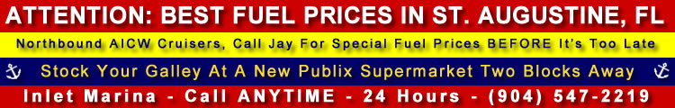
IV. Latest Update on St. Augustine Inlet Aids to Navigation (Statute Mile 776)
 Back in 2011, successful navigation of St. Augustine Inlet had become problematical at best, due to some serious shoaling. A welcome dredging project in 2012 solved most of these problems, but our good friend, Captain Jay Bliss, member of the St. Augustine Port Commission, keeps us up to date from time to time on the very latest inlet navigational conditions. Back in 2011, successful navigation of St. Augustine Inlet had become problematical at best, due to some serious shoaling. A welcome dredging project in 2012 solved most of these problems, but our good friend, Captain Jay Bliss, member of the St. Augustine Port Commission, keeps us up to date from time to time on the very latest inlet navigational conditions.
In the account linked below, taken from a recent Port Commissioners meeting, Captain Jay relates news about the refurbishment of inlet aids to navigation, and the removal of a marker.
All mariners who plan on making use of St. Augustine Inlet this spring or summer, should check out the full story at:
http://cruisersnet.net/?p=112334
And, speaking of St. Augstine, but on a wholly different topic, take a look at the chart image below:
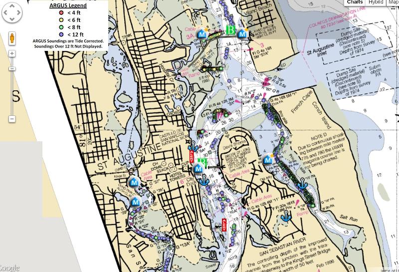
 This is a screen shot of one of our Chart View pages, centered on St. Augustine, WITH THE ARGUS LAYER TURNED ON. Look at ALL the useful depth information presented by ARGUS. Follow the link below to open a full size Chart View page centered on these waters, with the ARGUS layer already turned on. This is a screen shot of one of our Chart View pages, centered on St. Augustine, WITH THE ARGUS LAYER TURNED ON. Look at ALL the useful depth information presented by ARGUS. Follow the link below to open a full size Chart View page centered on these waters, with the ARGUS layer already turned on.
Remember, though, normally you will need to turn on the ARGUS layer manually, by clicking the "Argus(MLLW)" check box, on the above, left side of the chart image.

Check out:
http://cruisersnet.net/cruisersnet-marine-map/?ll=29.89898755141359,-81.3091508148193&z=14&argus=1
|
 Okeechobee Waterway/Eastern Florida Okeechobee Waterway/Eastern Florida
V. Okeechobee Waterway/St. Lucie River Shoaling Near AICW Intersection, Statute Mile 988.5
 The shoaling reported in the article linked below, cherry picked from the latest Local Notice to Mariners, lies along the easternmost section of the Okeechobee Waterway/St. Lucie River channel, immediately west of this passage's intersection with the AICW. Locally, these waters are known as "the crossroads" and shoaling is common here. The shoaling reported in the article linked below, cherry picked from the latest Local Notice to Mariners, lies along the easternmost section of the Okeechobee Waterway/St. Lucie River channel, immediately west of this passage's intersection with the AICW. Locally, these waters are known as "the crossroads" and shoaling is common here.
Soundings have grown so thin along this stretch that captains piloting boats with a draft greater than 5 feet, may very well want to time their passage of these waters for mid to high tide.
 FOLLOW THE LINK BELOW TO LEARN EXACTLY WHERE THESE SHALLOWS ARE FOUND, and exercise the greatest caution when cruising this section of the Okeechobee Waterway/St. Lucie River. FOLLOW THE LINK BELOW TO LEARN EXACTLY WHERE THESE SHALLOWS ARE FOUND, and exercise the greatest caution when cruising this section of the Okeechobee Waterway/St. Lucie River.
If any local Stuart area cruisers have personal experience with this shoaling, we request that you send us further information! You can e-mail us directly at CruisersNet@triad.twcbc.com, or use the "Comment" function found at the bottom of the below linked article, or follow the "Click Here to Submit Cruising News" link/button found on the upper, right of all (except Chart View) SSECN pages.
Get the full story, and the critical details at:
http://cruisersnet.net/?p=112338
|
 South Carolina South Carolina
VI. Heritage Plantation Marina (St. M. 394.5) Seeks New Dockmaster
 The Salty Southeast Cruisers' Net has been contacted by Captain Darla Spillane, property manager for Heritage Plantation and it's adjoining marina. We have happily agreed to assist in her search for a new Heritage Plantation Marina dockmaster. If this position is of any interest to you, please follow the link below for a full description of the job requirements, and info as to how you may contact Ms. Spillane directly. The Salty Southeast Cruisers' Net has been contacted by Captain Darla Spillane, property manager for Heritage Plantation and it's adjoining marina. We have happily agreed to assist in her search for a new Heritage Plantation Marina dockmaster. If this position is of any interest to you, please follow the link below for a full description of the job requirements, and info as to how you may contact Ms. Spillane directly.
Heritage Plantation Marina guards the eastern shores of the AICW/Waccamaw River between marker #79 and Butler Island, a few miles north of Georgetown, SC. While this facility was once open only to residents, over the past several years there has been a change in philosophy, and cruising visitors have been once again welcomed.
For more details, please visit:
http://cruisersnet.net/?p=112171
|
 South Carolina South Carolina
VII. Senseless Vandalism at the Georgetown Lighthouse
Talk about doing something really dumb and malicious, the historic Georgetown, South Carolina Lighthouse was broken into April 9. 2013. The electrical and lighting systems were so badly damaged, the lighthouse is now inoperable. The good news is that it appears as if at least one of the vandals received a nasty electrical shock while performing their mischief.

The Georgetown Lighthouse is located on North Island, at the mouth of Winyah Bay. It is not generally visible during daylight hours from the path of the AICW.
Follow the link below to read a full news article about this senseless crime in the "Georgetown Times."
http://cruisersnet.net/?p=111967
|
 Florida Keys Florida Keys
VIII. Damaged Florida Keys Inside Route Aid to Navigation, Statute Mile 1108
The destroyed aid described in the below linked article, lies in a narrow channel of many markers that leads into Goulds Canal, on the western shore of Biscayne Bay. The entrance to the channel is found 3 nautical miles west of the marked Florida Keys Inside Route's passage through Featherbed Bank at Statute Mile 1108.  Full details at: http://cruisersnet.net/?p=112178
|
 Western Florida Western Florida
IX. Big Sarasota Pass Discussion
The series of messages linked below was originally copied from "The Cruisers' Forum" (http://www.cruisersforum.com), an alternate information outlet highly recommended by everyone here at the SSECN! Since its original publication on the SSECN only 48 hours ago, some of our visitors have added even more to this discussion.
 If you are not familiar with Sarasota, this community actually has two inlets, Big (Sarasota) Pass and New Pass. Having sounded both many times over the years, I can say unequivocally that I do NOT recommend that cruising size craft use either seaward passage. Even with the info very thoughtfully provided by the Sarasota Yacht Club (see the below linked article), it's a dicey proposition at best to run Big Pass. Don't even think about trying New pass! If you are not familiar with Sarasota, this community actually has two inlets, Big (Sarasota) Pass and New Pass. Having sounded both many times over the years, I can say unequivocally that I do NOT recommend that cruising size craft use either seaward passage. Even with the info very thoughtfully provided by the Sarasota Yacht Club (see the below linked article), it's a dicey proposition at best to run Big Pass. Don't even think about trying New pass!
Learn LOTS more about the Sarasota inlet situation, and where the nearest reliable seasward passages are located, by visiting:
http://cruisersnet.net/?p=111868
|
 Georgia Georgia
X. Derelict Adrift near Jekyll Harbor Marina, AICW Statute Mile 684.5
Frequent Salty Southeast contributor, Captain Sonny, reports a small, derelict sailboat in the unnamed creek to the west of SALTY SOUTHEAST CRUISERS' NET SPONSOR, Jekyll Harbor Marina. The downstream flow of the creek west of Jekyll Harbor is eastward toward the Waterway and, should the derelict drift out of the creek, it could become a hazard to AICW navigation.
Learn all there is to know, and see a photo of the derelict sailcraft at:
http://cruisersnet.net/?p=111817
|
 North Carolina North Carolina
XI. Expect Daylight Closures of Alligator River Bridge, AICW Statute Mile 85
Capt. Hartman's report linked below indicates that, contrary to earlier notices, closures of the Alligator River Bridge (closed vertical clearance a mere 14 feet) are occurring during daylight hours and are affecting navigation.

Learn lots more at:
http://cruisersnet.net/?p=108711
|
 Florida Keys Florida Keys
XII. HAZARD: Bache Shoal Aid to Navigation Damaged, Hawk Channel, near AICW Statute Mile 1110, April 17, 2013
 The Hawk Channel aid to navigation reported as damaged in the report linked below, cherry picked from the latest Local Notice to Mariners, lies near the northern tip of Bache Shoal and 1.8 nautical miles due east of Sands Key. This portion of Hawk Channel stretches between Miami's Government Cut Inlet and Key Largo. The Hawk Channel aid to navigation reported as damaged in the report linked below, cherry picked from the latest Local Notice to Mariners, lies near the northern tip of Bache Shoal and 1.8 nautical miles due east of Sands Key. This portion of Hawk Channel stretches between Miami's Government Cut Inlet and Key Largo.
Full details at:
http://cruisersnet.net/?p=108711
|
 North Carolina North Carolina
XIII. Edenton, North Carolina Slated to Hold 300th Anniversary Celebration Cruiser Rally 5/6/13 to 5/12/13
 As part of its 300'th Anniversary, the charming and historic town of Edenton, North Carolina, a SALTY SOUTHEAST CRUISERS' NET SPONSOR, is planning on a HUGE event to welcome the cruising community during the week of May, 6-12, 2013. As part of its 300'th Anniversary, the charming and historic town of Edenton, North Carolina, a SALTY SOUTHEAST CRUISERS' NET SPONSOR, is planning on a HUGE event to welcome the cruising community during the week of May, 6-12, 2013.
There will be FREE dockage at the city marina (during the week of 5/6/13 to 5/12/13 ONLY!), as well as a water taxi if the marina becomes full, and some vessels need to anchor off the town waterfront! Coupled with this community's many historic and striking homes and public buildings, CRUISERS HAVE MANY, MANY REASONS TO LEAVE THE COMFORTABLE CONFINES OF THE AICW AND CRUISE WEST ON ALBEMARLE SOUND TO THE EDENTON WATERFRONT! SEE YOU THERE!!!!
Lots more details at:
http://cruisersnet.net/?p=112303
|
 Western Florida Western Florida
XIV. Regatta Pointe Marina Will Host West Marine Nautical Expo 5/4/13 to 5/5/13 (Manatee River, off Tampa Bay)
 This just in from SALTY SOUTHEAST CRUISERS' NET SPONSOR, Regatta Pointe Marina. This fine facility guards the northern banks of the Manatee River, just west of the Highway 41 Business Bridge, and hard by the community of Palmetto, Florida. Sounds like a GREAT weekend, with some really interesting seminars. Come one, come all!Full details at:http://cruisersnet.net/?p=112310 This just in from SALTY SOUTHEAST CRUISERS' NET SPONSOR, Regatta Pointe Marina. This fine facility guards the northern banks of the Manatee River, just west of the Highway 41 Business Bridge, and hard by the community of Palmetto, Florida. Sounds like a GREAT weekend, with some really interesting seminars. Come one, come all!Full details at:http://cruisersnet.net/?p=112310  That's all for now. Good luck and good cruising to all! That's all for now. Good luck and good cruising to all! Claiborne S. Young Salty Southeast Cruisers' Net |
|