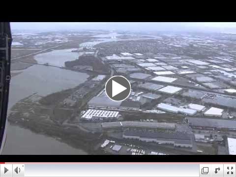
NEW YORK - Coast Guard officials teamed with various local, state and federal officials to assess the impact of Hurricane Sandy since the storm's landfall on Tuesday. For those looking to get some idea of the scope of the damage in the New York/New Jersey area, there probably doesn't exist a better perspective than the one provided by the Coast Guard's flyovers, via both helicopter and airplane.
For example, a Coast Guard Air Station Cape Cod, Mass., helicopter crew conducted an over-flight of New Jersey and New York coast and waterways on Oct. 30. The crew observed extensive land and property damages during the flight. You can see video they provided of their survey here:
 |
|
Coast Guard assessing the Sandy damage in New York and New Jersey |
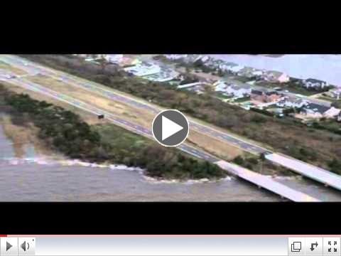
On that same day, Congressman Peter King, Tim Bishop, Steve Israel, Congresswoman Carolyn McCarthy and Rear Adm. Daniel Abel, 1st Coast Guard District commander, flew over Long Island, N.Y. The Coast Guard Air Station Cape Cod, Mass., HC-144 flight covered nearly the entire southern edge of Long Island and many effected areas along the coast. Petty Officer 2nd Class Rob Simpson supplied video of the event, which you can watch here:
 |
|
Overflight assessment of Long Island post-Sandy |
In addition, NOAA Office of Coast Survey navigation response teams and other survey assets are in the water (or soon will be), as they begin checking for underwater debris and shoaling that may pose a risk to navigation. Tasked by the U.S. Coast Guard Captains of the Port, these vessels can use multibeam echo sounders or side scan sonar, as conditions warrant, to search for the answers that would speed resumption of shipping and other vessel movements.
NOAA Ship Thomas Jefferson started out yesterday morning for New York Harbor, where they will survey for obstructions in waterways, starting a daybreak tomorrow. Visual reconnaissance indicates debris and missing containers may pose a danger to shipping.
Navigation Response Team 5 mobilized from Connecticut and got underway in New York at first light yesterday, surveying Anchorage Channel. Their next priorities were the route up to the Manhattan cruise ship terminal, Sandy Hook Channel, and then the Global Marine Terminal.
NOAA Ship Ferdinand Hassler spent the past two days surveying deep draft ship channels in Chesapeake Channel and Thimble Shoal Channel, as 78 large vessels, including portions of the Navy's Atlantic Fleet, waited to transit through the entrance to Chesapeake Bay.
NOAA R/V Bay Hydro II wassurveying in the Hampton Roads area the past two days, checking channels needed by coalshipments and aircraft carriers at Norfolk.
Navigation Response Team 2 headed from their regularly scheduled surveying off Florida's coast to help out in NY/NJ. Additionally, an operations manager is transporting mobile survey equipment to New York, as an additional survey resource on a vessel of opportunity.
NOAA R/V Potawaughmobilized yesterday to Lewes, Del., to survey for shoaling that may pose a risk to safe navigation for the Cape May - Lewes Ferry and other vessels. They started surveying, using the multibeam echo sounder, at 1 pm yesterday.
Meanwhile, the Port Authority of New York and New Jersey said this morning that maritime facilities are closed until further notice. Staff and engineers are inspecting facilities and conditions to assess damage and are waiting until it's safe to resume operations before opening back up. They recommend following their updates on Twitter at @PANYNJ.
However, the Port of New York is open to all tug and barge traffic carrying petroleum products. Also, New York waterway ferries and taxi service are fully operational on the Hudson and East Rivers. Gravesend Bay anchorage south of the Verrazano Bridge as well as the anchorage north of the bridge is open and anchorage north of the bride is scheduled to be open later Thursday.
Finally, the Hudson River is open to all vessel traffic north of George Washington Bridge and the Kill Van Kull is open to light tugs.


