2013 Hillsborough River Interlocal Planning Board Meeting Dates:
Tuesday, MAY 21
(Joint meeting with TAC to be held at Southwest Florida Water Management District's Tampa Service Center at 1:30 p.m., Laurel Oaks Room, at 7601 US Hwy 301, Tampa, FL 33637)
Monday, AUG 26
Tuesday, DEC 10
Unless otherwise noted,
River Board meetings will
be held at 9:30 a.m. at:
Temple Terrace City Hall
at 11250 N 56th Street
2013 Technical Advisory Council (TAC) Meeting Dates on Tuesdays: March 19 April 16 May 21 (Joint Mtg w River Board) June 18 July 16 August 20 September 17 October 15 November 19 December 17 All TAC meetings will be held at Southwest Florida Water Management District's Tampa Service Center at 1:30 p.m.
in the Laurel Oaks Room at
7601 US Hwy 301 in Tampa For more information on the Hillsborough River Interlocal Planning Board & Technical Advisory Council, please contact staff at 813.272.5940 or visit: www.hillsboroughriver.org
|
|

|
|
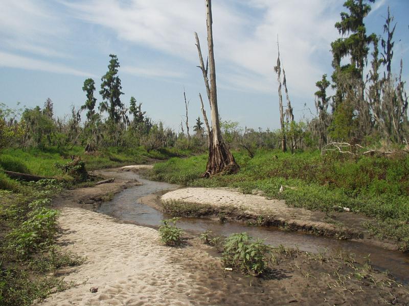
River Facts
Geological data suggests that the Hillsborough River has been flowing for about 27,000 years. Humans first made their way to this area 12,000 - 15,000 years ago.
In the late 18th century the watershed of the Hillsborough River was a land covered by a rich, old growth forest. Majestic bald cypress, longleaf pine, and sand live oak were hundreds of years old (and in the case of cypress, thousands of years old).
In the mid to late 19th century to about 1913 the watershed of this old growth forest began to be logged. As a result of this lumbering activity, most of the trees within the Hillsborough River basin are now less than one hundred years in age.
The harvesting of the old growth trees altered the ecosystems they dominated. Trees such as water ash and water locust were able to quickly grow in the sun-lit spaces created when bigger trees were removed. The riverine swamp forest we see today has a much different ecology than the ecosystem that had existed along the Hillsborough for the previous ten to fifteen thousand years.
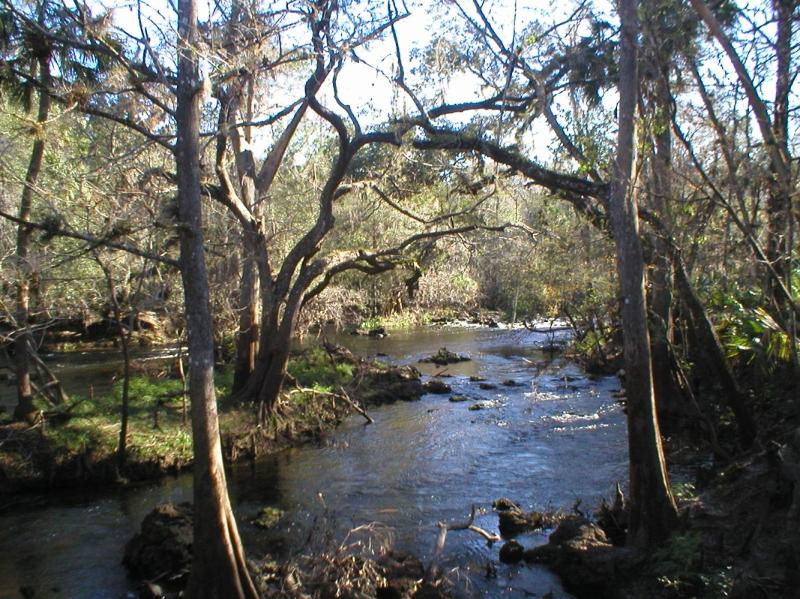 | |
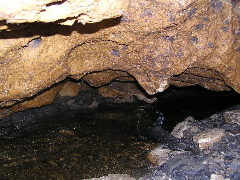
Upper Hillsborough River at Hillsborough River State Park
|
|
|
|
Members news
|
 | |
Dr. Richard Brown
|
The Hillsborough River Technical Advisory Council (TAC) is pleased to announce the re-election of Dr. Richard Brown as Chair and Mr.
 | |
Peter Owens
|
Peter Owens as Vice Chair.
Also, we are sad to announce Mr. Ben Koplin, ex- officio City of Tampa Staff member, is departing the TAC. Mr. Koplin has been a valuable contributor to the TAC's important work. We wish Mr. Koplin all the best in his future endeavors.
The River Board is scheduled to elect officers at the upcoming May regular meeting.

|
Florida's aquifer models full of holes, allowing more water permits and pollution
By Craig Pittman, Times Staff Writer
Published Sunday, January 27, 2013 
During a dry day in April 2010, scientists trying to trace the source of pollution in Silver Springs dropped 30 pounds of fluorescent dye into several wells and sinkholes a few miles away. What happened next did more than show the pollution woes facing the state's springs are more serious than anticipated. It also highlighted a flaw in how water pumping permits are routinely issued throughout much of Florida, suggesting the state has issued thousands of permits while underestimating their impact. It may also explain why some of the state's springs have lost some or all of their flow. State officials base all their permitting decisions on computer models that use a false assumption. The models assume that the aquifer flows at a steady rate through layers of sand and gravel.
 Actually, what's beneath our feet is called karst - a landscape made of limestone that's full of holes both big and small, where water sometimes shoots through as if sprayed by a firehose. The dye test gave a vivid illustration of the difference. The scientists running the test picked their drop sites with help from one of the state's models. The model predicted how fast a liquid would trickle along underground toward the spring. Different zones would give the dye a 2-year trip, a 10-year trip and even a 100-year trip. But when they dropped the dye in, the stuff rocketed through the aquifer. It zoomed across half the predicted 100-year distance in just six months. "It was going a mile a month," said Pete Butt, the scientist who oversaw the test. The dye would have traveled even faster had the test been conducted during the rainy season, he noted. Actually, what's beneath our feet is called karst - a landscape made of limestone that's full of holes both big and small, where water sometimes shoots through as if sprayed by a firehose. The dye test gave a vivid illustration of the difference. The scientists running the test picked their drop sites with help from one of the state's models. The model predicted how fast a liquid would trickle along underground toward the spring. Different zones would give the dye a 2-year trip, a 10-year trip and even a 100-year trip. But when they dropped the dye in, the stuff rocketed through the aquifer. It zoomed across half the predicted 100-year distance in just six months. "It was going a mile a month," said Pete Butt, the scientist who oversaw the test. The dye would have traveled even faster had the test been conducted during the rainy season, he noted.
Current and former state officials acknowledge that there's a false assumption behind all their modeling. They accept it as something they have to live with and work around. But critics argue the computer models are as full of holes as the karst itself. They are so far off-base "they shouldn't be used to make decisions," said David Still, former executive director of the Suwannee River Water Management District. Much of Florida's water for drinking and sprinkling comes from its aquifer. Because it lies deep in the earth, the state's water districts rely on modeling in making decisions about how much can be pumped out without harming nearby springs, lakes and wetlands, not to mention other water users. "It's the primary tool that's used for looking at what the impacts of groundwater withdrawals will be," said Ken Weber, who until last year oversaw permitting for the Southwest Florida Water Management District, commonly known as SWFWMD or 'Swiftmud'. The agency approved more than 1,000 permits for its 16-county area last year and rejected only two. The computer models - a series of mathematical equations based on data from wells and other sources - have also been crucial to the state's effort to track nitrate pollution from fertilizer, sewage and animal waste that have fouled the springs and fueled the growth of toxic algae blooms. Florida's water districts have been relying on computer models since the late 1970s, Weber said, and the models have gotten better over the years. But they all suffer from the flaw exposed by the Silver Springs dye test. They all assume the aquifer is filtered through layers of sand and gravel. "It assumes the aquifer is a sandbox," said Todd Kincaid, a geohydrologist critical of the state's computer models. "The water flows through the porous spaces between the grains." But what lies underground around the state's approximately 1,000 springs is karst. The holes in karst function as speedways for flowing water as well as pollution.
"Things travel a lot faster than was previously thought," Weber said. That means that when pollution spills into the ground, "tha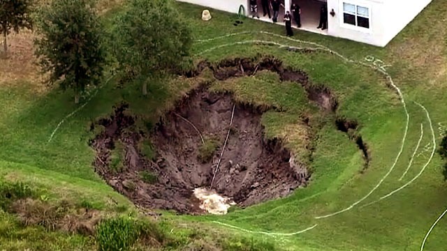 t stuff can get into the water supply much faster." Darrin Herbst, now in charge of SWFWMD's permit program, contended that his staff can tweak the models to fit what they see pumping doing to the aquifer, so there should be no problem. However, he acknowledges their model tweaking did not foresee what happened three years ago in Plant City: Farmers trying to protect their crops during a freeze pumped so much water that the aquifer dropped 60 feet in just days. As a result, 140 sinkholes opened up throughout the region. "The magnitude caught us off-guard," he said. The models still do all right when they are focused on projecting the aquifer's flows on a regional scale - say, covering from Central Florida to the coast - because "you can be off by quite a bit but it doesn't matter," Weber said. But looking at a smaller area for individual permits is "a lot trickier.'' A lack of information about what's underground is the big problem, studies show. "Very little has been done as far as travel time and flow path mapping at springs in Florida," a 2008 geological study of the springs along the Santa Fe River noted in criticizing the inaccurate models. Dye tests in that area showed "travel times in this system were up to one mile per day," far faster than what the models predicted. t stuff can get into the water supply much faster." Darrin Herbst, now in charge of SWFWMD's permit program, contended that his staff can tweak the models to fit what they see pumping doing to the aquifer, so there should be no problem. However, he acknowledges their model tweaking did not foresee what happened three years ago in Plant City: Farmers trying to protect their crops during a freeze pumped so much water that the aquifer dropped 60 feet in just days. As a result, 140 sinkholes opened up throughout the region. "The magnitude caught us off-guard," he said. The models still do all right when they are focused on projecting the aquifer's flows on a regional scale - say, covering from Central Florida to the coast - because "you can be off by quite a bit but it doesn't matter," Weber said. But looking at a smaller area for individual permits is "a lot trickier.'' A lack of information about what's underground is the big problem, studies show. "Very little has been done as far as travel time and flow path mapping at springs in Florida," a 2008 geological study of the springs along the Santa Fe River noted in criticizing the inaccurate models. Dye tests in that area showed "travel times in this system were up to one mile per day," far faster than what the models predicted.
 Harold "Hal" Wilkening, who heads up the division of water resources at the St. Johns River Water Management District, conceded that the sand-and-gravel model "is not going to be as precise or reliable for a karst landscape."But creating a more accurate one is nearly impossible given all the fissures and cracks", he said. "There really isn't any way around it unless you have a lot of money to spend to find all those conduits underground," agreed Weber. Not true, said Kincaid. He developed a karst-based computer model - at the behest of Coca-Cola. Coca-Cola was operating a bottled water plant near High Springs and became concerned pollution from nearby farms might contaminate its source of water. According to Kincaid and Coca-Cola vice president Jonathan Radtke, the company hired Kincaid to put together a more accurate model. It took four years and $400,000. When it was done in 2007, Kincaid said, they presented it to officials from the state Department of Environmental Protection, three water management districts and the U.S. Geological Survey. "Coca-Cola said (to the state officials), 'We'll give it to you for free, give you the software to run it, send your guys to the courses and show them how to run it.' They said no," Kincaid recalled. "Because it was built by a corporation, they couldn't touch it." Still, who was the head of the Suwannee River water district at the time, said his staff never told him about the alternate model. If they had, he said, "I would've taken it." Coca-Cola gave up on the idea and no longer owns the bottling plant, Kincaid said. But state officials continue to resist changing their model even though they know it's wrong, he said. "They don't want to have any impediment to permit issuance," he said. The current computer models let them continue cranking out water-use permits, so "why would they want to mess with that?" Harold "Hal" Wilkening, who heads up the division of water resources at the St. Johns River Water Management District, conceded that the sand-and-gravel model "is not going to be as precise or reliable for a karst landscape."But creating a more accurate one is nearly impossible given all the fissures and cracks", he said. "There really isn't any way around it unless you have a lot of money to spend to find all those conduits underground," agreed Weber. Not true, said Kincaid. He developed a karst-based computer model - at the behest of Coca-Cola. Coca-Cola was operating a bottled water plant near High Springs and became concerned pollution from nearby farms might contaminate its source of water. According to Kincaid and Coca-Cola vice president Jonathan Radtke, the company hired Kincaid to put together a more accurate model. It took four years and $400,000. When it was done in 2007, Kincaid said, they presented it to officials from the state Department of Environmental Protection, three water management districts and the U.S. Geological Survey. "Coca-Cola said (to the state officials), 'We'll give it to you for free, give you the software to run it, send your guys to the courses and show them how to run it.' They said no," Kincaid recalled. "Because it was built by a corporation, they couldn't touch it." Still, who was the head of the Suwannee River water district at the time, said his staff never told him about the alternate model. If they had, he said, "I would've taken it." Coca-Cola gave up on the idea and no longer owns the bottling plant, Kincaid said. But state officials continue to resist changing their model even though they know it's wrong, he said. "They don't want to have any impediment to permit issuance," he said. The current computer models let them continue cranking out water-use permits, so "why would they want to mess with that?"
| |
|
|
Legislature expected to revisit fertilizer rules
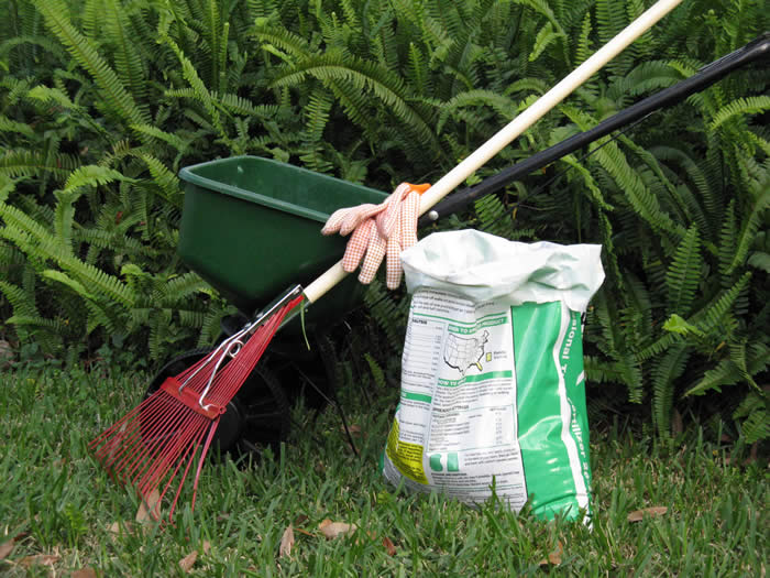
In preparation for another battle over fertilizer ordinances, the Florida Association of Counties has voted to make protecting fertilizer restrictions one of its top three issues going into the 2013 legislative session.
"We've been told it's imminent," Sarasota County commissioner Nora Patterson, said of the potential legislation to limit local control of fertilizer use, according to the Sarasota Herald Tribune. The issue is whether local governments can pass tighter regulations than the state's minimum recommendations to help meet the more stringent criteria for nitrogen in surface waters recently approved by state and federal agencies. Sarasota County passed the state's first fertilizer ordinance in 2007 with officials promising to push for repeal if they saw lawns dying for lack of nutrients. To date, only one complaint has been made but the sick grass was probably caused by overwatering, not under fertilizing. Since then, the cities of St. Petersburg and Tampa as well as Pinellas and Manatee counties have passed ordinances that limit the use or sale of nitrogen fertilizer during the summer rainy season. Reprinted from Bay Soundings (Baysoundings.com)
| |
|
|
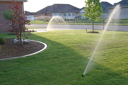
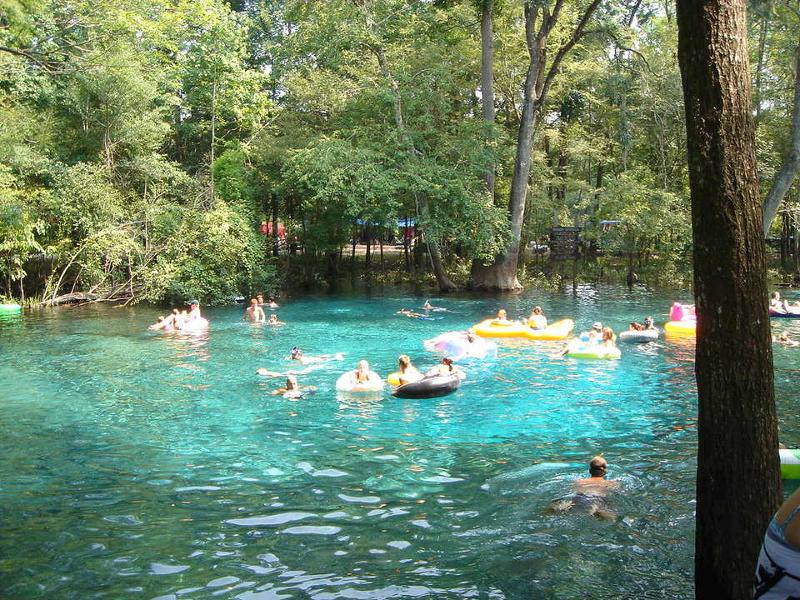
Lawn watering reduced to one day weekly in Tampa area
|
By Carl Lisciandrello
Published: February 26, 2013
Residents in Hillsborough, Pasco and Pinellas counties will face tighter watering restrictions starting March 13.
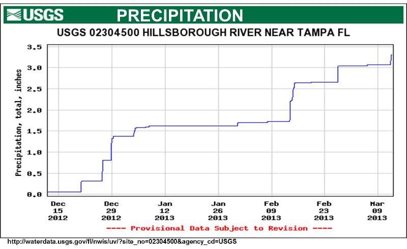
The Southwest Florida Water Management District's governing board voted Tuesday to enact the tighter controls as below-normal rainfall has resulted in
reduced river levels and increased water-supply concerns. The restrictions, which run through July 31, limit the watering of lawns to one day a week until rainfall and river levels increase, officials said. "For the last several months, we've watched the conditions decline," district Chairman Paul Senft said. "If we do not receive significant rainfall in the coming months, we may have to extend these restrictions into other areas of the district. We ask residents to be conservative with their water use, especially outdoor irrigation."
Currently, Hillsborough and city of Tampa residents are limited to watering twice a week before 8 a.m. or after 6 p.m. Pinellas County has similar irrigation restrictions. Under the new restrictions, watering will be limited to once a week, on a specified day based on address. Micro-irrigation and hand-watering of non-lawn areas will be allowed any day; but like all irrigation, such activity must now occur only during designated hours (before 8 a.m. or after 6 p.m. unless otherwise specified by a stricter local ordinance). Car washing is limited to once per week, and fountain operation will be limited to four hours per day. There are no changes to the Phase I restrictions in place for other water uses, including agricultural irrigation, golf course operations, industrial processes or pressure washing.
The issue was brought up Feb. 18 at a board meeting of Tampa Bay Water, the agency that supplies drinking water to 2.3 million people in Hillsborough, Pinellas and Pasco. Below-average rainfall and a reservoir under repair prompted Tampa Bay Water to recommend more watering restrictions to the district, board member Charlie Miranda said. "This is the time of the year when you have no rain or little rain," Miranda said. "Something needs to be done." Compounding the water shortage is the ongoing repairs to cracks in the C.W. Bill Young Regional Reservoir, Miranda said. The reservoir, which stored water from the Alafia River, Hillsborough River and Tampa Bay Bypass Canal, was drained in January for repairs. The structural problems that caused the cracks won't be fixed until next year. When full, the above-ground structure with 50-foot-tall walls holds 15.5 billion gallons of water that could be used during droughts. And it's been drier than usual, with Hillsborough getting only a total of 5.6 inches of rain since late September, said Granville Kinsman, a hydrologist for the water management district. "We should have had 10 inches of rainfall by now," Kinsman said. Low rainfall also means that river and ground water levels have decreased, he said. The levels of the Withlacoochee River, Hillsborough River and Peace River - which feeds water into the region - decreased to below-normal levels last month, a district report said. Warm weather also could cause residents to start using more water earlier than usual. "Spring looks like it came early," Kinsman said. "People are going out and buying plants and flowers. And they'll need water." For more information, visit the water district at WaterMatters.org/restrictions/.
|
|
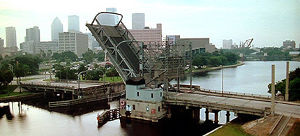
$2 Million sought for Laurel Street Bridge repair
|
TBO.com
By Kevin Wiatrowski
January 22, 2013
Mayor Bob Buckhorn is asking the City Council to approve nearly $2 million for emergency repairs to the aging Laurel Street Bridge after state officials discovered the drawbridge can no longer function properly. Council members will consider the request on Thursday. Inspectors with the Department of Transportation told the city in October the machinery that lifts the bridge has large cracks that allowed one of the gears to slip out of alignment. The damage was severe enough to close the bridge to boat traffic. In their report to the City Council, city officials say the damaged gear doesn't affect the surface of the bridge, which carries more than 5,000 cars a day. Venice-based Coastal Marine Construction Inc. won the bid to repair the bridge. It was one of two companies to apply for the job.
The 86-year-old Laurel Street Bridge is one of eight drawbridges that cross the Hillsborough River between Hillsborough Avenue and Platt Street. All of them are close in age, but two - Platt and Columbus Drive - have undergone recent renovations. The Laurel Street repairs will claim pretty much all the money the city has set aside for bridge repairs this year, according to the city's five-year transportation plan. The money comes from the city's surcharge on gasoline. Coastal Marine's bid calls for replacing bearings, switches and other electrical devices as well installing a new control panel and brake system. The Coast Guard requires that the city's drawbridge open to allow the passage of watercraft too tall to pass under them safely. While that can include sailboats, more recently it has included barges carrying cranes used to construction parts of the Riverwalk.
|
Planned highway becomes haven for wildlife
|
If all had gone as planned, Honore Avenue would be a bustling six-lane highway running south from Manatee County to Englewood. Instead, the 2.5 mile section just south of busy Fruitville Road is a two-lane road bordered by bioswales and punctuated with roundabouts that accommodate nearly as much traffic as a four-lane highway. Not only do the bioswales collect a significant percentage of pollution, neighbors love the design - and it cost $2.3 million less to build than the county had budgeted for a more traditional alternative."It's important to accommodate automobiles but there needs to be a balance," 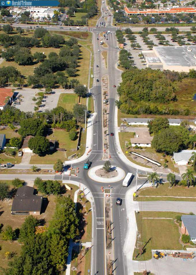 says Jon Thaxton, who served on the Sarasota Board of County Commissioners for 12 years before being term-limited out. "There is a balance here: there's room for automobiles but there's also a comfortable space for pedestrians and bicyclists - and the environment." says Jon Thaxton, who served on the Sarasota Board of County Commissioners for 12 years before being term-limited out. "There is a balance here: there's room for automobiles but there's also a comfortable space for pedestrians and bicyclists - and the environment."
In fact, the bioswales collect so much nitrogen that they played an important role in "delisting" nearby Roberts Bay. It's one of the few estuaries in the nation where water quality improved so dramatically that it is no longer considered impaired, notes Jack Merriam, the county's environmental manager for integrated water resources at the time the Honore Avenue project was built.
Another environmental advantage: the original plan called for clear-cutting about 17 acres of natural forested area to mitigate for drainage from a four-lane road with no bioswales. The final plan required just 1.2 acres of clear-cut land, protecting a mesic hammock and increasing the buffer area for two active bald eagle nests.
Molly Williams, then the lead stormwater engineer for design-build contractor Stantec, worked with the county's forestry experts, walking the property slated for clear-cutting to identify trees that needed to be saved. What started out as a 17-acre block of land ended up as a series of smaller parcels connected by meandering swales that protected nearly all of the healthy trees. In some areas along the road, boardwalks were used instead of sidewalks to save trees and allow pedestrians to enjoy welcome shade.
 Four retention ponds originally planned were reduced to just two, Williams said. Like the bioswales, they're surrounded by plants that remove nutrients from the water before it gets to creeks that lead to Roberts Bay. From a traffic perspective, the road with roundabouts keeps cars moving because they don't need to stop for red lights along the 2.5-mile section. Capacity is about 85% of a traditional four-lane but the number of serious accidents has dropped dramatically because there are no intersections. Four retention ponds originally planned were reduced to just two, Williams said. Like the bioswales, they're surrounded by plants that remove nutrients from the water before it gets to creeks that lead to Roberts Bay. From a traffic perspective, the road with roundabouts keeps cars moving because they don't need to stop for red lights along the 2.5-mile section. Capacity is about 85% of a traditional four-lane but the number of serious accidents has dropped dramatically because there are no intersections.
"Roadways are like hourglasses," Thaxton explains. "It doesn't matter how much capacity you have at the top and the bottom, the volume is determined by the size of the connection in the middle." Roundabouts slow traffic down but don't require that cars stop at traffic lights or for left-hand turns. They also nearly eliminate the potential for t-bone crashes that can cause serious injuries. "Someone would almost have to want to get hurt to have a serious accident on this road," he said. Stantec's senior traffic engineer, Francisco Domingo, also lives in an adjacent neighborhood so the project was particularly near to his heart. He walks the road several times a week, checking for tire marks on the curbs of the roundabouts that might indicate that a driver took the curves too quickly. "People caught on to how to use them even more quickly than we expected," he said. And with bioswales built between the road and the sidewalk, pedestrians are protected from careless drivers. "I never thought I'd see it happen, but people come from all over to use this sidewalk to teach their youngsters how to ride a bike," Domingo said. At some point, the county may have to compensate a builder who owns land that can't be developed because of the minor loss of road capacity when compared to a traditional four-lane highway, Thaxton notes. Still, the county saved millions in capital costs and will save even more in maintenance cost over the life of the road. "Nothing is maintenance free, but this is as close as it gets," Thaxton quips. No studies have been done to determine exactly how much pollution the Honore Avenue bioswales remove, but some data can be extrapolated from a previous study, Merriam said. Comparing older neighborhoods with grassy swales to newer neighborhoods with curbs and gutters indicates that the swales collect more than 90% of the nutrients. "And those were just the old-fashioned swales with grass that gets mowed," he points out. "These are planted with native plants and, in some cases, have specific media designed to hold water long enough to collect nutrients."
"Honore on Steroids" The success of Honore Avenue helped persuade Sarasota and the Southwest Florida Water Management District to take the concept a step forward with the redevelopment of Dearborn Street in downtown Englewood. Like Honore, Dearborn will incorporate features like bioswales, rain gardens and pervious paving. It will also be the first-ever project in the county with built-in water quality monitors to document the impact of the construction technology. The main street through historic Englewood, Dearborn's redevelopment has been somewhat stymied by the cost of businesses complying with water quality regulations enacted over the last 30 years, Thaxton notes. "What we've done is build a collective low-impact development system that allows businesses the (water quality) credits they need to increase their footprint." It's a win-win situation, he adds. "Businesses can afford to grow and the county wins because we have a thriving downtown district with increased property values."
Reprinted from Bay Soundings (Baysoundings.com)
|
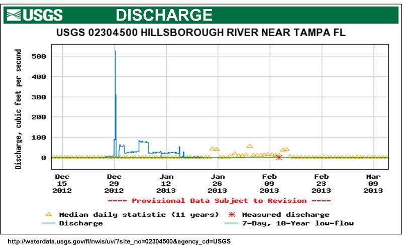
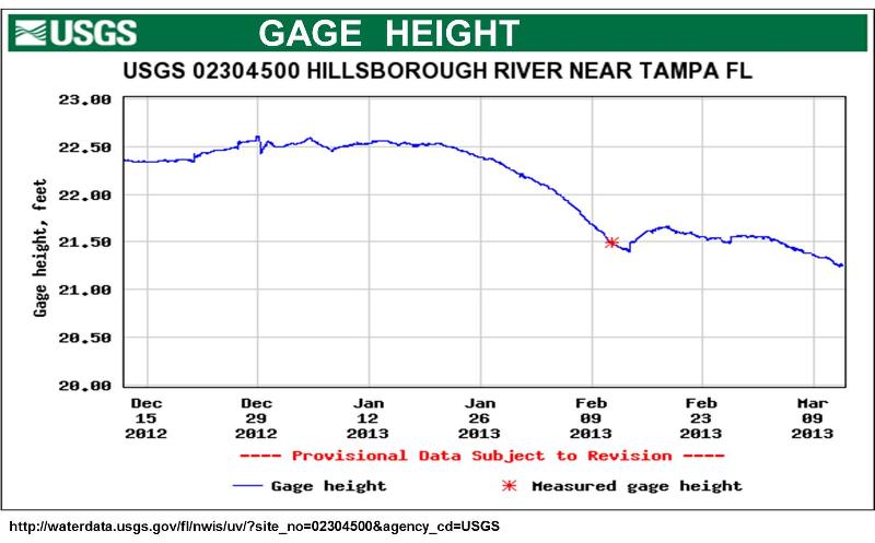
Stay current on your rivers with USGS WaterNow
|
For the first time, anyone can find out the current conditions on thousands of rivers and streams across the country, right from their phone, using USGS' latest system WaterNow. WaterNow makes the water conditions monitored by more than 16,000 streamgages and other sites across the country available via text or email. Like its predecessor and companion program, WaterAlert, WaterNow seeks to make USGS gage information for streamflow, groundwater levels, springs, water quality, and lake levels more readily available to the general public. These data have been available for over 10 years at USGS Water Data for the Nation, which requires a web browser to access.
"USGS is the world's largest provider of hydrologic information, and our streamgages are a vital part of that water infrastructure," said USGS Associate Director for Water Bill Werkheiser. "WaterNow brings that information straight from our streamgages to your smartphone, and keeps USGS data flowing at the cutting edge." Knowing about current water conditions is important for a variety of purposes, from disaster planning and response to recreation. For example, water levels in streams can be checked during floods to guide evacuations or on a bright weekend morning to plan a day of paddling.
Land and resource managers can benefit from WaterNow too. Not only can water levels be obtained, but also water temperatures can be checked to determine when it is necessary to release water from a reservoir to protect downstream trout fisheries. WaterNow expands on the service provided by the USGS WaterAlert service. WaterAlert provides a notification only when conditions exceed a threshold set by a user, whereas WaterNow provides data anytime on demand. These data are collected typically at 15 to 60-minute intervals, stored onsite, and then transmitted to USGS offices every hour.
So how does it work? It's easy! All you have to do is find the gage you are interested in using instructions found on the WaterNow page, and then send a message to WaterNow@usgs.gov with the site number of the gage you would like to get updates from. You will receive a reply within a few minutes that includes the most recent values of water level and streamflow, if available for that site. These data are by far the mostly frequently requested; therefore, they have been pre-set as defaults. Data values are also available for other kinds of data-collection sites such as wells, springs, and lakes.
For complete instructions and guides on what types of data might be useful to you or which streamgages might be of interest to you, visit the USGS WaterNow site!
|
|
In accordance with Title VI of the Civil Rights Act of 1964 and other nondiscrimination laws, public participation is solicited without regard to race, color, national origin, age, sex, religion, disability or family status. |
|
|
|