Alaska Satellite Imagery Newsletter - April
|
Greetings ,
There are a number of exciting new developments in the imagery collection industry this year. The DigitalGlobe and GeoEye merger has taken place allowing DigitalGlobe to provide better services to customers.
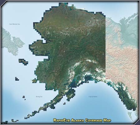
RapidEye has a complete statewide Alaska coverage in archive at 5 meter resolution. Check out the coverage map below or the higher resolution maps on the left sidebar, which includes a coverage frequency map showing how often areas of Alaska are imaged. This has gotten us really excited due to our ability to fuse the RapidEye imagery with point cloud data from IfSAR ORI, LIDAR or other sources in order to attain higher accuracy images. Our next newsletter announcement will detail this process more, so stay tuned!
Until next month,
-Steve Colligan, President
|
|
Spotlight: Satellite Imagery Provider Proves Ability to Respond Quickly
Sissonville WV, Interstate 77 Pipeline Explosion

(Click on a thumbnail image to to display in higher resolution).
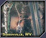
Sissonville WV, Interstate 77. A gas explosion (20 feet of pipeline ejected) and fire on the afternoon of December 11, 2012, destroyed buildings, road surface, and melted guardrails. This GeoEye-1 image of December 12, shows 800 feet of highway that was just repaired. Luckily, nobody was home in the buildings that were destroyed by the explosion, and there were only minor injuries. A section of corroded 20-inch diameter natural gas transmission line segment installed in 1967 was at fault. It took one hour to manually shut off the flow of gas to the fire after the explosion.
Read more about it here (goes to external website).
|