 |
|
CoCoRaHS
F L O R I D A
A Community Collaborative
Rain, Hail & Snow Network
|
|
|
|
 |
 |
 |
 |
 |
 |
 |
 |
 |
 |
 |
 |
 |
Welcome to the start of Summer! June 1st marks the meteorological start to the season, though the astrological start to summer happens on the Summer Solstice on June 21st. Either way you look at it, our summertime thunderstorms have made their debut causing localized heavy rains across the state.
With the start of summer, some of our observers will return to the north to escape the heat and humidity. Others will be taking vacations during the next few months. If you're gone for an extended absence, please take down your rain gauge so it doesn't become a hazard if the state is impacted by a landfalling tropical system. If you're just taking a week or two vacation, remember to use the Multi-Day Precipitation Report on your return.
So with the housekeeping out of the way, here are a few of the comments from May that I enjoyed.
FL-AL-40 on 5/3/2015: "High 79 Low 47. One of the lowest temps I ever seen in May. I think we can kiss that goodbye til October. 40's this morning in the Panhandle. Long range forecast has us in the 90's starting next Monday. Mostly clear and sunny yesterday and today as well. Full moon tonight. Also, something in the tropics is supposed to happen this week as well, but models have it pushing away from the US."
FL-NS-10 on 5/10/2015: "HAPPY MOTHERS DAY TO ALL YOU MOTHERS OUT THERE!"
FL-LE-22 on 5/17/2015: "Conditions at 7:00 AM: Clear with a light breeze from the northeast; Temp 74; Humidity 87%; Pressure 30.13 and rising. The low yesterday was 75 and the high was 89. The low so far this morning is 74. A large thunderstorm passed over the area early yesterday evening. There was quite a bit of lightening, but not enough to call severe and the wind was fairly light, but boy did it rain. Heavy rain fell for about 45 minutes, and at times reached rates of nearly 7 inches/hr."
FL-HB-10 on 5/23/2015: "What had been a controlled burn far away that got out of control....the smell of the smoke from that fire traveled here throughout the night, then after an overnight low of 74�, daybreak brought back sunshine and more searing heat with vengeance, with another early afternoon-long daytime high of between 96� and 98�...depending where you were in my yard....at my South Tampa location today, with little evidence of possible rainfall. Its hot out there! How hot? The bird bath water is evaporating."
FL-MR-13 on 5/27/2015: " 7am observations: 70F; partly cloudy; light breeze; patchy field fog; damp; colorful sunrise. Yesterday afternoon: started clouding up before 5pm rain started about 7pm and stopped about 8:20pm - with wind, thunder, lightening and heavy rain. Ponding and ditches that has not had water in them for several years. High was 93F and dropped to 74F during the storm. Neighbors lost electricity due to downed trees on power lines. Goats were very antsy yesterday afternoon prior to the storm......the geese loved the downpour......A neighbor about 1/4 mile to the north said they had rivers running through their property and that their rain gauge registered 4 inches."
|
Observer Photos
Typically in May, I travel to the beautiful state of Colorado to take part in the Technical Advisory Meeting for the CoCoRaHS program. This year, I wasn't able to make the trip, but my friend and fellow CoCoRaHS Coordinator Laura Edwards (SD), sent me a picture of the weather I was missing... SNOW! Last year, there was still some snowpack when we were up in Estes Park, CO, but nothing like this. I'm almost happy I didn't attend as I wouldn't have had the proper clothing to handle snow in May.
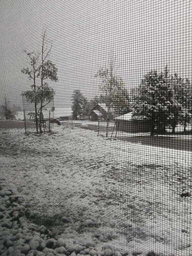
Instead, I've been able to capture pictures (like the one below) of some amazing thunderstorm structures that have formed on a daily basis since we've entered our Florida summer pattern.
If you've got any pictures you took on your travels, rainfall, floods, drought impacts, beautiful sunrises and sunsets, or anything else you'd like to share, please send them to me.
|
Quick Facts About May Observations
Registered Observers:
| 1,604 | Active Observers:
| 536 | Reports Submitted:
| 12,909 | Date of Most Reports:
| 432 on the 5th and 14th | Highest Rain Report:
| 5.52 on the 18th (FL-CR-37) | | Number of Observer Comments: | 1,218 |
|
May Rains
With the exception of some areas along the Panhandle and West Coast, the majority of the state had rainfall totals below normal (Figure 1). Departures from normal roughly ranged from -2.95" to 4.64" (Table 1), though localized parts of the state saw rainfall totals that were as much as 5.00" below normal to 8.00" above normal (Figure 1). May 2015 was the 6th driest on record at Vero Beach and the 9th driest in Orlando. There were multiple 24-hour precipitation records broken for the month (Table 2).
Table 1. May precipitation totals and departures from normal (inches) for selected cities.
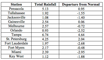
Table 2. Select daily rainfall records (inches) broken during May. (Compiled from NOAA, NWS)
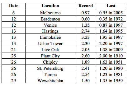
Figure 1. A graphical depiction of the monthly rainfall departure from normal (inches) for May is given in the figure below (courtesy of NOAA, NWS).
|
May CoCoRaHS Totals
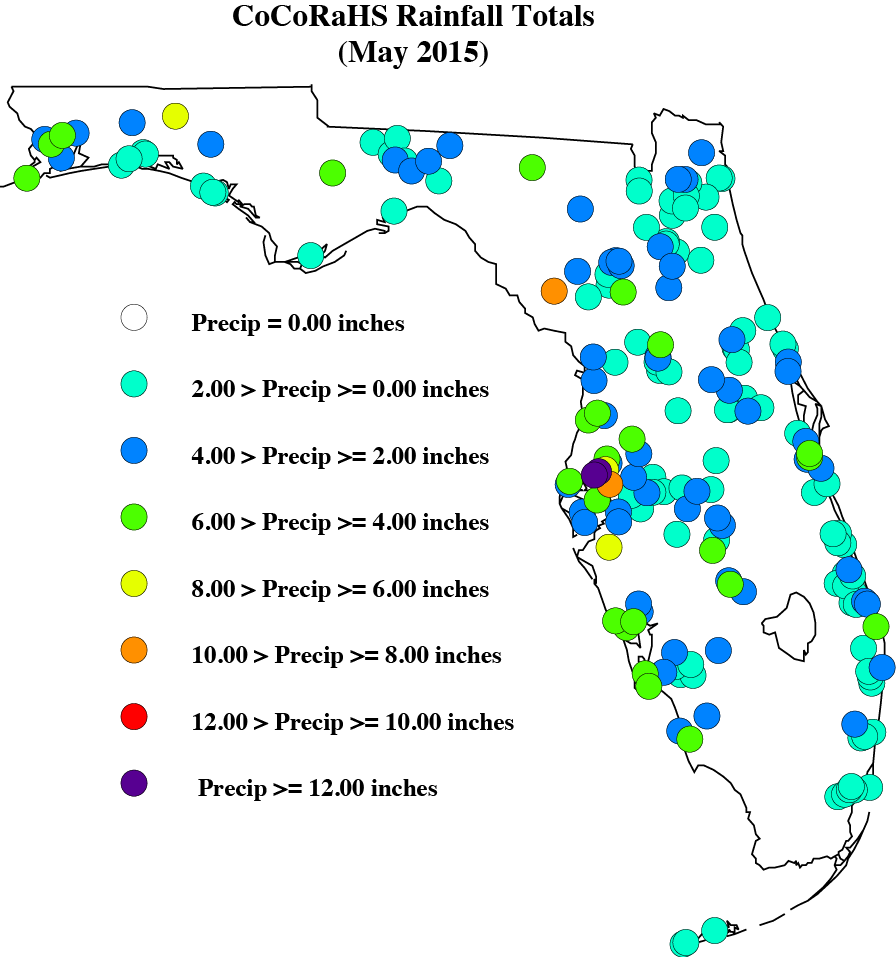
Here are the CoCoRaHS rainfall totals for May from some select CoCoRaHS stations across the state.
|
Current State of the Drought
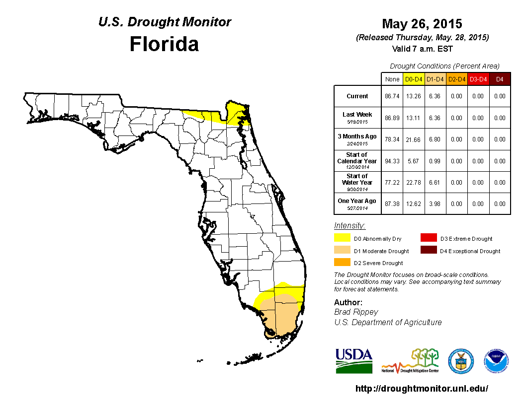
At the end of April, nearly 10% of the state was experiencing abnormally dry (D0) conditions, mainly concentrated in portions of southern Florida. After a wet April, precipitation across the state for May was closer to typical rainfall totals. May is a dry month for the state, so while some areas registered below normal rainfall, most of the state remained drought free. Rains at the beginning of the month in South Florida eased the moderate drought (D1) conditions, while the Panhandle experienced dryness (D0) in the northern parts of the counties. By the middle of May, D0 was introduced into Nassau County and the continued lack of rainfall in the southern Peninsula cause the expansion of D1 to Broward, Collier, Dade and Monroe counties. On the May 26th release of the drought monitor, the D0 area in the Panhandle had been removed, though the D0 area in the northeast continues to persist. Based on census data, roughly 3 million Florida citizens are currently being impacted by drought conditions reported in nearly 13% of the state. At the end of the month, the water level in Lake Okeechobee had dropped to under 13 ft., mainly due to regulatory releases.
|
Odds and Ends
Make sure to check out the monthly Wx Talk Webinars offered by CoCoRaHS. Each month features a different weather related topic and gives a chance for our observers to interact with the speaker. If you are unable to attend or have missed some of the previous month's talks, you can find them archived on the CoCoRaHS YouTube site: http://www.youtube.com/cocorahs/
Make sure to like Florida CoCoRaHS on Facebook! Observers can now post comments and pictures to the wall.
|
|
|
|
 |
 |
 |
 |
 |
 |
 |
 |
 |
 |
 |
 |
 |
|
|
 |
 |
|
 |
|