 |
|
CoCoRaHS
F L O R I D A
A Community Collaborative
Rain, Hail & Snow Network
|
|
|
|
 |
 |
 |
 |
 |
 |
 |
 |
 |
 |
 |
 |
 |
Now that I've gotten back into the swing of things, I'm back into my morning routine: checking my gauge, entering my report and then reading the observer comments over my second (or sometimes third) cup of coffee of the day.
So are just a few of the comments that were my favorites during the month of January.
FL-PB-39 on 1/1/2015: "HAPPY NEW BEAR!"
FL-DV-47 on 1/8/2015: "Cold this morning: 32. Frigid by our standards. But our place up on Beech Mountain NC was -10 this morning, staying below zero for a good 12 hours. Now THAT is cold! No rain and no rain predicted until Sunday or so."
FL-DV-63 on 1/9/2015: "IT SNOWED!!!!!!!!!!!!!!!!!!!!!!!"
FL-LE-22 on 1/23/2015: "The low yesterday was 64 and the high was 85. The low so far this morning is 68. A very welcome shower passed over the area yesterday evening. The shower did not produce much rain, but we are grateful for any we get this time of year. No thunder was heard or lightning observed."
FL-ST-12 on 1/24/2015: "Light rain began at 6:35 PM, preceded by occasional, distant thunder. Woke at about 2:30 AM to hear steady, heavy rain, with several loud, nearby thunder and lightening episodes. One sounded directly overhead. We were expecting rain all day Friday, but all we had was cloudy and quite windy conditions until nightfall. "
|
Groundhog Day
That Seer of Seers, Sage of Sages, Prognosticator of Prognosticators, and Weather Prophet Extraordinary Mr. Punxsutawney Phil will come out of Gobbler's Knob on the morning of February 2nd and let his prediction be known:
Will it be an early spring or six more weeks of winter?
If you're interested in finding out how accurate Phil's forecasts have been, the National Climatic Data Center has put out some information about the groundhog's predictions:
http://www.ncdc.noaa.gov/customer-support/education-resources/groundhog-day
|
Observer Photos
This month, Carolyn provided some pictures from New Smyrna Beach. This first picture is a beautiful sunrise over the Atlantic Ocean.
She sent these two pictures of heavy fog along the beach one morning. The fog was thick enough it made it hard to make out the ocean and beachside buildings.
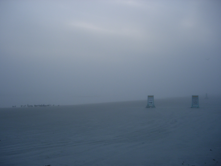 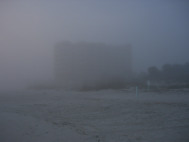
If you've got any pictures you took on your travels, rainfall, floods, drought impacts, beautiful sunrises and sunsets, or anything else you'd like to share, please send them to me.
|
Quick Facts About January Observations
Registered Observers:
| 1,574 | Active Observers:
| 556 | Reports Submitted:
| 13,214 | Date of Most Reports:
| 492 on the 13th | Highest Rain Report:
| 3.79 on the 23rd (FL-PK-1) | | Number of Observer Comments: | 1,421 |
|
January Rains
With the exception of a small portion of the Big Bend, and areas in north Central Florida and the interior Peninsula, most of Florida saw below average rainfall during January (Figure 1). Departures from normal roughly ranged from -1.76" to 1.17" (Table 1), though localized parts of state saw rainfall totals that were as much as 4.00" below normal to over 3.00" above normal (Figure 1). The last three months (November - January) have been the 4th wettest on record in Ocala, the 6th wettest for both Daytona Beach and Tallahassee and the 12th wettest in Orlando. A trace of snow was reported in Jacksonville on the 8th. There were multiple 24-hour precipitation records broken for the month (Table 2).
Table 1. January precipitation totals and departures from normal (inches) for selected cities.
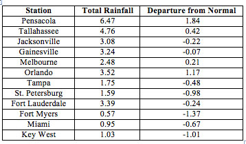
Table 2. Select daily rainfall records (inches) broken during January (Compiled from NOAA, NWS)
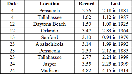
Figure 1. A graphical depiction of the monthly rainfall departure from normal (inches) for January is given in the figure below (courtesy of NOAA, NWS).
|
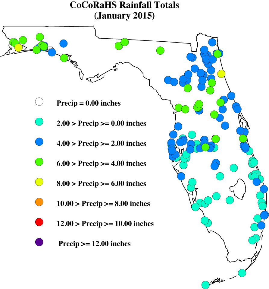
January CoCoRaHS Totals
Here are the CoCoRaHS rainfall totals for January from some select CoCoRaHS stations across the state.
|
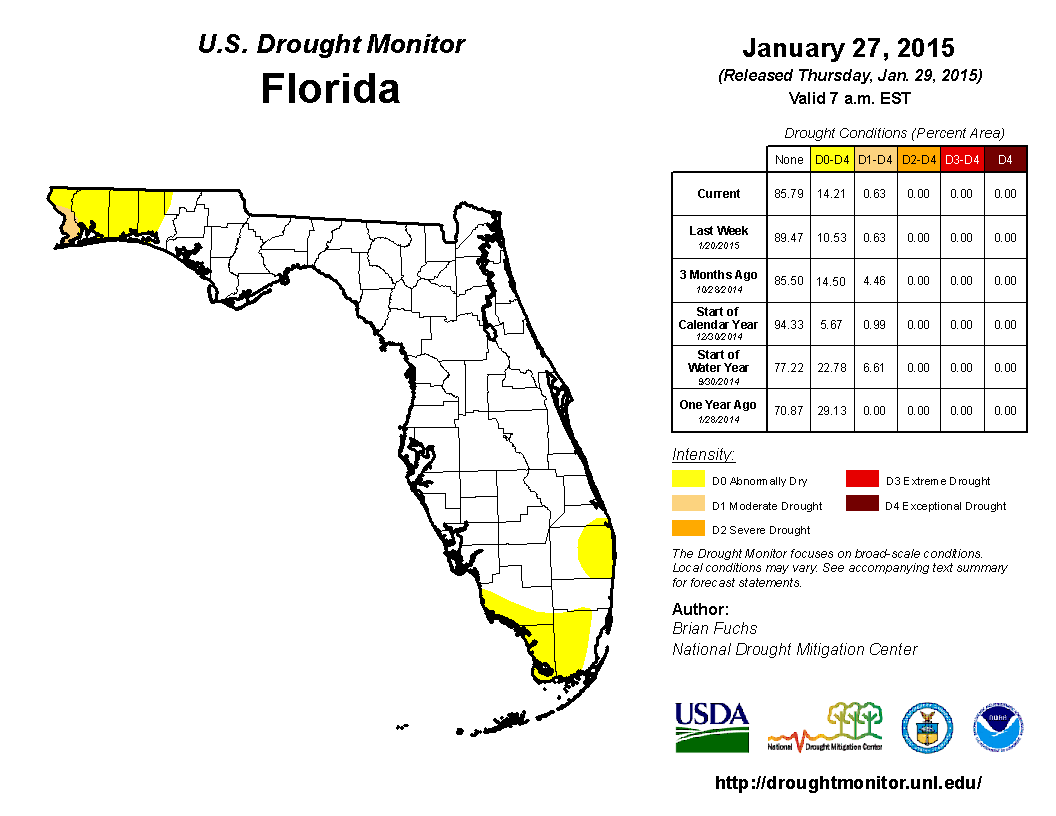
Current State of the Drought
The beginning of the year started off with portions of the Florida Panhandle recovering from above average rainfall, while the rest of the state was below normal. As January progressed, widespread rain moved through the northern part of the state from the 4th - 5th, with the majority of the rainfall north of the Gainesville area. With the exception of some very localized light rain, the state remained dry until 12th, when a low-pressure system moved through, dropping over an inch of rainfall in central Florida. Drought conditions remained consistent in the Northwest Panhandle with abnormally dry (D0) conditions in Escambia, Santa Rosa, Okaloosa and Walton. However, the lack of rain in South Florida over the last 3 months lead to the introduction of D0 in Dade and Monroe counties by the middle of January. Two more rain events impacted the state- one of the 16th, which brought rain only to the Panhandle, and heavy rain was reported with the second event as it pushed through North Florida and parts of the Peninsula on the 23rd and 24th. However, the region surrounding Lake Okeechobee remained rain-free through the end of the month, promoting the expansion of D0 into Collier and Palm Beach counties.
|
Odds and Ends
Make sure to check out the monthly Wx Talk Webinars offered by CoCoRaHS. Each month features a different weather related topic and gives a chance for our observers to interact with the speaker. If you are unable to attend or have missed some of the previous month's talks, you can find them archived on the CoCoRaHS YouTube site: http://www.youtube.com/cocorahs/
Make sure to like Florida CoCoRaHS on Facebook! Observers can now post comments and pictures to the wall.
|
|
|
|
 |
 |
 |
 |
 |
 |
 |
 |
 |
 |
 |
 |
 |
|
|
 |
 |
|
 |
|