Dear Florida Climate Center Friends,
We'd like to present you with the September 2014 edition of our newsletter. In this newsletter, you'll find our monthly climate summary, a list of special events that our staff attended, some pictures, and more. If you have any questions, please email us at climate@coaps.fsu.edu.
Thanks,
The Staff of the Florida Climate Center
 |  |  | David Zierden
State Climatologist | James O'Brien
Professor Emeritus | Melissa Griffin
Asst. State Climatologist |
|
August Climate Summary for Florida
The Florida Climate Center's August 2014 Florida Climate Summary is now available. The summary provides an analysis of temperature and precipitation trends across the state, along with data on hazardous weather, drought, the impacts of the weather and any records tied or broken for the month. During August, average temperatures were above normal and rainfall totals were below normal for most of Florida. ENSO-neutral conditions are continuing in the equatorial Pacific. The Climate Prediction Center (CPC) predicts above normal temperatures for northeast portions of the state and above normal precipitation for the southern Peninsula through November. Past summaries are archived here.
| August average temperatures and departures from normal (°F) for select cities. | 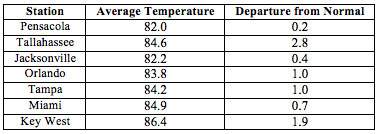 |
| August precipitation totals and departures from normal (°F) for select cities. | 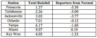 |
| A graphical depiction of the monthly rainfall departure from normal (inches) for August(courtesy of NOAA, NWS). | 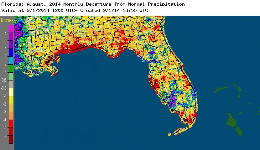 |
|
|
Summer 2014 Rainfall - Tale of Two Cities
Rainfall this summer (June through August) has been highly variable across Florida. Nowhere is this illustrated more convincingly than by looking at rainfall totals for two cities, Tallahassee and Miami.
Tallahassee set the record for the driest summer (June through August) ever with a total of only 8.99 inches. The previous record was 10.89 inches set in 2011, while the second lowest total was 10.94 inches in 1918. What is remarkable is that in spite of the very low rainfall totals, the Tallahassee area has actually seen fairly frequent showers. The Tallahassee airport recorded 37 days with measurable precipitation since June 1st, a frequency of every third day! The frequent small amounts of rain combined with a very wet spring has let the North Florida area withstand the summer dryness without too much impact on crops or water resources...so far.
However, Miami is a different story. Miami International Airport's total for the three months since June 1st stands at 38.98 inches, nearly an inch below the 1995 record of 39.92 inches. Also remarkable is that this year's total has not been directly impacted by any tropical storms or systems. The three month total makes 2014 the second wettest summer on record.
Overall, North Florida is drying out and abnormally dry conditions (D0 according to the U.S. Drought Monitor) are spreading across north Florida and the Panhandle. The peninsula from Gainesville southward has enjoyed a normal to above rainy season.
|
|
FSU Undergraduate Returns From Research Trip 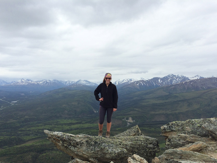
Ms. Lauren Zuromski, an undergraduate research assistant at the Florida Climate Center, returned from her summer internship at the Arctic Climate Center in Fairbanks, Alaska.
As part of her NOAA Ernest F. Hollings Scholarship, Ms. Zuromski used reanalysis tools, along with archived storm reports and newspaper articles to summarize and analyze several important weather events in Alaska. Over the next two semesters, Ms. Zuromski will be completing her Honors in the Major Project, which is exploring the use of analog data as a communication tool about climate change.
|
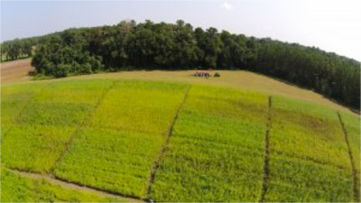 Row Crop Group Meeting
The Tri-state Climate Working Group for Row Crop Farmers held its ninth meeting on August 7th in Live Oak, Florida. The group is sponsored by the Southeast Climate Consortium and brings together university researchers, extension specialists, county agents, and growers to explore the use of climate information and forecasts in making their operations more resilient to climate variation.
Elena Toro, from Suwannee County Extension, led off the meeting with an overview of sesame production in the area and how the crop is well suited for the warm, moist, and variable climate of the region. The group then toured the experimental fields at the Suwannee Valley Agricultural Extension Center. In the fields, Mace Bauer demonstrated how unmanned aerial vehicle (drone) technology can be used to survey fields for water stress and disease.
Florida State Climatologist David Zierden closed the meeting with a summary of weather conditions to date this growing season and an outlook of what can be expected the remainder of the summer and fall. He explained how El Niño is less likely to develop now than forecasted earlier this year and that it would be relatively weak if it did develop. The group also heard from special guest Ed Mansouri about the WeatherSTEM project, linking weather observations and science with farms, and schools in Madison County.
|
|
Upcoming Events
September 3-5, 2014:
Southern Region Extension Climate Academy in Athens, GA
November 19-21, 2014:
Fall Review of the Southeast Climate Consortium in Auburn, AL
January 4-9, 2015:
Annual Meeting of the American Meteorological Society in Phoenix, AZ
|
|
Example Data Request: Storm Data
Each month, we highlight here recent examples of some of the many public services provided by the Florida Climate Center:
"What was the weather like in Lakeland on March 15, 1983?"
The Florida Climate Center gets requests, similar to the one above, from people asking about what the weather was like on a certain day- most of the time it's about the day they were born. While they are interested in the maximum and minimum temperature, often they want more information. They are looking for interesting weather events, such as a hail storm that could have caused significant damage, a hurricane that may have impacted the area, or a deep freeze that left people wishing for summer.
Using storm event data, compiled by the National Climatic Data Center, along with information and narratives found in our archives, the Florida Climate Center can easily answer these questions.
These requests have also spawned the new addition to our Facebook page, 'This Day in Florida Weather History.' Each day, a storm event from the past, whether it was last year or 50 years ago, is posted to the page. If you're interested in learning a little bit about historical weather events in Florida, 'Like' us on Facebook.
|
|
About Us
The Florida Climate Center is part of a three-tiered system of national, regional, and state climate offices, including NOAA's National Climatic Data Center and the Southeast Regional Climate Center. The Florida State Climatologist and other staff at the Florida Climate Center provide the following information and services to the people of Florida:
· Climate Data:
Historical weather observations for weather stations throughout the state of Florida. We are able to provide data for most stations from 1948-present.
· Climate Information:
Long-term historical averages for various stations, climate divisions, and the entire state.
· Extreme Event Records:
Information and analyses on extreme events such as freezes, droughts, floods and hurricanes.
· Special Analysis:
With their vast knowledge of El Niño, La Niña and climate variability, the State Climatologist and staff can offer expert insight into Florida's climate trends.
· Outreach:
Activities, presentations, and workshops that inform and educate the people of Florida about current and emerging climate issues. We also coordinate volunteers for the Community Collaborative Rain, Hail & Snow Network (CoCoRaHS).
More About Us
|
|


