 |
|
CoCoRaHS
F L O R I D A
A Community Collaborative
Rain, Hail & Snow Network
|
|
|
|
 |
 |
 |
 |
 |
 |
 |
 |
 |
 |
 |
 |
 |
I ushered in the New Year with family in Tennessee, taking a break from our typical Florida winters and enjoying the cooler temperatures. One evening, as we went to look at Christmas lights, we encountered snow showers. Having grown up in the Mid-Atlantic, I'm not a stranger to snow, but I couldn't help but feel like a little kid again as I frolicked in a mall parking lot with my daughter amidst the flurries.
One of the neat applications that I have on my phone came in handy while we were out that evening. It's called mPING, a project between the National Severe Storms Laboratory (NSSL), the University of Oklahoma, and the Cooperative Institute for Mesoscale Meteorological Studies. With this free app, you can report the precipitation type at your location with just a few taps. My daughter had fun 'pinging' snow as we cruised around the Nashville area. You can find more information about the app, at the NSSL website: http://www.nssl.noaa.gov/projects/ping/
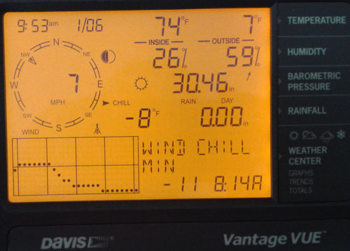
The morning of January 6th, we woke up not only to snow and ice coating everything but also to dangerously cold temperatures and wind chills in Tennessee. At 10am, it was only 7˚F and the wind chill was -10˚F. In Illinois, my friend and State Climatologist Jim Angel took this amazing picture of a sundog, with a temperature of -12˚F.
 
While this bitterly cold air mass is not expected to make temperatures dip into the single digits in Florida, parts of the state will see some of the coldest air of the season, and wind chill advisories and hard freeze warnings have been issued across the state.
|
Quick Facts About December Observations
Registered Observers:
| 1,337 | Active Observers:
| 485 | Reports Submitted:
| 12,091 | Date of Most Reports:
| 411 on the 15th | Highest Rain Report:
| 6.23 on the 15th (FL-LV-1) |
|
December Rains
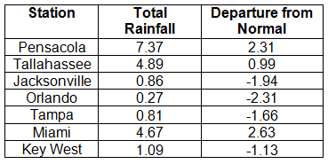
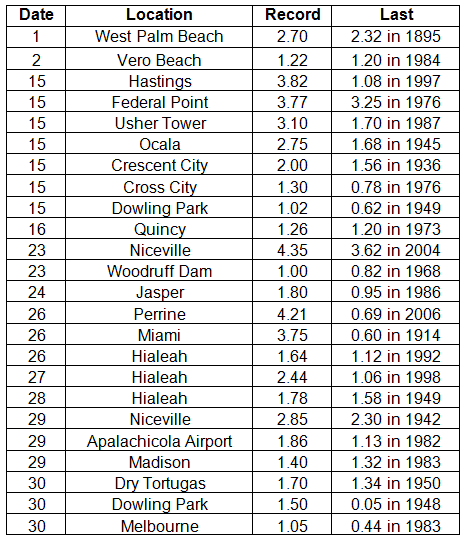
Portions of the Big Bend, Panhandle, north-central Florid,a and areas around Miami reported monthly rainfall totals above normal, while the majority of the Peninsula saw below normal totals (Figure 1). Departures from normal roughly ranged from -2.31" to 2.63" (Table 1), though some areas of Florida saw rainfall totals that were as much as 3.00" below normal or nearly 8.00" above normal. December 2013 was the 6th wettest December on record in Miami, while it was the 6th driest in Orlando. Numerous 24-hour precipitation records were broken for the month (Table 2).
Table 1. December precipitation totals and departures from normal (inches) for selected cities.

Table 2. Select daily rainfall records (inches) broken during December (Compiled from NOAA, NWS)

Figure 1. A graphical depiction of the monthly rainfall departure from normal (inches) for December is given in the figure below (courtesy of NOAA, NWS).
|
December CoCoRaHS Totals
Here are the CoCoRaHS rainfall totals for December from some select CoCoRaHS stations across the state.
|
2013 Rainfall Report
Rainfall totals from 2013 varied across Florida. Niceville had an impressive 91.59" in 2013, which was over 20" above normal, while places like Jacksonville, Orlando, Melbourne, and St. Petersburg reported below normal rainfall for the year.
|
Current State of the Drought
Early in December, there was an expansion of dry conditions (D0) in south Florida to include portions of Collier and Lee counties. The lack of rain in the beginning of December caused the introduction of D0 into the northwest Panhandle (Escambia, Santa Rosa and Okaloosa counties) and in part of central Florida (Orange, Osceola, Seminole and Volusia counties). However, rain in the northeastern portion of the state alleviated some of the dryness around the areas of Jacksonville, St. Augustine, Ocala, and Gainesville. Some residual dryness remained in Nassau, Baker, Columbia, and Hamilton counties by the end of the month, with D0 conditions still present along portions of the east coast and citrus growing region. The CPC forecast for the next three-months (January, February, and March) is predicting below normal rainfall, so the chance of seeing more dry conditions, and potentially drought, introduced into the state remains high.
|
Odds and Ends
I continue to appreciate how understanding you observers are when you are contacted by someone at CoCoHQ or myself about a flagged rainfall value, and with how quick they were to reply to with validation or corrected totals. Please remember if you receive an email from me with the subject line 'Question About Your Recent CoCoRaHS Observation', please take a moment to answer me back. And if you have any questions, please feel free to contact me.
Make sure to check out the monthly Wx Talk Webinars offered by CoCoRaHS. Each month features a different weather related topic and gives a chance for our observers to interact with the speaker. If you are unable to attend or have missed some of the previous month's talks, you can find them archived on the CoCoRaHS YouTube site: http://www.youtube.com/cocorahs/
Make sure to like Florida CoCoRaHS on Facebook! Observers can now post comments and pictures to the wall.
|
|
|
|
 |
 |
 |
 |
 |
 |
 |
 |
 |
 |
 |
 |
 |
|
|
 |
 |
|
 |
|