 |
|
CoCoRaHS
F L O R I D A
A Community Collaborative
Rain, Hail & Snow Network
|
|
|
|
 |
 |
 |
 |
 |
 |
 |
 |
 |
 |
 |
 |
 |
I'd like to start out this last newsletter of 2013 by wishing you all a Happy Holiday season and a Happy New Year. I appreciate your continued willingness to be part of the program as we move into our 7th year of CoCoRaHS in Florida. And as we get ready to embark on a new year, you may have noticed that we've changed up the format and layout of the newsletter, just a little bit.
The official start to winter is Dec 21st and the days will become shorter, which means checking your rain gauge in the dark. Please make sure to watch where you step as you make your morning readings. I got my first real 'taste' of winter over Thanksgiving, where I woke up to 11˚F one morning, and was out shopping in a wintry mix of snow, sleet and rain another day. It was a definite change from this time last year when I was still wearing flip-flops.
|
Quick Facts About November Observations
Registered Observers:
| 1,331 | Active Observers:
| 500 | Reports Submitted:
| 11,939 | Date of Most Reports:
| 415 on the 16th | Highest Rain Report:
| 7.46 on the 27th (FL-JF-3) |
|
Winter 2013-2014 Outlook
Weather patterns this year for the upcoming winter are prone to be more variable, with swings between warmer, colder, wetter, and drier periods throughout the season. The reason is that the Pacific Ocean is currently in the neutral phase; meaning sea surface temperatures near the equator in eastern and central Pacific Ocean are close to normal. Winter weather and climate patterns in Florida and the Southeast are heavily influenced by the El Ni�o/La Ni�a cycle, where ocean temperatures in the tropical Pacific swing between warmer than normal and colder than normal every 2 to 7 years.
With neither El Ni�o nor La Ni�a in place this year, the jet streams are freer to meander over North America, leading to greater variability in temperature and rainfall from week to week. When looking at the winter as a whole, the seasonal temperature and rainfall is likely to be close to normal. Instead of the odds being heavily tipped towards wetter and colder or drier and warmer, all possibilities are equally likely in a neutral winter. These more variable weather patterns mean there will be periods of very cold weather mixed with warm spells. This variable pattern will hopefully provide near-normal rainfall for the state. Remember, that the winter is a critical recharge period for surface and groundwater in Alabama, Georgia and Florida.
|
2013 Hurricane Season Review
November 30th marked the official end to the 2013 Hurricane Season. This hurricane season had the fewest number of hurricanes since 1982, with only 13 named storms. Only two of those (Ingrid and Humberto) became hurricanes, and only one storm (Tropical Storm Andrea) made landfall in the U.S. The forecasts at the beginning of the season predicted a very active season, but the number of actual hurricanes and major hurricanes were well below normal.
To find out more about the season, you can read the official press release from NOAA at:
http://www.noaanews.noaa.gov/stories2013/20131125_endofhurricaneseason.html
In addition, the National Hurricane Center will be putting together Tropical Cyclone Reports for all of the 2013 storms. Once they have finalized an in-depth report on an individual storm, it will be posted on the following website:
http://www.nhc.noaa.gov/2013atlan.shtml
|
November Rains
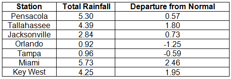
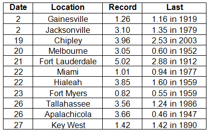
Portions of the Big Bend, North Florida and areas along the southeast coast and Florida Keys reported monthly rainfall totals above normal, while extreme northwest Florida and most of the southern Peninsula saw below normal totals (Figure 1). Departures from normal roughly ranged from -0.59" to 7.68" (Table 1), though some areas Florida saw rainfall totals that were as much as 5.00" below normal or nearly 8.00" above normal. November 2013 was the 4th wettest November on record in Fort Lauderdale, 7th wettest in Chipley, and the 10th wettest in Miami. Numerous 24-hour precipitation records were broken for the month (Table 2), including one record that was tied that dates back to 1890 in Key West.
Table 1. November precipitation totals and departures from normal (inches) for selected cities.

Table 2. Select daily rainfall records (inches) broken during November (Compiled from NOAA, NWS)

Figure 1. A graphical depiction of the monthly rainfall departure from normal (inches) for November is given in the figure below (courtesy of NOAA, NWS).
|
November CoCoRaHS Totals
Here are the CoCoRaHS rainfall totals for November from some select CoCoRaHS stations across the state.
|
Current State of the Drought
When the Drought Monitor was released on the 5th of November, the dryness from the previous week's map (October 29th) had expanded and was reported along the Gold Coast and Monroe County, including the Florida Keys. By November 19th, all of the counties on the East Coast were reporting abnormally dry (D0) conditions. The D0 was also recorded in and around Lake Okeechobee, and in portions of northern Escambia County. Rains in South Florida between the 19th and 26th eased the dryness along the immediate East Coast from Indian River through the Florida Keys. Throughout the entire month, the D0 conditions in North Florida were present, and even above normal rainfall for November in some of the area was not enough to ease drought concerns in that portion of the state. The CPC forecast for the next three-months is predicting below normal rainfall, so the chance of seeing more dry conditions, and potentially drought, introduced into the state remains high.
|
Odds and Ends
I continue to appreciate how understanding you observers are when you are contacted by someone at CoCoHQ or myself about a flagged rainfall value, and with how quick they were to reply to with validation or corrected totals. Please remember if you receive an email from me with the subject line 'Question About Your Recent CoCoRaHS Observation', please take a moment to answer me back. And if you have any questions, please feel free to contact me.
Make sure to check out the monthly Wx Talk Webinars offered by CoCoRaHS. Each month features a different weather related topic and gives a chance for our observers to interact with the speaker. If you are unable to attend or have missed some of the previous month's talks, you can find them archived on the CoCoRaHS YouTube site: http://www.youtube.com/cocorahs/
Make sure to like Florida CoCoRaHS on Facebook! Observers can now post comments and pictures to the wall.
|
|
|
|
 |
 |
 |
 |
 |
 |
 |
 |
 |
 |
 |
 |
 |
|
|
 |
 |
|
 |
|