| Quick Facts | |
1,324 Registered FL Observers
500 Active FL Observers
12,256 FL Reports Submitted during October
Greatest # of Daily Reports Submitted during October: 437 on 10/8/13
Most Rainfall Reported during October: 5.27" on 10/3/13 from Station FL-MD-30
|
|
|
|
'Fall Back' This Weekend
| |
This weekend marks the end of Daylight Saving Time. Make sure that you turn your clocks back one hour before heading to bed on Saturday night! As an observer, you do not need to adjust when you go and read your rain gauge. If you've been reporting at 7:00 AM, then continue to report at 7:00 AM.
|
|
Observer 5-Year Service Awards
|
After a few weeks of working on the awards, all 95 of them are ready to be emailed out to observers. To save the cost of postage and paper, I will be emailing PDF copies of the award certificates to Florida CoCoRaHS members who have been part of the program since 2008.
I would like to thank you (once again!) for all of the dedication you've given this project. Each year, there is a significant weather event that shows how our little network of 15,000+ observers has helped out by providing additional rainfall data on a daily basis. So, take a moment and pat yourself on the back!
|
|
Tropical Storm Karen and Beach Therapy
|
At the end of September, an area of disturbed weather formed in the Southwest Caribbean Sea, moved through the Yucatan Channel and formed into Tropical Storm Karen on the 3rd of October. The forecasting models initially had Karen strengthening into a hurricane, but strong shear and dry air weakened the storm and it deteriorated to tropical depression on the 6th. While Karen threatened the Florida Gulf Coast, the storm caused increased wave heights and dangerous rip currents along north Florida. Many beaches posted double red flags, meaning that water was closed to the public.
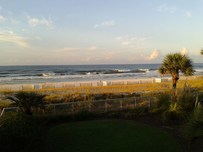 | | Rough surf along Fort Walton Beach on October 5th |
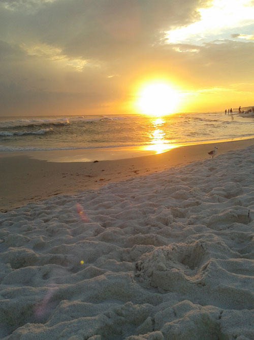
Now, you may be asking how this ties in with 'Beach Therapy.' Every October, I take an extended weekend and head down to one of my favorite places in Florida to celebrate my birthday with friends: Fort Walton Beach. However, this year, Karen had other plans and I had a limited window to soak my toes in the warm waters of the Gulf before saying goodbye to summer. And while Karen may have hampered my beach plans, the storm did provide some fantastic sunsets.
|
|
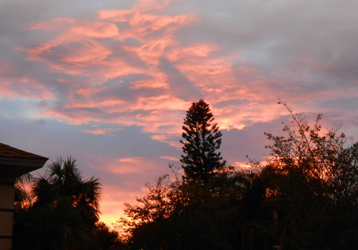
Observer Photo
|
And speaking of sunsets, Roger (FL-SS-10) sent me this gorgeous September sunset from his house. Roger says, "We do not get sunset scenes very often. We are inland, and surrounded by houses and trees. This blocks out most of the sunset effects, which tend to be near the horizon. September 17 was an exception. These high clouds reflected the colors from the sun, which had already gone beneath our view. I walked out of the house at just the right time."
|
|
October Rains
|
There were a few pockets of near normal or slightly above normal rainfall (Flagler County) for October; but on a whole, rainfall totals across the state were below normal for the month (Figure 1). Departures from normal roughly ranged from 0.54" to -3.89" (Table 1), though areas along the eastern coast of Florida saw rainfall totals that were as much as 5.00" below normal. October 2013 was the 2nd driest October on records for Orlando and Melbourne, the 3rd driest for Gainesville and West Palm Beach, 4th driest for Vero Beach and the 7th driest for Naples. Numerous 24-hour precipitation records were broken for the month (Table 2).
| Table 1: October precipitation totals and departures from normal (inches) for select cities. | 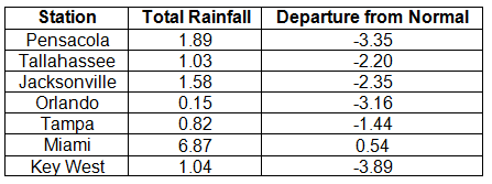 |
| Table 2. Select daily rainfall records (inches) broken during October (compiled from NOAA, NWS). | 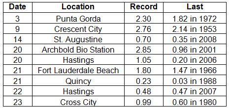 |
|
|
Figure 1. A graphical depiction of the monthly rainfall departure from normal (inches) for October is given in the figure below (courtesy of NOAA, NWS).
| 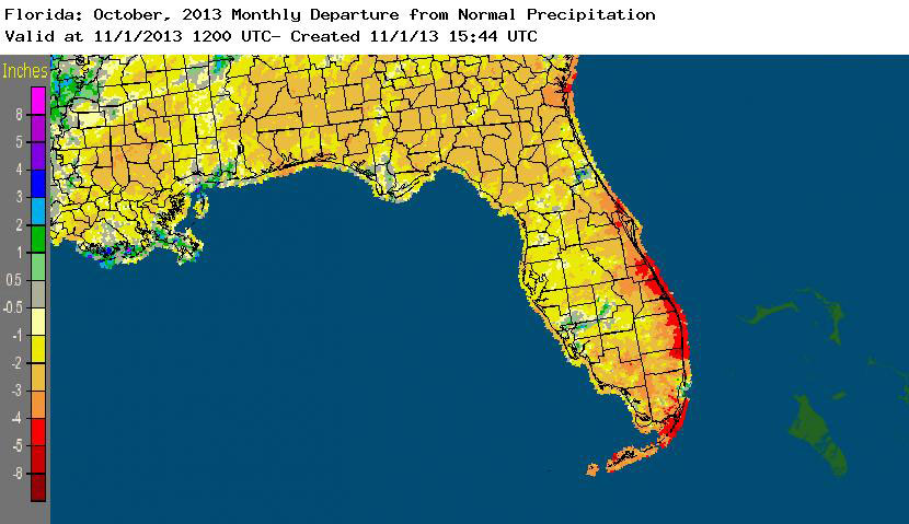 |
|
|
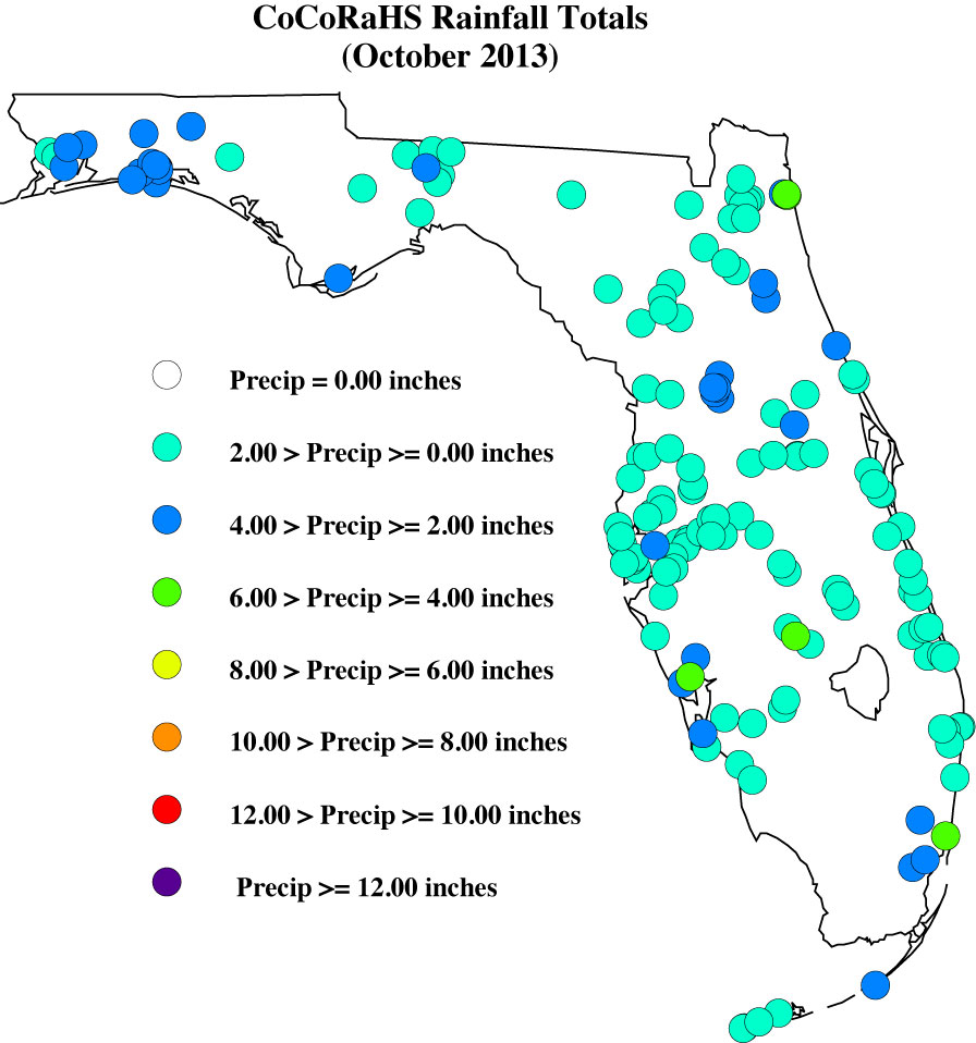
October CoCoRaHS Totals
|
Here are the CoCoRaHS rainfall totals for October from some select CoCoRaHS stations across the state.
|
|
Current State of the Drought
|
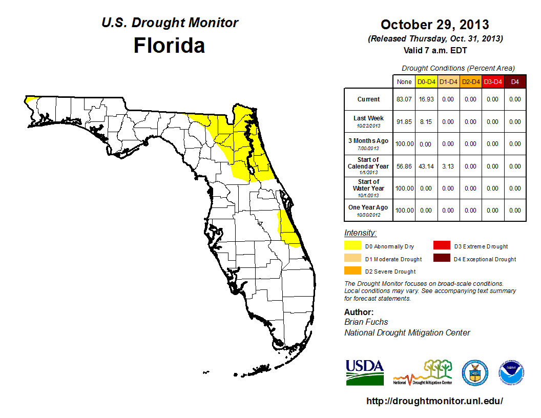
The combined below normal rainfall totals in September and October prompted the reintroduction of dry conditions (D0) toward the end of October. The D0 conditions were first indentified in northeast Florida, around Jacksonville, St. Augustine, Glen St. Mary, Lake City and Orange Park. When the Drought Monitor was released on the 29th, the D0 category had doubled in spatial area and included all of Indian River County, portions of southern Brevard County and northwestern Escambia County. Statewide, normal November rainfall totals range from a low of 1.45" (Naples and Royal Palm Ranger Station) to a high of 5.40" (Niceville). Despite the lack of rainfall, Lake Okeechobee is reporting a lake water level of 15.23' (as of November 1st) and South Florida water levels are well positioned for the start of the dry season. One month remains in the 2013 Hurricane Season, but any storms that form typically track away from Florida. The CPC forecast for the next three-months is predicting below normal rainfall, so the chance of seeing more dry conditions, and potentially drought, introduced into the state remains high.
The National Drought Monitor is updated weekly, so you can always check the most recent conditions here:
http://www.drought.unl.edu/dm/DM_state.htm?FL,SE.
|
|
|
Odds and Ends
|
I continue to appreciate how understanding you observers are when you are contacted by someone at CoCoHQ or myself about a flagged rainfall value, and how quick you reply with validation or corrected totals. Please remember: if you receive an email from me with the subject line 'Question About Your Recent CoCoRaHS Observation', please take a moment to answer me back. And if you have any questions, please feel free to contact me.
Make sure to check out the monthly WxTalk Webinars offered by CoCoRaHS. Each month features a different weather-related topic and gives a chance for our observers to interact with the speaker. If you are unable to attend or have missed some of the previous month's talks, you can find them archived on the CoCoRaHS YouTube site: http://www.youtube.com/cocorahs/
Make sure to like 'Florida CoCoRaHS' on Facebook! Observers can now post comments and pictures to the wall.
| |
|
Thank You!
Thank you for your continued support and enthusiasm! If at any time you have questions about CoCoRaHS, reading your rain gauge, or finding a location to setup your rain gauge, please feel to contact a Florida CoCoRaHS Coordinator. We are lucky enough to have regional support from National Weather Service offices across the state, as well as county/local help from several CoCoRaHS volunteers.
 Melissa Griffin Florida CoCoRaHS State Coordinator Assistant State Climatologist Florida Climate Center/Center for Ocean-Atmospheric Prediction Studies Florida State University Tallahassee, FL 32306-2741 (850) 644-0719 griffin@coaps.fsu.edu | |
|