| Quick Facts | |
1,249 Registered FL Observers
469 Active FL Observers
11,027 FL Reports Submitted during 11/12
Greatest # of Daily Reports Submitted during November: 391 on 11/7/12
Most Rainfall Reported during November: 4.38" on 11/17/12 from Station FL-MT-7
|
|
|
|
Happy Holidays! |
The official start to winter is Dec 21st (the winter solstice). Some of you may be checking your rain gauges in the dark, so please make sure to watch where you step as you make your morning readings. While winter may be fast approaching, we can't always tell by the weather. It was a bit surreal attending a local outdoor shopping event this weekend and wearing flip-flops. Even after 15 years in the state, this non-native still can't get used to the idea of shorts in December.
We appreciate your continued willingness to help be a part of the program. 2012 was another perfect example of all the benefits that came out of your participation. So, once again, I thank you. |
|
Winter 2012-2013 Outlook |
After two years of La Niña conditions, the sea surface temperatures have returned to near normal, meaning that Neutral conditions are expected to hold during the 2012-2013 winter. I know what you're asking... What does that mean?
If the Neutral conditions continue through December, January and February, it means that the weather patterns across the U.S will be more variable. These more variable weather patterns mean there will be periods of very cold weather mixed with warm spells. Severe freezes that can impact citrus and other winter crops are more likely this year. Studies have shown that of the dozen or so catastrophic freezes that have impacted the Florida citrus industry since the late 1800's, nearly all of them have happened during winters with Neutral conditions. This variable pattern will hopefully provide near-normal rainfall for the state. Remember that the winter is a critical recharge period for surface and groundwater in Alabama, Georgia and Florida.
|
|
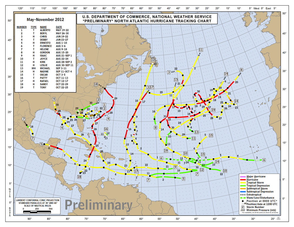
Hurricane Season 2012 Ends |
November 30th marked the official end to the 2012 Hurricane Season. This makes the 7th consecutive year that no major hurricane made landfall in the U.S., but this year will be remembered by Isaac and Sandy. The Mid-Atlantic and the Northeast have been impacted two years in a row, with Irene in 2011 and Sandy this year. Here is a quick overview of the 2012 season:
- 19 Named Storms - 10 Hurricanes, 1 Major Hurricane
- Two storms were named in May, before the official start of the season.
- Florida was impacted by the following storms: TS Alberto, TS Beryl, TS Debby, Hurricane Isaac and Hurricane Sandy.
To find out more about the season, you can read the official press release from NOAA.
In addition, the National Hurricane Center will be putting together Tropical Cyclone Reports for all of the 2012 storms. Once they have finalized these in-depth reports on an individual storm, it will be posted here.
|
|
November Rains |
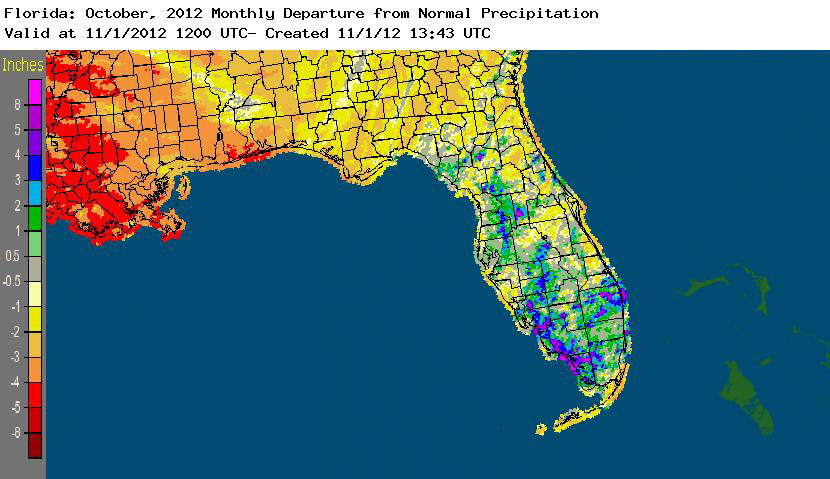
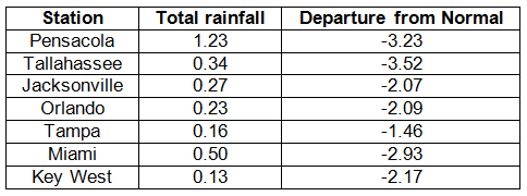
Rainfall totals across the state were well below normal this month (Table 1), with departures ranging from -1.46" at Tampa to -3.52" in Tallahassee. The late fall to early spring is typically the second wet season for the northern part of the state, and rainfall totals from November reflect the lack of these 'winter rains'. November 2012 was the 4th driest November on record at Tallahassee. The dry conditions across the state (Figure 1), especially in the Panhandle and Northeast Florida, prompted the National Drought Monitor to reintroduce drought designations for portions of the state. Due to the fact there were only 9 precipitation records broken in November, and only one of them was over 0.50", they will not be highlighted this month.
| Table 1: November precipitation totals and departures from normal (inches) for select cities. |
|  |
|
Figure 1. A graphical depiction of the monthly rainfall departure from normal (inches) for November is given in the figure below (courtesy of NOAA, NWS). | 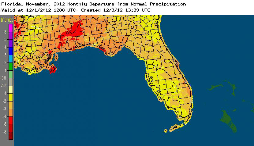 |
|
|
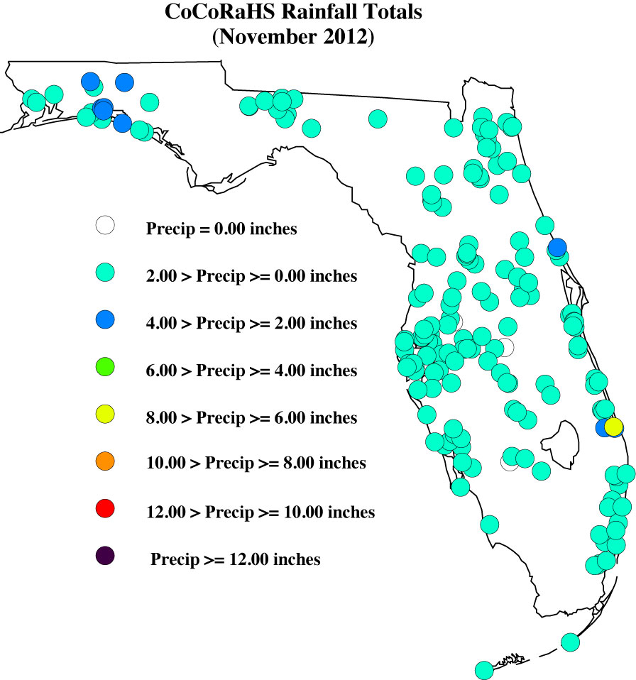
November CoCoRaHS Totals |
Here are the CoCoRaHS rainfall totals for November from some select CoCoRaHS stations across the state.
|
|
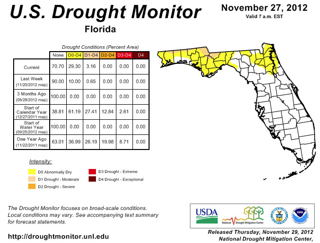
Current State of the Drought |
The week after the October Climate Summary was released, the authors of the National Drought Monitor, with insight from a variety of contributors, decided to start adding the 'dry conditions' designation back to Florida. After about 2 months of being drought free, parts of Northern Leon, Gadsden, Walton, and Holmes counties saw a reintroduction of dry conditions as the drought in Georgia and southeastern Alabama spread across the state line. By the 13th, all of the northern parts of Panhandle counties that share a border with Alabama or Georgia were labeled dry. And as the dry month persisted, and with little to no rain falling over these already dry areas, moderate drought was introduced back into the state by the end of the month. Portions of central and south Florida remained drought free during November, as the fall and winter months are usually drier than the northern tier of the state.
The National Drought Monitor is updated weekly, so you can always check the most recent conditions here:
http://www.drought.unl.edu/dm/DM_state.htm?FL,SE.
|
|
|
Odds and Ends |
A few reports in Florida were flagged and required some additional information during November. I appreciate how understanding the contacted observers were, along with how quick they were to reply to my emails, though there are a few outstanding issues that need to be resolved. Please remember if you receive an email from me with the subject line 'Question About Your Recent CoCoRaHS Observation', please take a moment to answer me back. And if you have any questions, please feel free to contact me.
You can now 'Like' Florida CoCoRaHS on Facebook! By joining our Facebook page, the latest Florida CoCoRaHS news items will automatically show up in your "news feed" when you first login to Facebook. To join, click the "Find us on Facebook" link in the menu bar of this email, then click the "like" button on our Facebook page.
Make sure to check out the monthly WxTalk Webinars offered by CoCoRaHS. Each month features a different weather-related topic and gives a chance for our observers to interact with the speaker. If you are unable to attend or have missed some of the previous month's talks, you can find them archived on the CoCoRaHS YouTube site: http://www.youtube.com/cocorahs/ | |
|
Thank You!
Thank you for your continued support and enthusiasm! If at any time you have questions about CoCoRaHS, reading your rain gauge, or finding a location to setup your rain gauge, please feel to contact a Florida CoCoRaHS Coordinator. We are lucky enough to have regional support from National Weather Service offices across the state, as well as county/local help from several CoCoRaHS volunteers.
 Melissa Griffin Florida CoCoRaHS State Coordinator Assistant State Climatologist Florida Climate Center/Center for Ocean-Atmospheric Prediction Studies Florida State University 232 R.M. Johnson Building Tallahassee, FL 32306-2840 (850) 644-0719 griffin@coaps.fsu.edu | |
|