|
|
|
|
|
|
|
Volume 3 #2 February 2012
|
www.assist-us.com
|
Greetings!
Our market research and contacts with clients and prospects during the past 22 months have revealed multiple applications for aerial data acquisition and analysis services.
This month, Bruce Seibert describes how our collection of aerial imagery can benefit the country's growing reliance on railroad transportation. Long neglected due to low fuel prices and alternative means of transport, the national railroad infrastructure needs new and efficient methods of "TLC."
Timely aerial data acquisition -- whether streaming video or still images -- can cost-effectively supplement the more costly ground surveillance methods traditionally used to perform maintenance of our railroads.
The following article describes how the nation's railroad system can benefit significantly from the use of aerial data acquisition and analysis services. Be sure to view the video that showcases the benefits of full motion video imagery for railroads at the end of the article.
Thanks for your continued interest.
Gerry Kobelski, CEO
|
|
Safety and Security Applications of Aerial Imagery Services for the Railroad Industry
| |
Background and History
Due to the development of the Interstate Highway System, the Railroad Industry was rendered nearly obsolete after more than a century of dominating the overland commercial transportation industry from 1850 to 1958.
Modeled on Germany's Autobahns, the "Interstates" connected all major American cities with a network of limited access, high-speed roadways. The trucking industry flourished with the post-WII production of modern trucks and cheap diesel fuel. Passenger trains were replaced by comfortable, inexpensive bus transportation. Railroads declined through the 1960s and '70s. Rail freight loads were down as trucks carried the bulk of our cargoes. Railroad tracks fell into disrepair and many were taken up as lines were abandoned due to factory closings as industry evolved. Few railroads could continue to operate without government subsidies; they were just unprofitable.
Then along came the energy crisis of 1973 and a new social movement-environmentalism. Fuel shortages drove costs ever higher as inefficient truck engines belched black smoke, creating smog-obscured city skylines. New government regulations mandated expensive, new, fuel-efficient engine designs and emissions standards for all motor vehicles. This may have saved the railroads, as new diesel locomotives made trains more efficient than large fleets of trucks for moving freight. Trains once again became an affordable alternative for commuters who lived in the suburbs but worked in the cities.
The nuclear accident at 3-Mile Island, Pennsylvania, in 1979 halted the production of new nuclear power plants. When the OPEC nations imposed a second oil embargo, endless miles of coal trains supplied fuel to conventional power plants across the nation, helping to stabilize energy costs. Then, along with new investment and government subsidies for updating and maintaining tracks, improved locomotive technology and specialty car designs began to return commercial railroading to profitability, at least as a freight carrier. Today, railroading is once again finding favor with the public by reducing highway traffic congestion and lowering overall hydro-carbon emissions. It is also seen as an alternative to the inconveniences of air travel.
|
|
Continuous Track Maintenance and Safety Surveys
| |
Railroad tracks that support exceedingly heavy and dynamic loads are subject to wear, damage, and degradation by exposure to the elements.
They are also subject to encroachment by vegetation and roadbed erosion where they follow streams or rivers, or after heavy rains, as happened during Hurricane Irene last year.

Active fault lines in the earth can bend rails, and earthquakes alter their paths. Tracks require continuous active surveillance and maintenance, mostly performed by small crews in rail riding pick-up trucks with bumper-mounted video cameras. Most tracks are surveyed several times a year, at great expense.
There is a more efficient way to perform some of these tasks.
|
Railroad Security Considerations | |
In this post-9/11 world, transportation services are subject to careful scrutiny, with an entire government administration dedicated to preventing terrorist attacks. Aviation is a priority, with an emphasis on the screening of passengers and their luggage prior to boarding, because aircraft were transformed into guided missiles by terrorists on that day in 2001.
But as we saw in Spain on March 11, 2004, and in the London Subway bombings on July 7, 2005, trains and their stations make "soft targets" (relatively vulnerable and easy to hit). A small, well-placed, improvised explosive device (IED) on a railroad track will cause a train wreck. Add speed and/or hazardous cargoes in a populated area, and you have a major disaster zone requiring evacuation.
 Railroad trains, properties, rights of way, bridges and trestles are all vulnerable to trespass, theft, vandalism and terrorist assault. They require constant surveillance, performed mainly by a dedicated railroad police force. But their reach is short and mainly involves post-event investigations, inspections, and theft prevention. Railroad trains, properties, rights of way, bridges and trestles are all vulnerable to trespass, theft, vandalism and terrorist assault. They require constant surveillance, performed mainly by a dedicated railroad police force. But their reach is short and mainly involves post-event investigations, inspections, and theft prevention.
There is a more effective solution for mitigating railroad vulnerability and improving security.
|
|
Active Aerial Surveillance for Railway Safety and Security Inspection
|
Safety
| |
Aerial data acquisition (ADA) procedures, the domestic application of aerial surveillance capabilities and techniques used by the military in the Iraq and Afghanistan wars, have been revolutionized over the last decade.
Along with the miniaturization and commercial availability of next generation cameras and imagery processing software technology, these new, advanced capabilities have made aerial surveys easier to perform at dramatically reduced prices for a new group of users and recipients of the imagery. Those users include both private and public (local, state and federal) organizations and entities back here on the American continent.
For utilities and railroad companies, aerial safety inspections can be efficiently performed using full motion video recordings for immediate analysis and future reference. For emergency response, or in case of accidents, aerial damage assessments can be performed and relayed in real time to decision makers for rapid deployment of repair crews.
A variety of ADA camera options can deliver standard or high definition (SD or HD) video at 30 frames per second. Each frame may be separately analyzed as required.
 Track encroachments, obstructions, and vegetation overgrowth can be identified, along with mile markers, which can be precisely located and identified using embedded GPS coordinates to six decimal places. High resolution (HR) still photographs can provide track details, along with infrared (IR), to identify roadbed disturbances or changes that may pose a security threat. Track encroachments, obstructions, and vegetation overgrowth can be identified, along with mile markers, which can be precisely located and identified using embedded GPS coordinates to six decimal places. High resolution (HR) still photographs can provide track details, along with infrared (IR), to identify roadbed disturbances or changes that may pose a security threat.
This can all be done at high speed from an aircraft operating at a safe altitude, thus cutting survey time and reducing man-hours, freeing personnel for other tasks while reducing labor costs.
Security
For high value, hazardous, or security-sensitive cargoes, a RR track security sweep can be performed quickly in advance of, and /or in conjunction with, a train's movements. In the case of any railway accident, collision or derailment, aerial imagery should always be used to document the scene for analysis, discovery of evidence and insurance claims documentation.
View this video for a sample of video footage showing various aspects of railroad operations throughout New England.
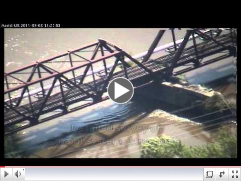 | | Rail Line Surveying by ASSIST-U.S. |
|
|
Conclusion
|
The rail road industry's use of state-of-the-art ADA procedures can save it valuable time and labor costs by:
- Improving the efficiency of track surveys
- Providing an alternative visual perspective during safety inspections, and
- Adding an additional layer of security to its infrastructure protection program.
ASSIST-U.S.® stands ready to perform this function throughout the northeastern U.S. and eastern Canada.
To request a demonstration of our ADA services or for more information about how our services can help your organization achieve its mission with customized aerial data and analysis, please use the directory provided here or on our website to contact a company representative.
|
|
Thank you for reading this month's newsletter. If you know others in your organization or community who would be interested in what we're doing, please use the "Forward email" link at the bottom of this page.
For a directory of our team, visit our website here. Visit our YouTube channel, LinkedIn group and Facebook page to see other examples of what we do and how we can support your needs for enhanced visual information through our aerial imagery services. Our member blogs contain articles of interest, as well. My most recent blog links to our "2011 in Review" newsletter, in case you missed it in January's edition.
 
 
For additional information on our customized missions, aerial acquisition and analysis services, visit our website. You can download our company capabilities brief here.
To schedule a pilot demonstration of any of our standard aerial data acquisition services, please contact:
- Rick Bartle, Director of Aviation Operations: 603-219-0922, X104, or
- Bruce Seibert, Product manager: 603-219-0922, X106
Sincerely,
Carolyn Abbott, Director of Marketing Communications
ASSIST-U.S.®
|
|
|
|
|
Copyright © 2012 by Aerial Surveillance, Security & Intelligence Systems Technologies-U.S., LLC. All rights reserved. ASSIST-U.S. is the registered trademark of Aerial Surveillance, Security & Intelligence Systems Technologies-U.S., LLC.
|
|
|
|

