|

| |
Hurricane Irene's Storm Path, August 27th, 2011
|
Preparing for Hurricane Irene's impact along the East Coast
ASSIST-U.S.® has positioned an aircraft at the Raleigh/Durham International Airport, 50 minutes from Cape Hatteras, to provide aerial surveillance in support
of emergency response teams in the aftermath of this devastating storm. The aircraft is staged west of this morning's landfall so that we can be on scene as soon as the storm has passed and it is safe to fly. We are presently available to help your disaster response and recovery teams with on-scene damage assessment, providing full motion video, in real time, to responders in the field. As the storm moves north, our flight team will follow the path of the damage and be ready to supply imagery to utillities, the insurance industry, corporations, and government agencies.
We know that when you deploy these teams in a storm's aftermath, performing post-storm damage assessment and triage are among the most difficult, dangerous and labor-intensive aspects of dealing with storms of this magnitude. Aerial imagery can help to ensure the safety of your personnel. This video, "Natural Disaster Response," provides an example of what our services can offer you, showing before and after views of the recent Springfield, MA, tornado damage area and the Vermont spring floods. 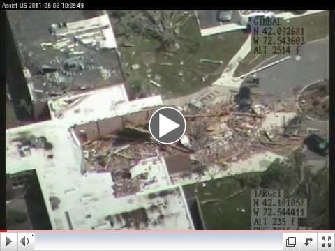 | | ASSIST-U.S. Natural Disaster Response |
View other examples of our post-storm damage assessment footage on our YouTube Channel (see link below) and our website, www-assist-us.com. |


