GISCorps logo 

GISCorps Newsletter


GIS Professionals Volunteering for a Better World


May 2011
A Message from the Core Committee


Greetings Volunteers and Friends,


Welcome to our new and improved GISCorps newsletter! We hope you like it! 


GISCorps has had an extremely busy spring. Since our February newsletter, 17 volunteers have been deployed to six new missions, four other missions have been concluded, and 52 volunteers are working on 13 other ongoing missions. That brings the total of deployed volunteers to 228 and the number of missions to 75!


Several of our missions were related to disasters:


  • Japan Earthquake: in partnership with USGS/JAXA and CrisisCommons
  • Post tornado assistance in St Louis County and Alabama: in partnership with St Louis EOC and CrisisCommons (at the request of Alabama EOC/Red Cross)
  • Assisting the Red Cross in Brisbane, Australia
  • Assisting the Central Oklahoma Red Cross

A number of non-disaster response missions are in progress including a new mission in Panama in partnership with Azuero, data mining/cleansing in the Caribbean with MapAction, watershed delineation in Malawi, and a GIS needs assessment project in Mozambique (for Niassa National Reserve).


Once again, our volunteers have proven that they rush to serve when they're called upon. It's a privilege and pleasure to work with such a dedicated group of individuals and we are truly grateful for that. We look forward to furthering our services to the underserved communities and those in urgent need of our volunteers' expertise.


GISCorps Core Committee,


Allen Ibaugh, Heather Milton, Dianne Haley, Shoreh Elhami, Mark Salling, Cindy Braddock

Deployment and Partnership News

Missions in Progress

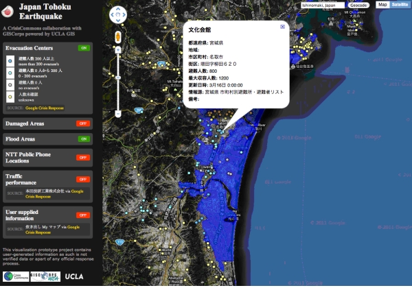
GISCorps volunteers assist in three disaster response missions in the US: Eight of our volunteers have been deployed to St Louis, Oklahoma and Alabama to assist in various post disaster tasks. These projects are in collaboration with CrisisCommons, Central Oklahoma Red Cross, and St. Louis County EOC. To learn more about each of these missions, click here.


Two volunteers are deployed to a project in Panama: Azuero Earth Project, a US based non profit organization requested the assistance of two GIS Specialists in developing a comprehensive hydrology dataset. Two GIS Specialists: Josh Garver of Franklin County Soil and Water Conservation District (SWCD) in Ohio, and Emily Cheadle of the town of Babylon Department of Planning and Development in New York were selected for this mission and will be working on this project for the next three months.


Seven GISCorps Volunteers recruited for a project with MapAction - Caribbean: Seven GISCorps volunteers have been deployed to a remote mission in the Caribbean. The request for volunteers was made by MapAction; a UK based nonprofit volunteer organization. The volunteers are currently involved in data mining, cleansing and standardization of several GIS datasets related to Saint Lucia, Belize, and Bermuda. They work directly with the MapAction teams in the UK and Caribbean. The GISCorps volunteers involved in this phase are: Anneka Imkamp, California, Kyung Kim, Virginia, Kevin Mayall, Bermuda, Tia Morita, California, Keith Olson, Colorado, Nathan Pugh, Utah, Jacob Spuck, Florida.      

A second volunteer is recruited for GRDC project - Nigeria: We recruited a second volunteer for Geographical Resources for Development Centre (GRDC), a non profit organization in Nigeria earlier in the year. Hassan Adekoya, a GIS professional from New York is now working with Alison Fischer, the first GISCorps volunteer who worked on this project, as well as with GRDC team. Hassan is adding more functionality to the website and will also train the GRDC team. To learn about the first phase, click here.

GISCorps volunteer is recruited for a project in Montgomery County, MD: GISCorps has recruited Robert George, a GISCorps volunteer from Pennsylvania, for a project in Montgomery County, MD. This project is in partnership with Identity, Inc, a US based nonprofit organization. Rob will assist Identity Inc. team with analyzing and mapping a variety of demographic and financial data of both upper and lower income school communities in Montgomery County.      

A second volunteer is recruited for NHS/UNO-PLUS mission - New Orleans: A second volunteer has been recruited for the University of New Orleans - Department of Planning & Urban Studies (UNO-PLUS) and Neighborhood Housing Services (NHS) mission. Smitha Peethambaram, a GIS Analyst with Mactec E & C in California, will be assisting UNO-PLUS/NHS in further enhancing the WhoData.org, an online application that GISCorps' first volunteer, Rafael Ferraro developed about a year ago. To learn about the first phase, click here.     

Conducting GIS Needs Assessment and Training - Mozambique: The Niassa National Reserve, a non profit organization located in northern Mozambique requested assistance in two areas: 1) conducting a GIS Needs Assessment of their existing GIS (remotely), and 2) training their local staff on the use of ArcGIS software for 3 weeks. The recruitment resulted in selecting Marci Meixler, a visiting professor at Rutgers University and two of her students: Carly Aulicky and Mike Tanis. Read more here.

Assisting a Micro loan Organization - Haiti: Fonkoze, a US based non profit organization, requested the assistance of a GISCorps volunteer in implementing a complete GPS data collection and web mapping of all of their "credit centers"; the 2000 locations that their clients meet at to repay loans, receive health and education services. Following a search, Joe Dickinson, a GISCorps volunteer from Seattle, WA was recruited for this project and is currently working with Fonkoze representatives. Read more here.


GISCorps Watershed Specialist recruited for a project - Malawi: Christiana Pollack, a GIS specialist with Princeton Hydro in New Jersey was recruited for a project in Malawi. The project is commissioned by WALA, a five year livelihoods program beginning in 2009 to improve food security for chronically food insecure households in Malawi, Africa. Christiana's initial attempt for delineating the boundaries of the first watershed has required further field work which is forthcoming.


Mission with Ministry of Tourism- Mozambique: The Ministry of Tourism requested the assistance of a remote sensing specialist. Kerry Brooks, a professor at Washington State University has conducted change detection on a section of the region and is now working on securing higher quality images for the remainder of the region.


Mission with iMMAP/WFP  - North Korea: The third round of recruitment and the project in general is going very well and more map sheets are digitized by the volunteers. The original request for volunteers came from the World Food Program (WFP) and Information Management and Mining Action Program (iMMAP). Volunteers are charged with the task of digitizing 400 map sheets and will create several data layers such as: settlement points, transportation (roads, foot path, and railroads), rivers and lakes. To see the latest status map and read more about this project, click here.


Mission with South Luangwa Conservation Society- Zambia: GISCorps volunteer, Lisa Matthies, a GIS and Geography Instructor at Erie Community College in Williamsville, NY has been supporting SLCS' GIS needs since spring of 2009. Read more about her ongoing support in here.     


Global Spatial Data Infrastructure (GSDI) Small Grants Program's 2010-2011 Projects: The 2010/2011 project resulted in providing a second volunteer to the Geographical Resources for Development Centre (GRDC); a Nigerian based non profit organization. More detail is listed under GRDC project description. Read about previous GSDI projects here.

Featured Projects


Earthquake/Tsunami relief mission with Crisis Commons - Japan: From March 12 to March 15, 2011, seven GISCorps volunteers were recruited to assist in mining various datasets in earthquake stricken areas of Japan. This mission was in collaboration with CrisisCommons. Volunteers worked on a variety of tasks for over one week. Volunteers came from: Australia, Canada, Switzerland, and USA. Read more here.

crisis
A screenshot of Japan Tohoku Earthquake application (on UCLA's server)

Remote Sensing Specialist assisted with a project in Japan: GISCorps was contacted by the U. S. Geological Survey (USGS) shortly after a massive earthquake hit the northeast region of Japan. The request was on behalf of a fellow member of the International Charter Space and Major Disasters (Charter), the Japanese Aerospace Exploration Agency (JAXA). They requested experienced remote sensing specialists who could quickly access, process, and publish high resolution imageries from various resources (all disseminated by the Charter).  The goal of the project was to analyze satellite imagery to help guide the emergency response efforts for the coastal communities that were either directly impacted by the tsunami inundation or, at the time, had not reported their condition. A call for qualified volunteers was sent out and in less than 24 hours, Terry Winemiller, an associate professor from Auburn University at Montgomery, Alabama and his team of students were recruited for the project. Read more here.

japan
A map of high resolution imagery in Miyako-shi region of Japan (created by Terry Winemiller)

GISCorps volunteer assisted in geo-locating child-mother clinics in Chiapas -Mexico: In late 2010, Juan Del Toro, a GIS professional with Instituto de Informaci�n Territorial del Estado de Jalisco, was selected for a project in Chiapas, Mexico. The project was brought to us by Maternova, a US based organization who is implementing a web-based portal focused on empowering frontline health workers and saving lives around the time of childbirth. Juan assisted Maternova in geo locating hospitals and clinics in the region. Read more here.

clinics
A map of geo-coded clinics in Chiapas, Mexico

Three GISCorps volunteers finalized a pilot project for the Red Cross in Brisbane - Australia: The Australian Red Cross - Emergency Services (QLD), based in Brisbane requested the assistance of GIS volunteers with experience in disaster response. The aim of the project is to have mapping tools that would improve the ability of the Red Cross team to document resource capacity and market this capacity to partner agencies. The recruitment resulted in selection of two volunteers in Brisbane (and vicinity) and one volunteer in the US. The volunteers were: Ori Gudes and Daniel Coogan from Australia and Scott Madry from North Carolina. The pilot project was completed in early 2011. Read more here.

brisbane
A flood extent model map of Brisbane CBD (created by MAPS)

Read more about completed projects here.

Read more about projects in progress in here.

Upcoming GISCorps Events 

Esri's 31st User Conference, San Diego, July 11-15, 2011

  • As in the past several years, GISCorps will be present at ESRI's 31st User Conference (San Diego, July 11-15, 2011) and be involved in a number of activities there.
  • Map Gallery - Please join us on Monday July 11th during Map Gallery hours from 4:30 to 8:30 pm to meet GISCorps volunteers and the Core committee members.
  • Annual meeting/presentation - The meeting will be held on Wednesday July 13th from 5:30 to 7:00 pm in room 5A/B. The Core Committee members and several of our volunteers will give presentations on 2010/2011 activities. Following the presentation, there will be a no-host gathering at a nearby restaurant. The location will be posted on GISCorps' website as well as on FaceBook, Linkedin and Twitter.


49th URISA Annual Conference (GIS-Pro 2011)

Indianapolis, IN, November 1-4, 2011


Since 2003, GISCorps has been holding several events at the URISA International Conference. We hope that you can join us in Indianapolis (from November 1-4, 2011). This year's events are:   


  • Annual Presentation - Thursday November 3rd, from 9 to 10 AM - several volunteers and GISCorps Core Committee members will give an overview on 2010-2011 projects and activities.
  • Annual Meeting - the annual meeting will be held during the conference.
  • Poster Exhibit - throughout the conference the work of our volunteers will be on display.


Note: If you are a deployed GISCorps volunteer and plan to attend this Conference, please let us know by sending an email to: [email protected].

News from Friends of GISCorps

Thank you for your continued support of URISA's GISCorps!

In This Issue
Message from the Core Committee
Missions in Progress
Featured Projects
Upcoming Events
Friends of GISCorps News

URISA News

URISA Leadership Academy - register today!  


GIS in Public Health Conference - register today!


$20 Membership - join today!


URISA Chapters  


More About Us 

Get Social with GISCorps! 

Find us on Facebook 

View our profile on LinkedIn 


Follow us on Twitter 


Shop for

GISCorps Stuff

Do you find yourself in need of a new T-shirt, coffee mug, ball cap or tote bag? Do you want to advertise GISCorps and your association with the organization? Well, you are in luck! You can now find various GISCorps items at our online shop at: http://www.cafepress.com/giscorps  


Partner Organizations

GSDI   

UNOSAT  

UNDP   

UNHCR  

CrisisCommons  

iMMAP  

WFP   

Disaster Charter   

MapAction 

...and many more

GISCorps Core Committee


Allen Ibaugh, Chair

Heather Milton, Vice Chair

Dianne Haley

Mark Salling

Cindy Braddock

Shoreh Elhami, Co-founder


Contact us:

www.giscorps.org 


Email: [email protected] 


Twitter: @giscorps


ula 

publichealthlogo


transit

gispro