 |
| Complete Streets: Bicycle & Pedestrian Independence | 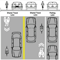 Independence- we celebrate this in July as a nation. The word has another meaning for non-drivers: the independence to walk, use a wheelchair or ride a bicycle and get where you need to go safely and conveniently. Independence- we celebrate this in July as a nation. The word has another meaning for non-drivers: the independence to walk, use a wheelchair or ride a bicycle and get where you need to go safely and conveniently.
Our feature story this issue highlights Tampa's Complete Streets efforts. Complete Streets are designed to be safe and convenient for travel by automobile, foot, bicycle and transit, regardless of age or ability. Complete Streets transform the way transportation serves people, by creating more choices.
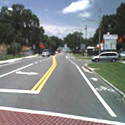
Tampa's recent Euclid Avenue, Palm Avenue and North Boulevard projects bring the city closer to "completing" its streets. In a time of declining government budgets, Tampa is doing more with less by making the most of its repaving program. When a street is being resurfaced and repainted, bike lanes/markings and wheelchair-access points can sometimes be added at little additional expense.
New traffic engineering innovations also play a role. Shared lane arrows, sometimes called sharrows, are now a nationally-recognized pavement marking, and Tampa brought them to our county for the first time on the Euclid Avenue resurfacing. Euclid makes an important connection between South Tampa neighborhoods and the Bayshore Boulevard corridor. Shared lane arrows draw attention to the presence of cyclists on the road, which is too narrow for both bike lanes and on-street parking.
Jean Dorzback, Tampa's Transportation Manager, says, "With creativity, we can combine a resurfacing project, a sidewalk project and the good will of the traffic engineers to create a new kind of road improvement that enhances travel in many ways."
Providing for diverse users does require some out-of-the-box thinking. With that in mind, the MPO recently assisted the City of Tampa in preparing the first phase of a Walk Bike Plan. The plan identifies low-cost improvements to help cyclists, cars, and pedestrians safely share the road, connecting the city's business centers with adjacent neighborhoods and other destinations. Future phases of study will look at more areas of the city.
For more information on the Walk Bike Plan visit: http://www.hillsboroughmpo.org/pubmaps/pubmaps_folders/draft-publications/walk-bike-implementation-plan-for-city-of-tampa/TampaMobilityPlan_PhaseITechMemo_MainDoc.pdf or contact Michele Ogilvie at ogilviem@plancom.org, 813-273-3774 ext. 317
.
|
|

|
"Dangerous By Design" Cites National and Local Pedestrian Deaths
|  The decades-long neglect of pedestrian safety in the design and use of American streets is exacting a heavy toll on our lives, according to a recently released national report published by Transportation for America. From 2000 to 2009, 47,700 pedestrians were killed in the United States, the equivalent of a jumbo jet full of passengers crashing roughly every month. Despite the magnitude of these avoidable tragedies, little public attention - and inadequate public resources - have been committed to reducing pedestrian deaths and injuries in the United States, says the report. The decades-long neglect of pedestrian safety in the design and use of American streets is exacting a heavy toll on our lives, according to a recently released national report published by Transportation for America. From 2000 to 2009, 47,700 pedestrians were killed in the United States, the equivalent of a jumbo jet full of passengers crashing roughly every month. Despite the magnitude of these avoidable tragedies, little public attention - and inadequate public resources - have been committed to reducing pedestrian deaths and injuries in the United States, says the report.
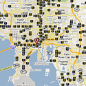
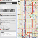
An interactive map available at http://t4america.org/resources/dangerousbydesign2011/map/ makes the case that arterial roads are by far the most dangerous for anyone afoot or on a bike. The map's quick lesson for the Tampa area is that the roads themselves seem to be a major part of the problem. Clusters of crashes are found on Dale Mabry Highway, Kennedy Boulevard, Lumsden Road and U.S. Highway 41, multi-lane, high speed roads with shops and destinations on both sides and many nearby neighborhoods. On the bright side, fewer crashes are shown on Bruce B. Downs Blvd or the Brandon Parkway, where walking and bicycling is encouraged on a separate trail. For more info visit T4 America at http://t4america.org/.
|
|

|
Bicycle & Pedestrian Safety: Next Steps
| 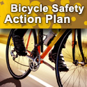 Demonstrating that Hillsborough's Pedestrian and Bicycle Safety Action Plans won't just sit on a shelf, FDOT District 7 convened a Safety Summit on June 8, and made several announcements. Demonstrating that Hillsborough's Pedestrian and Bicycle Safety Action Plans won't just sit on a shelf, FDOT District 7 convened a Safety Summit on June 8, and made several announcements.
- FDOT plans to provide bike lane signs/ pavement markings and wrong-way riding safety warning signs on over 100 miles of state highways in this region.
- The District will also make at least $1 million available to local governments in fiscal year 2012 for ped-bike safety projects on city and county roads.
- District 7 will continue its public outreach and education efforts in fiscal year 2012, complementing the popular "Walk Wise" campaign with "Bike Smart."
Meanwhile, the MPO in May committed some of its 2012 planning funds to ped-bike safety public education and road audits.
The Hillsborough Countywide Pedestrian Safety Action Plan (PSAP) and Bicycle Safety Action Plan were developed to help local government agencies focus on the pedestrian and bicycle crash issues specific to their jurisdiction, provide a set of proven engineering, enforcement, education, and emergency medical services (4E) strategies for consideration, and help practitioners understand the tools and organizational changes necessary to implement these
strategies.
For more information, contact Peter Hsu at Ping.hsu@dot.state.fl.us, 813-975-6257, or Gena Torres at torresg@plancom.org, 813-273-3774 x. 357.
|
|
|
Bike Lanes & More on Bayshore
|
 | | Credit: Jim Reed/TBO staff |
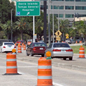
Bayshore Boulevard, Tampa's signature roadway, is undergoing a $1.48 million transformation this summer. The first phase of the three phase project will provide continuous 4-foot-wide bicycle lanes in both directions along the north-south waterfront roadway, from Rome Avenue to Platt Street, about 1.4 miles. The stretch from the Davis Island Bridge to Rome Avenue will be modified from six to four lanes to accommodate not only the bicycle lanes, but a 14-foot-wide landscaped median. Modification of the shorter, four-lane stretch between Platt Street and the Davis Island Bridge will include the bike lanes and a concrete median.
In addition to providing bicyclists with a designated, marked area of the roadway, the project provides other safety enhancements. Those include upgrading existing traffic signals and pedestrian/cyclist safety features at the Bayshore crosswalks at Bay to Bay Boulevard and Platt Street. Additionally, left-turn bays will be created in the northbound lanes at several intersections where turns now are legal.
The project is funded by the City of Tampa with the assistance of a federal grant prioritized by the MPO. Future phases are planned for other segments of Bayshore.
|
|
|
Nebraska Ave Success Story
|  The results are in on a lane diet project along Nebraska Avenue (US 41) in Central Tampa. The results are in on a lane diet project along Nebraska Avenue (US 41) in Central Tampa.
The diet converted the 4-lane undivided roadway with 2 travel lanes in each direction to a 2-lane road with medians and left turn lanes. Bike lanes and bus pull-off bays are provided throughout the corridor.
A before-and-after crash analysis by FDOT found that overall crash frequency and crash rates as well as crash severity along the corridor have decreased since the lane diet.
Prior to retrofitting Nebraska Ave exhibited a crash rate 50% higher than the average crash rate for urban 4-lane undivided roadways. After retrofitting, pedestrian crashes have been reduced from 7 to 2.5 per year, average bicycle crashes have been reduced from 5.0 to 1.7 per year . Overall there has been a 61% reduction in fatal/incapacitating crashes per year.
For more information on the crash study contact Ron Chin at FDOT District 7 at 813-975-6000.
|
|
|
Tampa's Independence From Oil Day
|  A year after the BP oil disaster in the Gulf of Mexico, and following a spring of near record high gasoline prices that put a huge strain on many people's budgets, Tampa's new mayor, Bob Buckhorn, has proclaimed this 4th of July "Independence From Oil Day." In his proclamation, the mayor affirms that "the City of Tampa agrees that cycling and walking are viable transportation alternatives and promotes them as key components of our sustainable transportation efforts while reducing the reliance on oil." Citing "recent oil spill disasters," he goes on to state that "it is important for alternate modes of transportation be explored and utilized, and bicycle and foot travel do not rely on fossil fuels and are non-polluting means of travel." In closing, Mayor Buckhorn encourages "all residents to try bicycling and walking as a form of transportation that protects the environment." By following the Mayor's advice, Tampa residents could not only help the environment, but also save substantial amounts of money, improve their health and physical fitness, reduce traffic congestion, and help reduce the country's use of oil. A year after the BP oil disaster in the Gulf of Mexico, and following a spring of near record high gasoline prices that put a huge strain on many people's budgets, Tampa's new mayor, Bob Buckhorn, has proclaimed this 4th of July "Independence From Oil Day." In his proclamation, the mayor affirms that "the City of Tampa agrees that cycling and walking are viable transportation alternatives and promotes them as key components of our sustainable transportation efforts while reducing the reliance on oil." Citing "recent oil spill disasters," he goes on to state that "it is important for alternate modes of transportation be explored and utilized, and bicycle and foot travel do not rely on fossil fuels and are non-polluting means of travel." In closing, Mayor Buckhorn encourages "all residents to try bicycling and walking as a form of transportation that protects the environment." By following the Mayor's advice, Tampa residents could not only help the environment, but also save substantial amounts of money, improve their health and physical fitness, reduce traffic congestion, and help reduce the country's use of oil.
View Mayor Buckhorn's Independence From Oil Day Proclamation here: http://www.tampagov.net/proclamations/20110704_Independence_From_Oil_Day.pdf
|
|
|
How Should I Know Where To Walk?
|  The Center for Urban Transportation Research (CUTR) at USF has created a multimodal trip planner using open source tools as part of a research project to explore the current state-of-the-art in multimodal trip planning, allowing you to plan trips by foot, bicycle, bus and other forms of transit. CUTR advises that its project is not intended as a travel resource, but as a tool to showcase the strengths and weaknesses of such as system using data from the Tampa area. The Center for Urban Transportation Research (CUTR) at USF has created a multimodal trip planner using open source tools as part of a research project to explore the current state-of-the-art in multimodal trip planning, allowing you to plan trips by foot, bicycle, bus and other forms of transit. CUTR advises that its project is not intended as a travel resource, but as a tool to showcase the strengths and weaknesses of such as system using data from the Tampa area.
The project report, Enabling Cost-Effective Multimodal Trip Planners through Open Transit Data, can be viewed here: http://www.nctr.usf.edu/2011/05/enabling-cost-effective-multimodal-trip-planners-through-open-transit-data-2/
The multimodal trip planner can be viewed here: http://opentripplanner.usf.edu/ |
|
|
| Highway System for Cyclists To Be Expanded |  U.S. Secretary of Transportation Ray LaHood recently noted on his blog that the Association of American State Highway and Transportation Officials has approved the first new routes in the national bike system in more than 30 years. U.S. Secretary of Transportation Ray LaHood recently noted on his blog that the Association of American State Highway and Transportation Officials has approved the first new routes in the national bike system in more than 30 years.
The six new routes are in Maine, New Hampshire, Michigan, and Alaska. The AASHTO has also released a map showing "prioritized corridors," to be developed as other states get on board. The idea is to eventually have a comprehensive network of routes crisscrossing America.
More information on the US Bicycle Route System: http://www.adventurecycling.org/routes/nbrn/usbrsFAQ.cfm
|
|
|
|
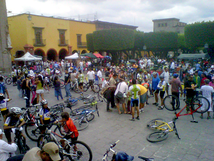
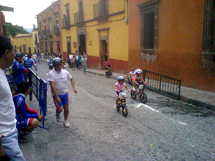
The Challenge of the Criterium
| |
 The Criterium, or crit, is a bike race held on a short course and often run on closed-off city streets. Downtown Tampa was host to the well-attended Cigar City Brewing Criterium and Festival in March of this year. The Criterium, or crit, is a bike race held on a short course and often run on closed-off city streets. Downtown Tampa was host to the well-attended Cigar City Brewing Criterium and Festival in March of this year.
BPAC Chairman Jim Shirk recently competed in a crit race in San Migeul de Allende, Mexico and shares his thoughts and photos from the event:
"How can you tell the town is hilly and the streets are rough? The criterium bicycle races in which we in Tampa compete on road bikes is run on mountain bikes in San Migeul de Allende, a regional center of art and culture in the central highlands of Mexico known as the Bajio. City streets follow the plans established in the 17th Century, when the region was the heart of Mexican silver mining, rising on up to 15 percent grades and paved with pumpkin sized stones. Still, the races were well attended with an international group of riders, some from the United States, and ranging in age from toddlers in a special short course to their elders on the longer circuit around the city streets. The art work was very scenic as seen in the photos with impressive organization , and the riders showed real strength competing at the 6,000 foot elevation that keeps lowlanders panting. Also, the booths would have really been fun transplanted to the 2012 Tampa Criterium races next March. Oh well, we can dream of Mexican street food and bicycle parts sales next year."
|
|
|
|
|
|
Upcoming Meetings
BPAC : 5:30 pm, 7/13/11
LRC : 9:00 am, 7/27/11
Planning Commission Boardroom, 601 E Kennedy Blvd, 18th Floor, Tampa
|
|
|

