| Published by: | 
|
|
| Greetings!
The Fall 2010 issue of Runoff Rundown is here!
The Center has been busy this fall. The articles in this issue provide a peek at some of what we have been working on. In other news, the inaugural issue of the Watershed Science Bulletin has been released! The Fall 2010 issue theme is TMDLs: Innovations and Implementation. We are already hard at work on the Spring 2011 issue focused on Climate Change and Watersheds. If you haven't signed up already, go to www.awsps.org to join the Association of Watershed and Stormwater Professionals and receive the Bulletin plus other member benefits. Lastly, we have two more webcasts planned for 2010. See the Training and Conferences section below for more information.
|
| Runoff Ramblings
Water Supply, Wastewater & Stormwater: Are These Cousins Kissing or Feuding?
by David Hirschman, with contributions from Bill Stack
The following sad story was recounted recently by a kid on the playground: "I am frustrated. My name is Stormwater. I have two cousins, Water Supply and Wastewater, and they don't play with me anymore. We have the same grandparents (named Rain and Snow), but Water Supply and Wastewater are older and more sophisticated. I just want them to play with me." I feel Stormwater's pain. Earlier in my career, I held a joint position between a water and wastewater utility and a county government. The position focused on watershed management for a drinking water reservoir, recognizing that the quality of the product (clean drinking water) had as much to do with the watershed as it did with the treatment process. The program integrated the utility's concern with water supply management with the county's responsibilities for land use planning, stormwater management, and development review. The key word here is integration. These days, we are quick to evoke terms such as sustainability and integrated resource management, but it seems harder to actually accomplish the integration needed to achieve those lofty goals. We can't even agree on spelling conventions, such as whether the "water" part of the terms "surface water," "groundwater," "stormwater," and "wastewater" should be its own word. Why? Certainly, part of the issue has to do with the regulatory context that puts water supply, wastewater, and stormwater into their respective programmatic silos. The structure of local government can be another issue, with drinking water and wastewater generally handled by utilities and stormwater being housed in an engineering or planning department (not withstanding a new generation of integrated utilities discussed below).  Figure 1. The Regulatory & Programmatic Silos for Water Management Figure 1. The Regulatory & Programmatic Silos for Water Management
As my friend and former CWP colleague, Mike Novotney, points out, we tend to use different metrics to evaluate and manage the three systems, as described in Table 1. These metrics are regulation and project-centric, and are not always relevant at the watershed or community scale. Mike proposes a "water portfolio" concept to integrate water sources and needs at a watershed scale (see Novotney, 2010). Table 1. Metrics for Gauging "Success" for the Three Water Management Sectors
Water Supply
· Meet safe yield demand
· Meet Safe Drinking Water Act standards
· Meet minimum instream flow requirement below reservoirs
Wastewater
· Provide treatment capacity
· Comply with NPDES discharge permit
Stormwater
· Match post-development to pre-development discharge
· Treat the water quality volume
· Comply with MS4 permit
Granted, each of the three regulatory and programmatic systems has accomplished tremendous things over the course of several decades. But, the question must also be asked, what types of integration, efficiency, and creative management have been thwarted by the silo approach? Perhaps more importantly, are we meeting human needs and protecting and preserving ecosystem services in the best way possible? What would be possible if the metrics for achieving success were integrated across the three sectors, and also integrated at the watershed scale?
Much has been written about "Integrated Water Resources Management" and "Total Water Management" (a slightly different topic), and my intention is not to review all of the theory and practice behind these topics. Many organizations, such as the American Water Works Association and the Water Environment Federation, not to mention many academics, have written on the topic.
Suffice it to say, there are some promising trends that portend enhanced levels of integration. Among them:
Combined sewer systems (CSOs) across the country are starting to look at green infrastructure approaches for keeping more stormwater out of the combined system. The common denominator for these efforts is volume, with efforts focusing on using the landscape and other BMPs to achieve a more natural "separation." For examples, see Philadelphia, Cleveland Metro Sewer District, Cincinnati, Portland, Minneapolis, and many others (sorry if I left yours out). Many municipalities are adopting stormwater utilities and housing these within their existing water and wastewater utility departments. In some cases, the water and wastewater managers are looking at stormwater as a new and exciting challenge; others see it as a gawky and obnoxious teenager that has come to spend the summer. In either case, as time goes by, these unified utilities will achieve heretofore unrealized levels of integration on financial and resource management levels. A growing number of development projects are exploring rainwater harvesting, not just as a source of water for irrigation, vehicle washing, or toilet flushing, but as a way to manage stormwater runoff. Increasingly, new stormwater ordinances and design manuals are incorporating particular standards for rainwater harvesting (for an example, see the Virginia Stormwater BMP Clearinghouse). More formalized integration exists in some states, such as Maryland, which, in 2006, adopted state legislation known as the "Water Resources Element." This legislation requires that local jurisdictions modify their comprehensive plans to assure that existing and future development can be supported by water and wastewater resources and to provide goals, policies and strategies for conservation, pollution reduction, and prevention of water quality degradation. Essentially, the plans have to address whether there is enough water and wastewater capacity to support future growth and how much development the watershed(s) can accommodate before nutrient load thresholds (e.g., TMDLs) are exceeded. For more information, see the Maryland Department of Planning's publication The Water Resources Element (document #26 under Models and Guidelines). Some localities, such as Cary, N.C., have developed locally-driven integrated water resources management plans (Novotney, 2010; see the Integrated Water Resources Management Plan on the Town of Cary's website).
There are other drivers for water resources integration. Planning for climate change is fueling a new vigor for looking more holistically at water, infrastructure, ecosystem services, and public safety. These are not just academic concerns. Water is limited, and our communities live within the constraints and opportunities of the hydrologic cycle. Let's start planning and managing the system as if that really matters. The playground is large enough for all the water cousins to play nicely together (whether they actually do is not my concern).
Let us know your thoughts and ideas on this topic. Email us at rambler@cwp.org. If you'd like to contact Mike Novotney, he can be reached at Baxter & Woodman, Inc., (312) 578-0050, mnovotney@baxterwoodman.com.
References
Novotney, Michael E., P.E. Watershed-Based Planning to Integrate Water Resource, Stormwater and Wastewater Management Efforts (PowerPoint presentation). IWEA 2010 Annual Conference. Peoria, IL. March 2010.
|
| |
|
Center Sewage Sleuths Help to Reduce Pollution in Baltimore Streams
 Illicit Discharge Detection and Elimination (IDDE) is a requirement of MS4 permits; however, it can also be an efficient and cost effective best management practice (BMP) that communities with non-stormwater discharge (NSD) problems can utilize to meet water quality goals and TMDLs. In addition, it has the potential to be used as tool within the framework of an integrated water management strategy for wastewater, drinking water and stormwater. The benefits of an effective IDDE program to local jurisdictions stretch beyond the MS4 permit and into the realm of total watershed management. The implementation of IDDE field surveys can help to isolate problems at the subwatershed and reach level and, eventually, to the source of significant pollution problems. The Center for Watershed Protection (the Center) conducted illicit discharge outfall screening in two subwatersheds in Baltimore, Western Run and Moores Run, as well as a portion of the Jones Falls mainstem with the following goals: - Inventory and collect data from all dry weather flowing outfalls
- Work with City to eliminate NSDs
- Calculate NSD loadings from nitrogen, phosphorus, bacteria and pollutant volume
- Document findings in a technical memo
- Communicate project results
The Center, Baltimore City, Baltimore County and watershed group staff, with the help of volunteers, walked over 18 miles of stream in May - July 2010 to assess 81 outfalls within the study area. Field crews determined the illicit discharge potential of individual outfalls from physical indicators and an ammonia test and then took three grab samples that were analyzed for additional parameters including total nitrogen, total phosphorus, fluoride, anionic surfactants (detergents), potassium, E. coli and total coliforms. This suite of parameters can help to determine a source of pollution as either wastewater, washwater, tap or irrigation water, or groundwater.
Results of the study point to a significant amount of pollution from NSDs in these watersheds. 80% of all outfalls surveyed for dry weather flow exceeded one or more thresholds for the parameters identified above. Sewage contamination from accidental cross-connections, sewer line failures, choked sanitary stacks and so on contribute a significant amount of nutrient and bacteria load to receiving water bodies. The nutrient load from confirmed sewage discharges found in one subwatershed of this study represent 50% of total in-stream nitrogen load, 8% of the total in-stream phosphorus load and only 1% of the total stream discharge. In addition, it was determined that up to 550 million gallons of treated drinking water is lost through leakage in just 11 outfalls surveyed on the Jones Falls mainstem. Approximately 50% of all outfalls with dry weather flow exceeded the EPA water quality standard for water contact recreation (235 CFU/100 ml).
Source tracking efforts by City and County staff led to the elimination of some of the problems that were found, including several of the major sewage sources, and the remaining are being addressed or on schedule to be re-tested. If left untreated, the illicit discharges detected through this study could contribute 12,500-37,500 lb/year of total nitrogen and 500-1500 lb/yr of total phosphorus (a range of 50-150% is reported as these discharge are often of a diurnal or intermittent nature). The elimination of these pollution sources by tracking them down and fixing them has resulted in a reduction of 7,300-22,000 lb/year of total nitrogen and 400-1200 lb/yr of total phosphorus. The average E. coli count for the fixed problems was well above safe levels, with an average >45,000 CFU/100 ml detected. In addition, a major water main break was found and is scheduled for repair. The break represents a loss of over 300 MG/yr of treated drinking water as well as a significant nitrogen load.
Overall findings of the project include the following:
- Illicit discharge surveys can help communities to determine the impact to receiving water quality by NSDs during baseflow conditions
- IDDE can be used as a best management practice to meet nutrient and bacteria water quality standards as well as TMDLs.
- The MS4 and Sanitary Sewer program must collaborate on the prevention and efficient/effective fix of illicit discharge problems.
- Minor outfalls, those less than 36" in diameter, contribute heavily to pollution and should be monitored alongside major outfalls.In this study, 45% of all flows exceeding the established criteria for dry weather flow came from small pipes and all small pipes exceeded one or more thresholds.
- Leakage of treated drinking water is significant; 11 outfalls on the Jones Falls mainstem represent a potential loss of up to 550 million gallons per year of treated drinking water.
- E. coli levels were pervasive throughout the study area, including in those outfalls determined to be "clean," that is, not exceeding any of the illicit discharge criteria.
- Watershed groups and municipalities can collaborate to implement an effective IDDE program and citizen water quality monitoring groups can enhance existing program by using some of these strategies.
- IDDE is one potential tool for integrated water management of drinking water, stormwater and wastewater.
For more information about this project, contact Lori Lilly. |
| |
The Eight Tools are Going Coastal!
Project Background
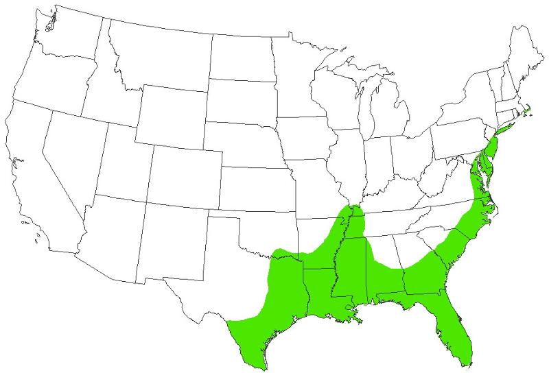
In 1998, the Center for Watershed Protection (the Center) created a comprehensive local framework for watershed planning known as the Eight Tools of Watershed Protection. The "Eight Tools" address land development stages from initial land zoning to site plan development and review through construction and occupancy. Since then, the Center has applied the "Eight Tools" in numerous watersheds across the country and has continuously tested, refined, and updated it. Although the "Eight Tools" framework has been used throughout the United States, many of its specific recommendations are derived from research in the Piedmont province, and it was unclear how well these recommendations would apply in regions with different physical characteristics and development patterns, such as the Atlantic coastal plain province. The Atlantic coastal plain borders the Atlantic Ocean and Gulf of Mexico from Cape Cod down to the Mexican border. It stretches 2,200 miles in length and includes portions of 21 states (see map below). To address this gap, the Center conducted a two-year research effort focused on developing improved watershed management tools for the coastal plain.
 Research Methods and Key FindingsMajor research tasks for this project included a watershed management needs survey of coastal plain communities and a review of literature on the impacts of urbanization on coastal plain water resources. Coastal Needs Survey The Coastal Needs Survey, distributed in the fall of 2008, was designed to understand how resources are currently managed in the coastal plain, and to quantify the needs of coastal plain watershed managers. Representatives from 73 coastal plain communities completed the survey. And while survey results revealed that the majority of communities implement the eight tools of watershed protection to some extent, the tools are somewhat limited by ineffective application or incomplete implementation. Although the communities have, for the most part, sufficient technological capacity, staffing limitations and political will hamper implementation of watershed protection practices. Although the coastal plain has certain unique physical characteristics, many of the key challenges identified by watershed managers, such as lack of funding and limited staff resources, are not unique to the coastal plain. The survey results suggest that communities put most of their resources towards satisfying regulatory mandates, leaving few, if any, resources to 'add' new initiatives, such as watershed planning. Greater consolidation or coordination between land use planning, watershed management, and stormwater management programs may help these communities realize efficiencies that allow them to pursue watershed protection, while simultaneously continuing to meet federal mandates. Literature ReviewIn order to clarify the relationship between land use factors and coastal watershed health and translate these findings into practical management tools for the coast, we reviewed forty-six research studies that evaluate the influence of land use change on the quality of aquatic resources in the coastal plain. Findings from these studies suggest that indicators that measure the intensity of development (e.g., impervious cover or total urban land) in the study watershed, or the location of developed land in relation to the sampling station (e.g., urban land within a specific distance from the stream corridor) are the best predictors of aquatic health. Several other non-urban indicators, such as septic system density, also showed some potential to predict aquatic health, but additional research is needed to draw firm conclusions. One of the original intents of the project was to develop a "coastal impervious cover model," which would relate watershed impervious cover in the coastal plain to aquatic health in these watersheds. Taken as a whole, the research did not point to a new model, and in fact suggest that the impacts of land development in the coastal plain are similar to those in the Piedmont. One significant difference, however, appears to be that the location of development may be more important in the coastal plain than in the Piedmont. The flat topography and extensive wetland network found in the coastal plain offer one explanation for this finding. While riparian buffers play an important role in the Piedmont, the relatively steep slopes of that region often create a conditions where stormwater runoff can "short circuit" the buffer, either by direct piping, or through concentrated flow conditions. In the coastal plain, on the other hand, the extensive flat areas and wetlands adjacent to streams and other waterways create a more effective buffering and filtering mechanism to mitigate the impact of development. Project ProductsUsing the combined results of the survey and literature review along with input from researchers and managers working in the region, we developed an adapted "Eight Tools" framework for the coastal plain. In many cases the results are applicable beyond the coastal plain to other coastal regions or to regions with similar characteristics and challenges. A special issue of the Center's publication Watershed Protection Techniques, focused on coastal plain watershed management, presents the "Coastal Eight Tools" framework. The introductory articles in this issue provide the context for coastal plain watershed management while the remaining articles discuss the "Coastal Eight Tools" and provide examples applications in coastal plain watersheds. The Coastal Plain Watershed Information Center, another product of this project, acts as a repository for the coastal plain information developed through this project and gleaned from others' relevant work. The site currently includes the special coastal issue of Watershed Protection Techniques, a selection of the "best of the best" coastal watershed resources, case studies, and outreach materials for coastal managers. We will continue to add to this site as we work on a related project to address barriers to implementation of low impact development in the coastal plain. For more information about his project, contact Karen Cappiella. Funding and support for this project was provided by CICEET, the Cooperative Institute for Coastal and Estuarine Environmental Technology. A partnership of the National Oceanic and Atmospheric Administration and the University of New Hampshire, CICEET develops tools for clean water and healthy coasts nationwide. |
| |
Center Releases New Watershed Curriculum Module
The Center is always looking for ways to learn about the latest research and technologies to advance the fields of watershed and stormwater management to protect and restore our watersheds. We recently had the opportunity to go to the source of learning and work with three universities to develop watershed-based curriculum into existing courses. Universities play a critical role in building watershed capacity by introducing students to the watershed profession, training them on the latest watershed methods, and conducting research to improve watershed understanding and practice. We surveyed universities throughout the United States to identify their watershed curriculum needs and initiate the development of the materials. We were pleased to find that watershed science, as well as stormwater management, is being taught in a diverse range of departments to include geography, biology, ecology, engineering, landscape architecture, as well as interdisciplinary natural science-political science programs. An EPA Targeted Watershed Grant provided funding to work with three university partners who were selected based on their interest identified in the survey and location in different regions throughout the United States. A secondary goal was to work with a program where the subject of watersheds was not typically a part of the traditional course curriculum but would advance the student's understanding of their field of study. Our appreciation is extended to our partners who were willing to work with us to develop these new materials and test them in their classes earlier this year. The partners were: Professors William Jones from Indiana University, School of Public and Environmental Affairs, Christina Cianfrani from Hampshire College, School of Natural Science and Ken Yocum from University of Washington, Department of Landscape Architecture. The materials developed as a result of this project are integrated into the Center's first Watershed Curriculum Module (WCM), available at www.awsps.org. The WCM offers three units that are designed to enhance a student's critical thinking skills by applying knowledge learned in the classroom to 'real world' examples, to define and test hypotheses, and integrate multiple sources of information to analyze data and make recommendations for future management decisions. Unit 1: Watershed Assessment
The Watershed Assessment unit provides instructional versions of three popular field assessments to identify pollutant sources in neighborhoods, commercial & institutional hotspots, and evaluate the condition of stream reaches. The material is adapted from the Center for Watershed Protection's eleven manual Urban Subwatershed Restoration Manual series. This unit provides an opportunity for students to develop field skills and translate their findings to solutions to better manage watersheds and stormwater. Also, check out the stormwater retrofit training videos on YouTube that were also developed as a part of this project. The videos are four and a half minutes to eight minutes in viewing time. There are three videos that introduce the concept of stormwater retrofits and how to conduct an assessment in the field. The retrofit videos can be accessed at the links below: Unit 2: Watersheds & Growth: Land Use Planning as a Best Management Practice The "Watersheds & Growth" unit is a creative, hands-on group exercise for students to explore the impacts of development on watershed health and how land use planning decisions about the location and density of development may reduce these impacts. Students use Lego© pieces that represent development to decide where to place growth on a watershed map. A supplemental photo gallery is provided to complement this unit to illustrate various site design practices and techniques known as "better site design" or "environmental site design" practices. These practices work together to reduce the amount of impervious cover, protect natural resources and provide effective stormwater management on development sites. Unit 3: Watershed Treatment Model An instructional version of the Center's updated Watershed Treatment Model is provided with an example case study and scenarios to familiarize students with an empirical model to evaluate the impact of urban development and identify treatment options to reach a targeted pollutant load and runoff reductions. A copy of the WTM, an instructional guide and a case study is provided for students to learn more about the WTM and how to use it. Members of AWSPs can download these materials as a benefit of membership at www.awsps.org. Contact Neely Law for more information or if you are interested the Center helping you with your watershed curriculum needs. |
| |
Trainings and Conferences
Center for Watershed Protection Webcast Series
Rooftop Disconnection, Filter Strips & Rainwater Harvesting October 20, 2010, 12-2 Eastern Cost: $99 early bird Innovative stormwater management starts at the rooftop and the yard, whether for residential, commercial, or institutional applications. This webcast will review various disconnection techniques: simple downspout disconnection, small scale infiltration and bioretention, compost-amended soils, and rainwater harvesting. Case studies will cover several interesting approaches for inspecting and maintaining these types of distributed practices. Better Site Design Gets Better December 15, 2010, 12-2 Eastern. Cost $99 early bird The Center for Watershed Protection first introduced the concept of Better Site Design (BSD) in 1998 and has used BSD in its work with many communities. The objective of BSD was and remains to improve local development codes so that development and redevelopment projects can reduce impervious cover and runoff. However, new concepts and innovations in development design and stormwater approaches have provided an opportunity to update BSD. Whether you are a seasoned Development Roundtable veteran, or new to BSD, this webcast will introduce you to a "better" way to do Better Site Design. Where We're Speaking
Featured Trainings and Conferences Riparian Workshop: Restoration & Management of Streams, Wetlands & Floodplains. October 12-13, 2010. TCU Dee J. Kelly Alumni Center, Fort Worth, Texas. The Restoration and Management of Riparian Corridors Workshop will bring together a host of participants in order to share ideas, research, case studies and best practices with a community of stakeholders that includes cities, agencies, scientists, regulators, consultants, developers and planners. This workshop will provide current information on guidelines and bioengineering applications for stream and wetland restoration. Special attention will be given to techniques available to address the effect of surface runoff on stream channels and riparian corridors in the urban environment. Speakers will focus on stream channel evolution, channel and bank design involving natural and synthetic material for stability and function, and ecological restoration in zones outside the main channel. NACO Webinar: How Can Smart Growth Put Your County On a Path to a Green Economy? Thursday, October 14, 2-3:15 PM Eastern Join the webinar to explore the innovative land use and design strategies available for promoting green economic development and develop comprehensive plans and building policies to create jobs and save money. 2010 American Water Resources Association Annual Water Resources Conference. November 1-4, 2010. Philadelphia, PA. The theme of the 2010 American Water Resources Association (AWRA) annual conference is Community, Conversation, Connections. The conference will be held at the Loews Philadelphia Hotel and includes an exciting week filled with presentations on the latest water resources topics and productive community building, conversation and connections. Partners in Community Forestry National Conference. November 9-11, 2010. Loews Hotel in Philadelphia, PA. With both concurrent and general session presentations, exhibitors, networking opportunities, technology user groups and community forestry bus tours, this conference is fast becoming a "can't miss" urban forestry event. Register online by October 8 and save $50 off your conference registration. New Directions in Stormwater Management and Watershed Planning in Your Community. November 10-11, 2010. Chicago, Illinois. This interactive, hands-on workshop will present the current state of the art in stormwater management and watershed planning and equip you with the tools and practices you can incorporate in your home community. The two day workshop will begin by focusing on new site planning and runoff reduction techniques to deal with the impact of land development at the site scale. The second day will focus on new techniques for watershed protection and restoration, and practical tips for scoping watershed plans and local financing of watershed implementation plans. You'll learn about: - The Evolution of the Tools of Watershed Protection and Watershed Planning
- Why Urban Stormwater Matters in Your Community
- Site Planning Techniques to Minimize Stormwater
- Basics of Runoff Reduction and Low Impact Development Practices
- Stormwater Solutions for Smart Growth and Redevelopment
- Implications of the Impervious Cover Model for Watershed Planners
- Watershed planning Techniques to Protect Sensitive Watersheds
- Watershed Assessment Techniques to Restore Degraded Watersheds
- Stormwater Retrofits and Watershed Restoration Practices
- How to Scope and Manage a Watershed Plan
- How to Finance Local Implementation of the Plan
Faculty: Tom Schueler and Jennifer Zielinski You may register at http://www.planning.org/pts/registration.htm. Please contact PTS@planning.org with any questions. NOTE: AWSPs members can register at APA member rates! Restore America's Estuaries, 5th National Conference on Coastal and Estuarine Habitat Restoration. November 13-17, 2010, Galveston, TX. RAE's national conference brings together the best and the brightest in the coastal habitat restoration community all united in the search for solutions to the needs of our coastal ecosystems. The 2010 conference focus, Preparing for Climate Change, while a concern for all coastal regions, has particular resonance for coastal Texas and Galveston, still recovering from the damage inflicted by Hurricane Ike in 2008. Stream Restoration in the Southeast: Connecting Communities with Ecosystems. November 15-18, 2010, Raleigh, NC. This biennial conference provides an opportunity for natural resource professionals to share ideas and lessons learned in stream restoration planning, design, construction, and evaluation. A preliminary agenda can be viewed online. Poster abstracts are still being accepted. Also, sponsorships are available! Early Registration Deadline: November 1, 2010 National NPS Monitoring Conference. November 16-18, 2010. Milwaukee, WI. The Annual Nonpoint Source Monitoring Workshop is an important forum for sharing information and improving communication for controlling and monitoring NPS pollution issues and projects. The focus of the 18th National Workshop is on nutrients and what lessons we have learned that can be factored into the projects funded under the Great Lakes Restoration Initiative (GLRI). A number of technical workshops and interactive learning sessions will be offered to build knowledge and skills, transfer technology and promote innovative evaluation/documentation techniques. This conference will bring together NPS monitoring and management personnel from state, federal, Tribal and municipal governments, private sector, academia, environmental groups and local watershed groups. Early bird registration ends September 17, 2010. Impaired Waters Symposium 2011: Spanning the Water Quality Continuum-From Standards to TMDLs. January 12-13, 2011, Miami, Florida. The Water Environment Federation's Impaired Waters Symposia will bring together hundreds of impaired water practitioners to exchange information on challenges and opportunities related to water-quality standards, TMDLs, and pollution monitoring. |
| |
Cool Links
 "Cool Links" provides information on some new or new-found resources that are helpful to watershed managers and stormwater professionals. "Cool Links" provides information on some new or new-found resources that are helpful to watershed managers and stormwater professionals.
New USGS podcast about the effects of urbanization on stream ecosystems
A new U.S. Geological Survey video podcast describes the adverse affects of urban impervious cover and stormwater on stream health. When the area of driveways, parking lots, streets and other impervious cover reaches 10 percent of a watershed area, many types of pollution sensitive aquatic insects decline by as much as one third, compared to streams in undeveloped forested watersheds. The rapid rise and fall of stream flow can damage the living spaces of fish and aquatic insects. Stormwater from urban development can also contain fertilizers and insecticides used along roads and on lawns, parks and golf courses. Podcast participants conclude that no 'safe zone' of impervious cover exists, meaning that even the early stages of development can negatively affect aquatic life in urban streams. "Stream protection and management is a top priority of state and local officials, and these findings remind us of the unintended consequences that development can have on our aquatic resources," said Tom Schueler, Chesapeake Stormwater Network coordinator and podcast participant. USGS studies examined the effects of urbanization on algae, aquatic insects, fish, habitat and chemistry in urban streams in nine metropolitan areas across the country: Boston, Mass.; Raleigh, N.C.; Atlanta, Ga.; Birmingham, Ala.; Milwaukee-Green Bay, Wis.; Denver, Colo.; Dallas-Fort Worth, Texas; Salt Lake City, Utah; and Portland, Ore. Learn more about how stream ecosystems respond to urban development from USGS reports and video podcasts on our website: http://water.usgs.gov/nawqa/urban/ For additional information: Jerry McMahon 919-571-4068 gmcmahon@usgs.gov Kara Capelli 571-230-6601 kcapelli@usgs.gov Cause of dead zone in Gulf: Tile drainage directly related to nitrate loss A recent study by University of Illinois and Cornell University researchers shows that the most heavily tile-drained areas of North America are also the largest contributing source of nitrate to the Gulf of Mexico, leading to seasonal hypoxia. Read more about this study here. Landscape targeting matrix helps prioritize buffer restoration sites with high nutrient reduction potential
The Chesapeake Bay Forestry Workgroup recently agreed to support the use of a landscape targeting matrix developed for riparian forest buffer effectiveness. Local jurisdictions with GIS capabilities can use the targeting process outlined in a Forestry Work Group guidance document to determine priority locations for riparian forest buffer restoration, enhancement, and conservation. This process prioritizes forest buffer restoration sites with high nutrient reduction potential. The process works by assigning weights to various attributes and map layers associated with buffer function such as depth to ground water, slope, land use and nutrient loading. The resulting map provides information on the locations where buffer establishment will provide the most benefit. The tool can help ease the pressures to meet TMDL and Milestone goals by maximizing efforts to implement effective best management practices. Additionally, the amount of time and fuel spent searching the jurisdiction to find sites for riparian forest buffer restoration and conservation opportunities should be significantly reduced. To learn more about the tool contact Judy Okay or Sally Claggett at the Chesapeake Bay Program at 410-267-5700.
NOAA Launches State of the Coasts WebsiteThe State of the Coasts website is a source for quick facts and more detailed statistics offered through 14 interactive indicator visualizations presented across four themes: Communities, Economy, Ecology, and Climate. This information highlights the crucial importance of a healthy coastal ecosystem to a robust U.S. economy, a safe population, and a sustainable quality of life for coastal residents.
U.S. Geological Survey Provides Real-Time Water Resource Updates Through WaterAlert
The U.S. Geological Survey (USGS) launched a new service, WaterAlert, which allows users to receive updates about river flows, groundwater levels, water temperatures, rainfall and water quality at any of more than 9,500 sites where USGS collects real-time water information. This information is crucial for managing water resources, including during floods, droughts and chemical spills. Treating Contaminants of Emerging Concern: A Literature ReviewEPA has published the results of an extensive review of the recent literature on wastewater treatment technologies and their ability to remove a number of chemical contaminants of emerging concern. The report and database are available for download here.
New Guidebook on Using Green Infrastructure to Manage Stormwater
The Prairie Rivers Network has released a new guidebook for Illinois communities called Stormwater Management: A Guide to Managing Stormwater with Green Infrastructure. This 13-page color guide describes the benefits of green infrastructure (GI), how local governments can use GI to comply with permit requirements, the types of GI practices, case study examples in Illinois and resources for additional information.
Trees and Stormwater Symposium Materials Available
On September 28, 2010, Bonestroo hosted the Trees & Stormwater Symposium, a day-long event dedicated to the promotion of integrating trees with stormwater management. The Symposium featured leading practitioners and researchers, including Swedish expert Örjan Stål. Bonestroo has created a webpage that contains the presentations, handouts, and related material presented at the Symposium. A highlight of the page is the Stockholm tree planting manual, an 83-page document with specific and detailed information about tree planting methods in urban areas. |
| |
Runoff Rundown Team: Snehal Pulivarti, Karen Cappiella, Dave Hirschman, Neely Law, and Lori Lilly
If you have suggestions for future Runoff Rundown content, or would like to contribute an article, contact us at center@cwp.org
|
|
|

