|
|
A Newsletter from the Connecticut Department of Energy & Environmental Protection Exploring Long Island Sound - Issues and Opportunities |
|
|
|
RECENT DEVELOPMENTS IN
COASTAL MANAGEMENT
The 2012 legislative session saw passage of Public Act 12-101, An Act Concerning the Coastal Management Act and Shoreline Flood and Erosion Control Structures, which affects the way Connecticut's coastal management program will be implemented at the state and local levels. Since many of the Act's new measures go into effect on October 1, 2012, our cover story provides an overview of these measures.
The coastal management program also received word that its enforcement order to remove an unauthorized seawall built on a coastal bluff in Stamford was upheld by the Connecticut Supreme Court. We're proud to provide the details of that case in this issue.
|
|
|
 PUBLIC ACT 12-101: PUBLIC ACT 12-101:
Goodbye, High Tide Line
Hello, Coastal Jurisdiction Line
(and Living Shorelines and
Planning for Sea Level Rise...)
As of October 1, 2012, Connecticut's coastal management and coastal permitting programs will undergo several changes that will help streamline program implementation and address critical 21st century issues. These changes are a result of the passage of Public Act 12-101, An Act Concerning the Coastal Management Act and Shoreline Flood and Erosion Control Structures, and the changes pertain to coastal permitting jurisdiction, sea level rise, shoreline flood and erosion control structures, and the potential for the development of pilot programs for improved shoreline protection and management.
Changes in State Coastal Permitting Jurisdiction
From a regulatory standpoint, perhaps the most significant change brought about by PA 12-101 is the change in coastal permitting jurisdiction for statutes governing the placement of structures, dredging, and fill in tidal, coastal or navigable waters (CGS sections 22a-359 through 22a-363f, inclusive). Through its coastal permitting program, OLISP had direct regulatory jurisdiction over activities occurring in tidal wetlands and/or waterward of the high tide line.
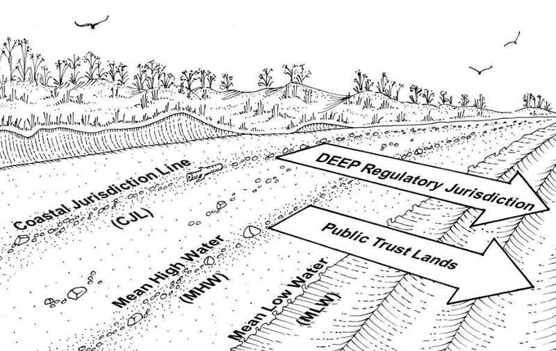 | | Coastal Jurisdiction Line |
Because the structures, dredging, and fill statute provided several methods of field-determining the jurisdictional high tide line, there were occasional disputes and even litigation over the extent of OLISP's regulatory jurisdiction (see the next article regarding an OLISP enforcement action in Stamford). Therefore, effective October 1, 2012, the "high tide line" is changed to "coastal jurisdiction line" (CJL), which is a fixed elevation that can be derived by a surveyor in accordance with a specified methodology. It is expected that future coastal permit jurisdictional determinations will be greatly simplified and streamlined as a result of this measure. The CJL was developed in cooperation with the Connecticut Association of Land Surveyors (CALS) to roughly approximate the location of the high tide line that OLISP had been using, and will be adjusted to reflect sea level rise upon the promulgation of tidal data from the next tidal epoch. OLISP has published a set of CJL elevations for each coastal town, with an explanation by CALS of the statutory methodology.
New Policies Relating to Sea Level Rise
For the first time, the concept of sea level rise was incorporated into the Connecticut Coastal Management Act's (CCMA) general goals and policies of coastal planning. Now, state agencies and coastal municipalities can consider the potential impact of a rise in sea level, coastal flooding, and erosion patterns on coastal development in order to minimize damage to and destruction of life and property and minimize the necessity of public expenditure and shoreline armoring to protect future new development from such hazards.
Revised Policies Regarding Shoreline Flood and Erosion Control Structures
The CCMA contains a number of strong policies encouraging the protection of natural shoreline sedimentation and erosion processes, and discouraging shoreline flood and erosion control structures (also known as "hard" structures or shoreline armoring, such as seawalls, bulkheads and revetments) except in certain specified conditions. Public Act 12-101 modified and explained several of these policies. In particular, houses built after 1980 but before 1995, and cemeteries were added to the list of uses for which erosion control structures may be authorized.
Further, two terms which have been integral to the interpretation of CCMA's flood and erosion control structure policies were defined and expanded for the first time. The definitions of the terms "feasible, less environmentally damaging alternative" and "reasonable mitigation measures and techniques" offer, in effect, a hierarchy or checklist of considerations that must be satisfied before a flood and erosion control structure can be authorized to protect one of the listed uses. Feasible alternatives include:
- Moving a house landward, away from floodwaters and wave action;
- Elevating the house vertically, preferably to the highest practical freeboard, at least as high as Federal Emergency Management Agency standards require;
- Restoration or creation of a dune or vegetated slope between the house and the water to absorb storm waves and protect against erosion; and
- Creation of a "living shoreline," which involves the restoration of other waterfront habitats.
Mitigation measures include:
- Establishment of a structure setback or rolling easement to allow upland migration of tidal wetlands to colonize upland areas as sea level rises;
- Beach re-nourishment to replace the sand supply that may be adversely affected by a seawall or groin; and
- Compensation for the hardening of one part of the shoreline by removing the equivalent extent of hard structures from another part of the applicant's site or from another site (i.e., "No-Net-Increase in Shoreline Armoring").
Changes in Procedures for Regulating Shoreline Flood and Erosion Control Structures
Both DEEP Office of Long Island Sound Programs (OLISP) through its coastal regulatory programs, and municipal land use authorities through the coastal site plan review process, regulate shoreline flood and erosion control structures and must implement the substantive policies of the CCMA. PA 12-101 made several adjustments to the regulatory process for such structures, beginning with a clarification of standards for denial of an application. The language simply requires the regulatory body to suggest the "feasible alternatives" or "reasonable mitigation measures" identified above for any flood and erosion control structure applications which are denied outright based on coastal management considerations.
Other new procedural provisions of PA 12-101 also apply to municipal land use agencies. One provision simply states that an application must be approved if the commission finds, based on the record, that it meets the statutory criteria for approval, and the use proposed to be protected is fundamental to the site's habitability or primary use. For municipalities that have been properly implementing existing procedures contained in Section 22a-109, this should be business as usual.
Moreover, PA 12-101 also exempts "any activity, including living shorelines projects, for which the primary purpose or effect is the restoration or enhancement of tidal wetlands, beaches, dunes or intertidal flats" from the definition of "shoreline flood and erosion control structure." These coastal resource enhancement projects therefore are not subject to the additional municipal procedural requirements that apply to coastal flood and erosion control structures (i.e., mandatory coastal site plan review and referral to OLISP) so as to encourage waterfront property owners to prioritize resource restoration projects over structural solutions.
Pilot Programs and Other Provisions
Finally, PA 12-101 contains a number of other provisions relating to sea level rise and adaptation to climate change. These include:
- A requirement that future revisions to the State Plan of Conservation and Development consider risks associated with coastal erosion caused by sea level rise, evaluate the impacts of such erosion on infrastructure and natural resources, and make recommendations for future development and infrastructure siting to minimize the use of erosion-prone areas.
- Authorization for DEEP to establish a pilot program to encourage innovative and low-impact approaches to shoreline protection, including living shorelines techniques, within available appropriations. While no funds have yet been appropriated, the Department may select certain projects for expedited regulatory approval.
- Authorization for DEEP, in cooperation with other partners, to seek funds for a shoreline management study to enhance the resilience of coastal communities in the face of coastal storm hazards and sea level rise.
- Authorization for UConn and the CT State University System to develop the science and engineering capacity to support planning and management to enhance the resilience of coastal communities in the face of coastal storm hazards and sea level rise, within available appropriations. Again, no funds have yet been appropriated for this purpose.
For more detailed information about these new provisions, please refer to our PA 12-101 Fact Sheet.
Return to Table of Contents
|
|
|
|

Inside |
|
Sound Tips:
Avoid Headaches
(and Law Suits)!
Check the location of the Coastal Jurisdiction Line BEFORE You Do Work on Waterfront Property
In the aftermath of major storm events like Tropical Storm Irene and in the face of sea level rise, shoreline residents are increasingly concerned about the impacts of flooding and erosion on their property. However, many waterfront property owners simply are not aware that work seaward of the coastal jurisdiction line (CJL) in the tidal, coastal or navigable waters of the state and in tidal wetlands is regulated by the state. To avoid damage to valuable coastal resources, as well as potential legal liability, it is important to follow the appropriate legal procedures before considering construction of a flood and erosion control structure. If your property borders Long Island Sound or any of the state's coastal rivers or creeks, be sure to check the location of the CJL and/or tidal wetlands before you conduct any work at the water's edge.
"Work" means, among other things, building, repairing, or replacing any structure such as seawalls, rock slopes, piers, floats, ramps, and walkways that are located in or over tidal wetland vegetation, or that extend seaward of the CJL.
Please do not assume that if a structure has been in place for many years it can be repaired, replaced, or modified without approval. This is not necessarily the case.
Many types of in-water work require authorizations that range from abbreviated permit processes like general permits and Certificates of Permission to full individual permits.
The abbreviated process may be appropriate to repair, replace, or slightly modify your existing structure, or to conduct maintenance dredging of areas that were dredged under previous authorization.
Any new structures, dredging, or filling would likely need a full individual permit, but small residential docks may be eligible for authorization under a general permit.
For more information about Connecticut's Coastal Permit Program, please contact the Office of Long Island Sound Programs Coastal Permitting and Enforcement Section.
We strongly encourage you to contact us to discuss what work you would like to do on your property. Most often, a pre-application meeting is the best way to determine if your project is approvable and what type of authorization is necessary.
Preparing an application and waiting a little while for the processing of the application is so much easier than cleaning up the environmental and financial damage from a violation.
|
|
View past issues of
Sound Outlook
|
|
Subscribe to Sound Outlook
or any other DEEP newsletter
|
Look Out For
Upcoming Events!
Long Island Sound Study (LISS) Committee Meetings
Please be sure to check the Calendar of Events on
DEEP's website
November: Harbor seals arrive in LIS from northern New England; winter flounder move into shallower water
December: Bald eagles return to Connecticut for the winter. For eagle viewing at
Shepaug Dam Bald Eagle Observation Area,
Southbury, CT,
call 1-800-368-8954
after Dec. 7 to register.
|
|
|
|
OLISP Enforcement Action in Stamford
Upheld by Connecticut Supreme Court
Coastal bluffs are critical coastal resources in Connecticut. Although they provide valuable wildlife habitat, one of the most vital functions that coastal bluffs perform is to buffer against flooding and coastal storms by absorbing wave energy. This function makes coastal bluffs particularly prone to erosion, but that eroded material provides a much-needed sediment source for beaches and dunes. Connecticut's coastal management program contains policies that are designed to protect coastal bluffs and the crucial roles they play. It's important to strike a delicate balance between protecting bluffs from activities that can quickly erode them while also recognizing that some slow, occasional erosion is necessary to provide a source of sediment. Shippan Point in Stamford boasts some of Connecticut's most beautiful coastal bluffs. Atop these "sea cliffs" sit idyllic waterfront homes on properties with some of the most majestic views of Long Island Sound. However, just below these picturesque landscapes and neatly manicured lawns, the bluffs' shoreline is in constant change. The waters of Long Island Sound wash against the toe of the bluffs everyday on incoming tides and slowly erode the coastal headland, much to the chagrin of the property owners who reside at the top of the slope.  | Coastal bluff with unauthorized seawall, Shippan Point
Photo Credit: Civil Air Patrol
|
One such property owner on Shippan Point hoped to prevent erosion of his bluff by constructing a 160-footlong seawall along his property's shoreline. Prior to constructing the seawall, the property owner had been informed by Office of Long Island Sound Programs (OLISP) staff that installation of a seawall at the toe of the slope of the bluff on his property would be in the state's coastal regulatory jurisdiction and would need a state permit as well as local coastal site plan approval. He was also advised that the proposed seawall would likely be inconsistent with coastal management policies that protect bluffs, and was strongly encouraged to pursue non-structural solutions to potential erosion problems such as vegetating the face of the slope. OLISP's assessment was based on almost 20 years of field expertise in identifying the "high tide line" which, at the time, was the limit of the state's coastal regulatory jurisdiction. The high tide line represented the maximum height reached during the year by a rising tide, and projects proposed at or seaward of the high tide line required state authorization. Municipal approval for seawalls and other types of shoreline flood and erosion control structures, especially those proposed landward of the high tide line, had also been mandated since 1987.  | Unauthorized seawall
under construction
Shippan Point, Stamford
Photo Credit: DEEP OLISP |
In spite of OLISP's advice, the property owner proceeded with construction of a massive seawall on his property and neither sought nor received state and local authorizations for the seawall. Ironically, tremendous amounts of earth were moved to prepare the site for construction of the seawall supposedly designed to protect against erosion, and huge stones--several tons each--were used to build the wall.On January 29, 2007, OLISP issued an order to the property owner requiring him to remove the unauthorized seawall. The property owner appealed the removal order through an administrative process at DEEP, and then appealed to Connecticut Superior Court when the removal order was upheld. When the Superior Court also upheld the removal order, he took his case to the Connecticut Supreme Court.
The property owner's main arguments in the Supreme Court case (Shanahan v. Dept of Environmental Protection, 305 Conn. 681 (2012)) were that OLISP was unfair and unreasonable in its issuance of the removal order, that the state had no right to order removal of the seawall since the work was conducted landward of the high tide line and therefore wasn't in the state's regulatory jurisdiction, and that the statute that defined the high tide line was constitutionally vague.
 | Unauthorized seawall at high tide
Photo Credit: DEEP OLISP |
In its decision issued on July 24, 2012, the Supreme Court upheld the removal order, rejected the property owner's challenge to the state's jurisdiction, and found that the enforcement action was neither unfair nor unreasonable. In fact, the decision called-out the property owner's "knowing and egregious disregard of environmental regulations" and posited that, "(h)ad the plaintiff's project complied with planning and review requirements at any point, he would not have proceeded in such a destructive and incautious manner." While the Supreme Court also found that the structures, dredging, and fill statute defining the high tide line was not constitutionally vague, OLISP had long acknowledged the limitations and potential confusion in implementing the statute because it allowed a number of methods by which to determine the high tide line. Cases such as this illuminated the need for more consistent and specific regulatory boundaries. The changes in state coastal permitting jurisdiction brought about by PA 12-101 now establish the "Coastal Jurisdiction Line" (CJL) which determines the regulatory line based on specific criteria and removes other factors that can affect the reach of water elevations such as wind, waves, and barometric pressure. Also, DEEP worked with the Connecticut Association of Land Surveyors to extrapolate the data and can now provide a CJL elevation for each coastal community. With the help of a surveyor, applicants and their consultants can now design their waterfront projects knowing specifically where the regulatory line falls on their property. Likewise, this approach enables DEEP staff to focus resources on reviewing the potential impacts of projects rather than analyzing the reach of the water on a property just to determine the regulatory limit. Return to Table of Contents
|
|
 |
War of 1812 Update: Connecticut's Long Island Sound War
As mentioned in the June 2012 issue of Sound Outlook, there was a lot going on in Long Island Sound 200 years ago in terms of maritime commerce, naval activity, and other water-dependent uses that still concern us today, albeit in a very different context!
 | U.S Naval Hero Stephen Decatur
Image Credit: New London County Historical Society |
Most notably, the heavy American frigate United States, under the command of dashing naval hero Stephen Decatur, captured the British frigate Macedonian in the open Atlantic Ocean on October 25. After repairing his damaged prize, Decatur brought the two ships safely back to Long Island Sound on December 4. Coming on the heels of U.S.S. Constitution's unprecedented August 19 defeat of the British Guerrière, this second head-to-head victory over the vaunted Royal Navy was simply over the top, causing great dismay in England and delirious glee in New England. Leaving the Macedonian's prisoners in Newport, the frigates and their crews met a triumphal reception in New London, where Decatur--no slouch in the P.R. department--quickly sent one of his midshipmen to deliver the news post-haste to Washington, DC. The young officer, whose father just happened to be the Secretary of the Navy, fortuitously arrived at the very moment of a grand ball at the White House held to celebrate Constitution's triumph. In a dramatic gesture that could not have been better scripted by Hollywood, the travel-worn midshipman knelt to lay the Macedonian's captured colors at the feet of First Lady Dolley Madison. In the meantime, the United States and Macedonian continued their celebratory journey up the Sound, arriving in New York City on New Year's Day 1813.
 | HMS Macedonian versus USS United States
By Thomas Birch
Image Credit: New London County
Historical Society |
In addition to the regular navy, private enterprise also played a part in the War of 1812 on Long Island Sound. While Connecticut was not a hotbed of privateering such as Baltimore or Salem, several Nutmeg State entrepreneurs built, fitted out, or captained privateers that sailed from Long Island Sound in the latter half of 1812 to prey upon British commerce. Perhaps the most effective of these was the schooner Mars of New London, whose captain was 59-year-old Revolutionary War veteran Charles Bulkeley.
For information on other War of 1812 Bicentennial events and activities, see the website www.ourflagwasstillthere.org, and be sure to read future issues of Sound Outlook through 2014.
Return to Table of Contents
|
|
|
SPOTLIGHTED COASTAL ACCESS:
City of Groton Secures Public Access to
Baker Cove through Coastal Site Plan Review
One of the cornerstones of Connecticut's coastal management program is promoting water-dependent uses of waterfront sites. The Connecticut Coastal Management Act (CCMA) defines "water-dependent uses" as land uses that require direct access to coastal waters in order to function, including, but not
 | Overlook of Baker Cove
at Calf Pasture, Groton
Photo Credit: Connecticut Coastal
Access Guide
|
limited to, marinas, commercial fishing operations, water-borne transportation facilities, and uses which provide general public access to marine or tidal waters. Such public access uses, and the facilities that support them, might include a place for the public to fish or launch a kayak, an observation deck to watch salt marsh birds stalk their prey, or an urban waterfront seating area for viewing cargo ships leave port. The CCMA requires that municipal land use authorities give highest priority and preference to water-dependent uses at waterfront sites. Therefore, when reviewing proposals at waterfront sites, municipal land use boards or commissions must determine whether or not the site can accommodate a water-dependent use. In situations where site constraints won't allow the development of an active water-dependent use such as a marina or a commercial fishing operation, the site might be suitable for providing meaningful opportunities for the public to access the site's waterfront for recreational use.  | Calf Pasture Overlook, Groton
Photo Credit: Connecticut Coastal
Access Guide
|
Such was the case in 2008 when the City of Groton's Planning and Zoning Commission permitted a non-water-dependent residential subdivision on Baker Cove in the City's southeast section near the Groton-New London Airport. Baker Cove is a shallow water embayment in Fishers Island Sound fringed by salt marsh and surrounded by a diversity of upland uses running the gamut from parkland to manufacturing. The owner of the 9-acre waterfront estate originally proposed a 12-lot residential subdivision without any provision for public access to the site's shoreline. Given that the site was not appropriate for a more active water-dependent use such as a marina, the Commission was able to lawfully approve the proposed subdivision after the application was modified to include a small waterfront park, complete with parking, picnic facilities, bike racks, and benches. The site also provides terrific views of Baker Cove and limited car-top boating launching opportunities for intrepid boaters willing to risk timing of their launch and return with tides (the Cove contains extensive intertidal mudflats!). The site, called Calf Pasture Overlook, was transferred from the site developer to the City of Groton who will manage and maintain it. Calf Pasture Overlook is a testament to the City of Groton's Planning and Zoning Commission and staff who carefully considered the public's interest in this waterfront site, as required by the CCMA, and who effectively worked with a responsible site developer willing to modify the original coastal site plan's design to provide a water-dependent use. The result has accommodated public access to the waters of Fishers Island Sound and has created a valuable community asset. For more information on this site and approximately 300 other places open to the public on Connecticut's coastal waters, please visit the Connecticut Coastal Access Guide.
|
|
Connecticut's New Fertilizer Law:
Keeping the Green on the Ground and the Blue in the Sound
In the Long Island Sound community we have a saying: If it goes on the ground, it goes in the Sound. 
This simple motto reminds us that rainfall runs across the surface of the ground, picking up pollutants on its way to lakes, streams, rivers, and, ultimately, Long Island Sound. So we need to be very careful about what we put on the ground. When it comes to caring for our yards and lawns, we purposely put materials like fertilizer and compost on the ground to keep lawns green, keep shrubs and trees healthy, and help these plants grow. Farmers also need to apply nutrients back into the soil to feed their crops. However, if more fertilizer and nutrients are applied to the land than what the plants can absorb, then those unused nutrients can be washed into our rivers and streams or seep into ground water when it rains. This overabundance of nutrients can cause an overgrowth of algae in our streams, lakes, and the Sound, and can potentially trigger toxic blue-green algal blooms or cause hypoxia, a lack of dissolved oxygen in water that kills fish and aquatic organisms. In an effort to manage the amount of nutrients introduced to Connecticut's waters, the Connecticut Legislature passed a new fertilizer law, Public Act 12-155, An Act Concerning Phosphorous Reduction in State Waters, which takes effect January 1, 2013. The law, in part, calls for CT DEEP to develop a statewide strategy to reduce phosphorous in inland, non-tidal waters. The law also pinpoints reductions in several specific municipal sewage treatment plant discharges. From a nonpoint source pollution perspective, the new law establishes restrictions on the use of fertilizer, soil amendments, or compost containing phosphate on lawns:
- It prohibits the application of fertilizer, soil amendment, or compost containing more that 0.67% phosphate to established lawns, except when a soil test determines the soil is lacking in phosphorous or if it is for establishing new grass or lawn repair.
- It establishes a seasonal moratorium on applying these products (from December 1st to March 15th). Why? Because grasses and other plants become dormant during the winter months and do not absorb nutrients which would be washed away by winter rains and snow melt.
- It prohibits application of these products within 15 feet of any brook, stream, river, lake, pond, sound, or any other body of water. Why? Because this distance prevents any overspray of fertilizer and chemicals from directly getting into surface water, and enables the plants in that buffer area to retain the excess nutrients so they don't get washed into the water body.
- It prohibits the application of these soil amendments to impervious surfaces such as concrete sidewalks and paved roads and driveways. Why? Because fertilizer that is applied to hard surfaces gets washed off by stormwater and flows into storm drains or into nearby waterways, quickly introducing nutrients to aquatic plants.
The new law exempts agricultural lands and golf courses from these requirements and allows the application of these products to lawns if they contain 0.67% or less phosphate.
Please refer to the summary of PA 12-155 for more specific information.
As a complement to PA 12-155, the Northeast Organic Farming Association (NOFA) of Connecticut recently received a Long Island Sound Futures Fund grant to develop an "Organic Lawn Care Certificate Program" in which lawn care technicians, small lawn care companies, and municipal workers who maintain lawns and landscapes can receive training in organic lawn care. The program will produce an Organic Lawn Care (OLC) Manual and will include a two-day educational course providing a focus on organic lawn care. It is expected that the certificate course will expand the number of certified organic lawn care providers and will result in a 35% reduction in nitrogen and phosphorous applications in Connecticut, thereby reducing nonpoint source nutrient pollution in the Long Island Sound watershed. The OLC course will also be packaged and offered to neighboring NOFA chapters in the Long Island Sound watershed with the hope of administering the course in their home states.
With these efforts to keep the green on the ground, we'll keep the blue in the Sound.
|
|
Climate Change Update:
Improving Municipal Responses to a Changing Climate
Have you noticed changes in weather patterns that have made you uneasy? For example, hot weather that leads to droughts, which in turn lead to wildfires in some areas, with increased rainfall and flooding in other areas? The federal government and the New England states have not only noticed, they have taken yet another step forward to get our region and communities better prepared to deal with these potential consequences associated with climate change.
In 2010, the Northeast Regional Ocean Council (NROC) and the Gulf of Maine Council on the Marine Environment (GOMC) conducted a climate change needs assessment for the region extending from the Bay of Fundy to Long Island Sound. A top priority was to stimulate innovation and increase the pace of municipal responses to a changing climate. Since the vast majority of land use decisions in this region are made at the local level, working directly with coastal municipalities on climate change adaptation is the most expedient way to make coasts more resilient and hazards-ready.
In 2011, as a follow-up to this climate change needs assessment, NROC, GOMC, the Marine Affairs Institute and Rhode Island Sea Grant Legal Program, StormSmart Coast Network, and Clean Air - Cool Planet are partnering on a two-year project funded by the NOAA Climate and Societal Interactions Program. The project has three main goals:
- Research and document best practice/innovative municipal adaptation approaches in the northeast and elsewhere;
- Provide municipal technical assistance to the New England coastal states; and
- Develop and disseminate adaptation/resiliency communications.
Work on the project is well underway, with the State of Connecticut playing a key part in that work. In fact, Connecticut was the only state to have two communities receive funding: Guilford for their community adaptation process, and Greenwich for their emergency response and land use planning.
In addition, OLISP is working with several coastal municipalities to employ some different strategies to cope with climate change impacts. In the wake of Tropical Storm Irene, many communities are prioritizing planning and action for preparedness. OLISP has partnered with UConn's Center for Land Use Education and Research and CT SeaGrant to work with communities to develop effective adaptation strategies. Workshops with Madison, Waterford, Westbrook, and Greenwich will soon be underway.  Further, efforts in the City of New Haven have been highlighted as a case study on the StormSmart Coast Network. Regulations and ordinances that New Haven has implemented to protect areas in that city most vulnerable to climate change can serve as models for other cities across the nation coping with similar threats. For more information on climate change, please contact Jennifer Pagach at 860-424-3295.
Return to Table of Contents
|
|
|
|
|
|
|


