Happy New Year! We sincerely hope you had a great 2011 and are looking forward to an even better 2012.
At Seattle Avionics, we're very happy because 2011 was our best year ever -- by far. Because of your support, in 2011 we dramatically increased our ChartData aviation data business, released the SkyPad 3, released new versions of Voyager for Windows, and released our long-awaited iPhone app -- Voyager FreeFlight for the iPhone. Thank you! And 2012 is shaping up to make 2011 look like a warm-up.
(Not incidentally, we're hiring software developers now. If you know your way around both a compiler and a plane, please send a resume and cover letter to
hr@seattleavionics.com)
We were especially busy during the last few weeks of the year so I want to explain what's new.
In particular, I want to introduce our exciting new iPhone app (Voyager FreeFlight for the iPhone) and I want to explain what's new with Voyager 4.5. And I want to update everyone about the FAA's proposed pricing changes.
Flight Log is a recurring newsletter for all Seattle Avionics customers, with the latest news, tips, and tricks. I'm very interested in your feedback, either to the newsletter or to any Seattle Avionics product. Please send any comments or suggestions to me directly at
SteveP@SeattleAvionics.com Back issues of Flight Log are available from our Web site at
http://www.seattleavionics.com/Newsletters
Voyager FreeFlight for the iPhone
Simply put, Voyager FreeFlight is the aviation app every pilot needs.
It's absolutely free, brilliantly easy to use, beautiful to look at, and astonishingly fast.
All-new FreeFlight is a completely fresh take on how to make an aviation app simple, elegant, and powerful. It draws on nearly a decade of experience making award-winning, powerful flight planning by offering you the first iPhone app with an auto-router that wind-optimizes your flight to get you there as fast as possible. Victor Airways, GPS Direct routing, Jet Airways - FreeFlight is ready for it all.
Using FreeFlight is simple because all major functions (Airport Information, Weather, and Flight Planning) are always just a tap away.
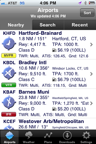
| Start Voyager FreeFlight and within about 3 seconds it finds the nearest airports and displays succinct weather and operational details about them -- without even tapping a button. |
|
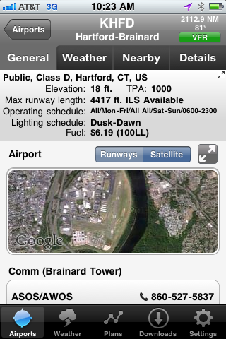
| Want more info about an airport? Tap the airport and all the details you need appears instantly -- without excess clutter. On the first airport page, you immediately see operational information, runways, navaids, and an embedded satellite map image of the airport. Want to call the local ATIS? Tap the phone number and your iPhone quickly connects you. |
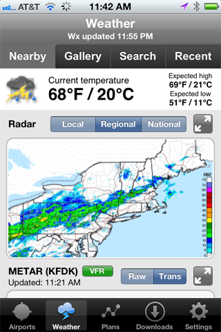
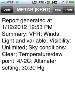
| Tap the Weather tab and FreeFlight uses your device's GPS to lock-on to your location and get the current temperature and sky conditions, a Nexrad radar image of the area, the nearest METARs and TAFs, winds-aloft, and even an official DUAT weather briefing. All with just one tap. Best of all for those of us who aren't 21 anymore, one tap zooms the METARs, TAFS, and weather graphics to full-screen, large font versions that anyone can read -- even in turbulence. |
|
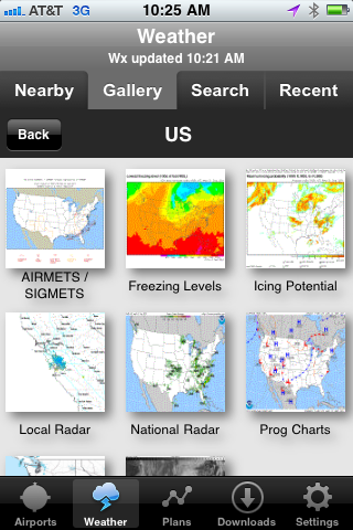
| Use the Gallery tab to view hundreds of US and Canadian weather graphics, many of which are animated. Quickly check the weather anywhere on the globe by entering an airport ident, city name, even a zip code. Of course FreeFlight keeps track of your recent selections for quick future access and stores graphics and METARs/TAFs on the phone so they're available even when you're not connected to the Internet (such as in flight). |
|
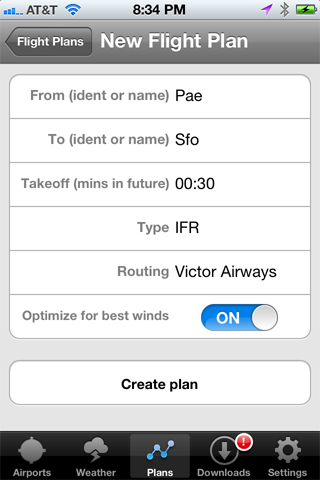
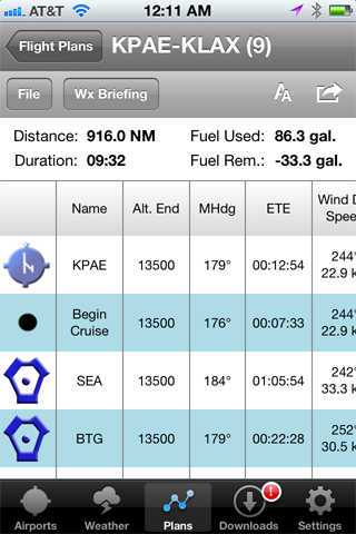
| No time to plan a flight? Give us 30 seconds and watch FreeFlight assemble the perfect wind-optimized flight plan between any two US airports. Tell FreeFlight where to depart, where to land, and how to fly there (Victor Airways, Jet Airways, or GPS Direct) and FreeFlight does the rest. FreeFlight even remembers your recent flights and home airport so you can often plan a flight by picking from a list of recently used airports rather than typing. |
| In just a few seconds, FreeFlight plots the whole course including all the navaids and intersections - not a simple straight line. It even uses the winds-aloft forecast to give you the ideal altitude for each leg of your trip. To make your life easier, FreeFlight automatically requests an official DUAT weather briefing so you're good to go. And since filing the flight plan takes one tap and about 3 seconds, it's easy and quick to fly safely. In fact, if you don't like entering flight plans into a GPS, FreeFlight wirelessly transmits the whole flight plan to the amazing Aspen Connected Panel for use in your Garmin GPS. |
Moving Map and Approach Plates
Seattle Avionics provides our ChartData to all the major iPad applications such as ForeFlight and WingX as well as aviation's elite avionics makers like Honeywell and Aspen. Therefore, FreeFlight does not include a moving map or approach plates. Rather, FreeFlight is the perfect "Do I want to fly today? How's the weather out there?" companion to these powerful apps.
Many of us have eyes that aren't quite so young anymore and may prefer text and images to be a little larger. FreeFlight has full-screen buttons and font-size buttons in several places to accommodate us.
 | In Weather, see a METAR or TAF full screen in a large font. |
 | In Plans, toggle between large and small fonts. |
| In Weather, see any weather graphic full screen. |
| In Airports, see the satellite image full-screen. |
| In Airports, see the text at the top full screen, large font. |
Installing FreeFlight to Your iPhone / iPad
Click here or use the App Store icon on your iPhone or iPad and search for "FreeFlight". This will install FreeFlight 1.0.1 which includes a few fixes for problems that some customers found in the initial 1.0 release (most notably a problem specific to Piper aircraft).
If you're installing FreeFlight on your iPad, understand that the app is designed for the iPhone's small screen although it runs fine on the iPad. That means it won't fill the entire iPad screen. You can make the app fill most of the iPad screen by tapping the "2x" button in the lower right corner of the screen.

Voyager 4.5 for Windows
I admit that it may seem like we've been quiet about Voyager for Windows. Actually we made several software releases during the past year but they were all designed specifically for the SkyPad. In late 2011, we rectified that by releasing Voyager 4.5 (technically 4.53) for Windows for all Voyager users.
Version 4.53 adds some new features, especially to do with in-cockpit use, and fixes a some bugs.
WebSynch with FreeFlight for the iPhone
If you're a Voyager for Windows or DUAT Voyager user, you're in for a real treat: FreeFlight for the iPhone is already pre-loaded with your aircraft and pilot profile as well as your recent flight plans. How? FreeFlight works seamlessly with the WebSynch feature built-into all versions of Voyager for Windows to share flight plans so it automatically picks-up anything you've saved with WebSynch.
If you use Voyager for Windows but have never used WebSynch, you'll love it because it lets you share flight plans between as many computers as you use. Simply fire-up Voyager for Windows or DUAT Voyager and select WebSynch from the File menu. We suggest that every Voyager user does this, especially those of you planning to use FreeFlight for the iPhone so FreeFlight will be ready to go when you launch it for the first time.
Easier to Use In-Flight
The most obvious new feature of 4.5 is that the bottom toolbar is now much larger. This makes it easier to hit the right button, especially while flying or when using a machine with a very high-resolution screen.
Tip: For machines like the Motion Computing LS800 or the Samsung Q1, there is a way to turn this feature off so more screen real estate is available. Select
Options from the
Tools menu, choose the
Preferences tab, uncheck
Use large buttons.

Similarly, especially when in GlassView mode, you'll notice buttons and text larger than before, making them easier to read and easier to click. You'll also notice a change in what happen when you click on the chart widget and how the
Cmd button works:
The concept behind the Command (
Cmd) button is that it tells the system that you want to do something special. Therefore, features normally hidden to save screen space would be shown. In the new version, it still works that way for some of the widgets (the Procedure widget, for example) but we toned-down what happens in Command-mode with the Chart widget. In previous versions, hitting Cmd showed a chart toolbar and altitude slider to the left of the chart. Neither is really necessary in GlassView as there is usually a larger toolbar above the Chart that's much easier to use in flight and you can change the altitude by tapping the status bar below the chart (the yellow one that starts with "Clouds >=12000 ft" in the screenshot above). This status bar is only visible when weather is displayed on the Chart. This isn't a limitation, however, since the only purpose of changing the altitude displayed on the Chart is to change the display of clouds or winds.
We also addressed the common problem of it being too easy to tap a point on the Chart and see an information box pop-up. In 4.5, you have to double-tap the Chart for more information.
There are also some subtle changes that aid in-flight use:
- The airplane symbol on the Chart is now better-looking and has a semi-transparent blue circle around it, making it easier to see against any type of chart.
- The Nearest widget (shows the closest airports) uses much taller rows that are easier to see and much easier to tap.
- Many buttons are larger, the ones on the Airport Info widget in particular.
- Much of the text uses a larger, easier to read font.
- METAR/TAF circles are now semi-transparent so you can see airports and navaids under them.
- Pinch to zoom is now more responsive.
Other Changes / Fixes
METARs/TAFs. In late December, the National Weather Service made a subtle change to the way they deliver TAFs and METARs. This caused a problem for the old version of Voyager. We fixed the problem for 4.53 but also dramatically accelerated the way TAFs were downloaded (in case you're curious, this was done by building off work we did for FreeFlight for the iPhone which downloads weather very, very fast). In 4.5, we also adapted to a small change to the NWS Winds Aloft data.
Better Printing. In some cases, Voyager had a problem printing airport information. We fixed that for 4.5. Voyager also had printing problems on some machines when the PC ran low on available memory. This was addressed in this release, especially for machines running the 64-bit version of Windows 7.
GPS Simulator. A great way to learn GlassView is to simulate flights with the GPS simulator. We made it a little easier to use in 4.5. For example, you can now click the red X in the corner to close it without the simulator stopping.
Flying Sideways. For a very small number of users, GlassView had a problem with the aircraft symbol appearing to fly sideways on the Chart. This one was a real head-scratcher for the development team as we knew it happened but could never reproduce it in the lab. This issue was finally found and fixed for 4.5.
Stability. We found and corrected a few cases where Voyager would become unresponsive under unusual circumstances.
Large Fonts. PCs generally can display text in normal or "Large Font" mode. With new PCs often coming with extremely high-resolution displays on small screens (that is, high DPI), many manufactures now ship their systems in "Large Font" mode so mere mortals can read the text. Voyager always adapted to such systems but considerable effort was put into 4.5 to do it better since the SkyPad3 is one of those high-DPI systems.
Tip: We changed the way scrolling works with touchscreen systems for the SkyPad 3. Some of you have written that this makes touch-scrolling more difficult for other systems. If this affects you, you can change a setting in Windows that will make things easier. Go to the Control Panel in Windows, select
Hardware and Sound, select
Pen and Touch, select
Panning, uncheck
Turn on Single Finger Panning. This will make Voyager work better but you will have to use two fingers to pan (scroll) in other applications.
FAA Price Increases
As many of you know, the FAA has proposed changing the way they distribute digital data -- Sectionals, Approach Plates, etc. In the past, this data was more-or-less free, allowing Seattle Avionics and other companies to build on what they developed and sell the value-added data product for a reasonable price. Now they plan to charge for this digital data because the number of people buying printed charts is dropping like the proverbial rock.
In November, I wrote that there was much concern and confusion over what exactly they were planning to do. On December 13, Seattle Avionics was at a meeting with the FAA and other companies in the industry to discuss the matter. The FAA presented their proposal and asked everyone in the room to comment. There were a lot of spirited comments when the pricing they announced was far more than most people expected. Luckily, it immediately became clear that they grossly underestimated the size of the iPad/tablet market so the final price will not be nearly so high as what was presented (and what was mentioned by some media outlets). You'll notice that I haven't mentioned a specific price because it's still very much up in the air and Seattle Avionics is working closely with our industry partners, AOPA, and the FAA to ensure the changes are reasonable. Nothing firm to report yet but we're not looking at the aviation equivalent of a nuclear winter -- although it may get a little chilly.
Upcoming Events
Seattle Avionics will be showing the SkyPad, FreeFlight for the iPhone, Voyager for Windows, and ChartData at the following upcoming events.
Stop by to say hello, see the latest features, play with a SkyPad or iPhone, or ask the experts any questions.
February 25 - 26, 2012. Northwest Aviation Conference & Tradeshow. Puyallup, WA.
March 27 - April 1, 2012. Sun 'n Fun. Lakeland, FL.
Until next time, happy flying.
- Steve Podradchik, CEO (and Editor)
SteveP@SeattleAvionics.com 
 Dear Fellow Pilot,