I've been waiting anxiously for a sneak peek at Jeffrey McMurtrie's redesigned Algonquin Map and I got the pleasure of speaking with Jeffrey the other day about all the work that he's put into this new version. I was happy to hear that not only was the map updated with tones of new and more accurate information but I was amazed to hear that he's redesigned the new map from the ground up. I can't even imagine how much work this has involved.
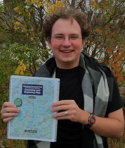 | | Jeffrey McMurtrie with his Algonquin Map book |
When I asked Jeffrey about the creation of his Algonquin Map he had this to say about it:
"The first thing that you should know (if it's not already clear,) is that I'm incredibly proud of my map of Algonquin Park. I've put over four years into it as of version three and don't plan on stopping... When it was time to begin the third revision of the map I decided to do something most wouldn't have even dreamt of - re-creating it from scratch. The most recent version - Version 3.0 - is now much easier to maintain and is more accurate than ever before. It took over a year and a half of consistent labour to complete, and I think that shows."
My conversations with Jeffrey started back when there were just rumors of a new Algonquin Map floating around. Since 2008 we have exchanged many emails and phone calls discussing the direction of the map. We've even sponsored the map development with purchases of digital data from the government that Jeffrey first used to start with.
Purchase a book or printed map at Algonquin Outfitters
I am happy to say that Algonquin Outfitters has already ordered over 100 copies of the map in book and printed formats. Hopefully having stock available by or shortly after November 1st 2010. We've heard the requests of customers to have more styles (book, map, etc) available at more of our stores and this year we hope to be able to stock most of our 10 stores with this wonderful new map. Even our Brent store, on the remote shores of Cedar lake, had a couple of maps this past summer. The best places to locate copies will be at the Algonquin Outfitters stores located in Huntsville and Oxtonge Lake.
GET YOUR FREE COPY
The best way to get your hands on a copy quickly (as long as you have a highspeed internet connection) is to download it right off of Jeffrey's website: www.algonquinmap.com, or *discover the hidden contest with in this posting and you could win a free copy of the V2 Map Book.
My Algonquin Map Review
I have to say at first glance there's a few obvious features that jump off of the page. The new map is easier on the eye with a much cleaner look and feel to it. Jeffrey has always tried to fill his map with as much detail and features as possible and the old version really felt like it had a lot of information on it. Although the new map has just as much and in many cases more information on it, now it doesn't feel like it's cluttered with information anymore. Every element has been resized, realigned and coloured to be much more pleasing to look at.
Old V2 Map vs New V3 Map
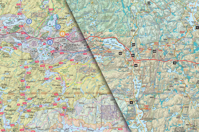 | | Click the above map for a larger image | | |
Simple things
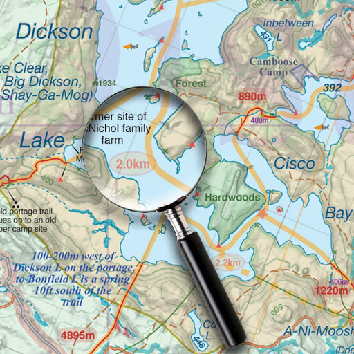
Things like making the access points and canoe routes markers simple black squares cleans things up a lot. I should also mention that although most Algonquin Park Maps list the traditional 29 access points Jeffrey's map goes on to list more than an additional 100 other suggested access points that include areas like the West side of Algonquin, the Big East River, Oxtongue River, Hollow River, Frost Centre, Gull River, Big East/Poker Lakes, Madawaska River, Bonnechere River, plus many more.
- Redone from scratch to be even more accurate
- Over $2000 invested in new data
- 75% of campsites now GPSed
- 50% of portages GPSed
- Portages whose lengths are significantly different than their signed lengths have both lengths labeled
- Changed visual importance of many symbols to reflect their importance
- More logical symbols
- Lake names that are not currently used universally have been marked as such
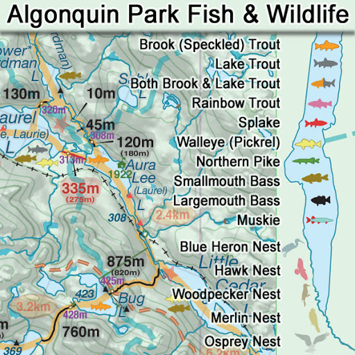
- Beaver dams
- Birds nests
- Intermittent streams now marked differently from other streams
- Lake labels now have halos to make them stand out
- Old lake names cleaned up
- Added two new canoe routes
- Canoe route distances labelled
- More logging roads and better accuracy
- More roads and better accuracy
- Road classifications better noted to distinguish between decent and poor roads
- Cleaner design
- Peak portage points and lake elevations are now computer calculated
- Contour lines changed from 10m to 20m to minimize the amount of area obscured
- Winter content split off on to a dedicated map
- Waterproof book available
- Dedicated backpacking map also available
- Fishing data totally redone
- Rainbow trout added
- Large bass added
- Muskellunge added
- Liftovers now shown
- Many more hiking trails added
- Hiking trails inventoried in legend
- More access points added
- Access points are better organized in the legend
- Each access point now has UTM co-ordinates for GPS use in the legend
- Notes now categorized by type
- Standardized typefaces across the map
- Proposed Ontario Parks Board protection zone changed to proposed Ontario Parks Board-Algonquin Forestry Authority joint protection zone
- Development, Wilderness and Natural Environment zones combined
- Hunting zones added for Algonquin park
- More accurate railway lines
- More accurate backpacking trails
- Cell phone towers shown
- Ruins differentiated from buildings
- Historic and old portages unified
- More historic canoe routes shown
- 'Bushwhacked' portage classification added
- Portages inside and outside of Algonquin Park are now labelled only by their maintenance level, not location
- Changed maintenance level of campsites and portages where appropriate
- Skippable portages as well as portages with high and low water entrances are better labeled
- Fixed error where ANSI zones were mislabeled
- Removed generic jumpoff campsite indicators
- Removed 'paddle in' campsite zones
- Removed clearings
- Removed sawmills
- Removed maintenance areas
- Removed tote roads and phone lines until better data is available
- Snowmobile trails combined with general trails
- More accurate and plentiful trails
- Lake index available
- Only major UTM grid lines labelled
- Map area no longer obscured by legend and access point list
- All labels now parallel to the bottom of the map
- Google Earth version will be available
- Huge number of errors corrected from my 2009 & 2010 canoe trips
- Index map much easier to use in the book
- Book now includes a 'how to use' section
- Neighboring pages are better labelled
|
* Comment on the photos showing details of the map above and you may win a copy of the Map Book.
|