|
UICDS™ keeps you better informed so you can make better decisions. UICDS is information sharing middleware for NIMS incident management that continuously receives and shares standardized data among many agencies during an incident. Your everyday application gets from UICDS exactly the data you need to use, visualize, process, improve, decide, and then share back through UICDS to keep everyone informed.
Because UICDS is middleware, there is no new user interface to learn, no cost to obtain it, and you retain complete control over your data. You get notified when an agency has provided new or updated incident data and you share your data with whom you want instantaneously and in the background without any disruption to your operation.
With UICDS you are better informed, your partners are better informed, and together you all make better response decisions.
|
|
Watch
UICDS The Movie

|
|
Get UICDS Free from the Department of Homeland Security
Apply to be a UICDS Pilot and get your own complete UICDS installation, including support, to improve your information sharing. Make your request now. |
Learn All About UICDS Interoperability Middleware in Just Two Minutes
Your time is valuable, so here it is in a nutshell.
UICDS is middleware to share information among applications used by all levels of government and critical infrastructure to manageincidents. UICDS has no end-user interface, so there is no training or new applications to buy.
You should care about UICDS if you manage emergencies or provide technologies to those who manage emergencies.
Click here for a two minute video introduction of UICDS from the UICDS.us website. |
Follow UICDS on LinkedIn
UICDS is now on LinkedIn, the premier business-related social networking site. The site is self-described as the "unofficial UICDS discussion group" among Technology Providers and End-Users. To join the discussion group,  |
| UICDS Contacts
General Information
uicds@dhs.gov
DHS S&T Program Manager Michael B. Smith Email Now DHS S&T Program Support Tomi` Finkle Email Now UICDS Project Manager Chip Mahoney Email Now UICDS Outreach Director James W. Morentz, Ph.D. Email Now |
|
UICDS™ is a Trademark of the U.S. Department of Homeland Security
|
|
|
|
UICDS Update
An Information Sharing Technology Program from the Department of Homeland Security Science and Technology Directorate
Special Issue - Year in Review
In this issue ...
|
 |
|
 Looking Back at 2011 and Wishing You Well for 2012 Looking Back at 2011 and Wishing You Well for 2012
This was a year of exceptional growth and accomplishment by many people using UICDS.
The UICDS middleware was proven to be solid, reliable, and innovative in many demonstrations and more than 30 pilots using dozens of UICDS Cores to share information all across the country among governments at all levels and critical infrastructure. An ever-increasing number of our new and experienced Technology Providers continued the growth of software integrated with UICDS to serve their state and local users. On the technical side, a robust new version 1.1.1 was deployed. Mobile apps for both Android® and Apple® were released in both downloadable apps and as example code for the UICDS development community to freely obtain and make their own. UICDS was integrated with IPAWS, the national warning system, and used in other important national programs.
And 2012 holds significant promise. Many of the 2011 UICDS Pilots will be "graduating" to operational status in the spring and summer. We have a backlog of pilot applications that we will be activating in the coming months to maintain the robust pilot program designed to employ UICDS in every conceivable operational setting so that we know it can meet the most demanding concepts of operations from a couple of rural agencies sharing incidents to a multi-state regional sharing network with critical infrastructure sensors, distributed resource management, public and private alerting, robust shared Common Operating Picture, and all the rest of the key incident management needs.
So, as you read the rest of this retrospective on what the emergency management community accomplished with UICDS in 2011, go to www.UICDS.us and click on the link to either "Apply to be a UICDS Pilot" or "Get the UICDS Development Kit" for Technology Providers. Your community and your Nation will be better served when you use UICDS in your daily and emergency operations.
--- All the best for 2012 from the UICDS Team
|
|
A Framework for Interoperability Tutorial and UICDS Biweekly Call on Thursday January 12
See a Preview of Upcoming Presentation to Transportation Research Board
John Contestible of the Johns Hopkins Applied Physics Laboratory explores why information sharing is important to successfully dealing with large scale events and how a lack of public safety communications systems interoperability is a major impediment. It describes how a conceptual framework of information layers (i.e. the Data, Integration and Presentation layers) is useful to developing solutions to the lack of interoperability. He further describes a concept of operations whereby Integration layer applications can form the core of a "Common Operating Picture" which can provide information to field personnel at the scene of an incident as well as the public. An inducement for jurisdictions to participate in such an information sharing framework is that they can gain access to wide array of information to which they would otherwise not be entitled and they can reduce the overall cost of such systems by sharing the infrastructure and system expenses across the regional partners.
To join the Framework for Interoperability call and our biweekly "open mic":
Call: 800-366-7242 and use code 735108 at noon ET.
Web Collaboration: Click here and scroll all the way to the bottom for the DataXchange collaboration.
Enter Conference Reference: 601203 Attendee PIN: 1143
Upcoming Presentation
January 26: Continuing the Discussion of Standards for Resource Management
Donald McGarry is a Senior Systems Engineer with the MITRE Corporation who supports MITRE's newly formed Federally Funded Research and Development Center for the Department of Homeland Security. In that capacity he has worked on the Emergency Response Domain data model and on showcasing the benefits of adoption of existing standards in the Emergency Response domain. Don is a voting member on the OASIS Emergency Management Technical Committee, Emergency Management Adoption Committee, and a number of subcommittees which have helped to drive the Emergency Data Exchange Language (EDXL) standards employed in UICDS. Don will be continuing our discussion of resource management through resource typing and resource schemas.
|
|
| Pandemic Decision-Support with UICDS: The University of Louisville Pilot
Robert Kelly of the University of Louisville is lead developer for the UICDS implementation in the Real-Time Decision Support System (RTDSS) for Healthcare and Public Health Sector Protection. The project is a collaboration among several universities in Kentucky and Missouri with the support of the National Institute for Hometown Security and DHS Directorate of Science and Technology. The goal of the project is to develop a decision support system to provide pandemic response staff with decision support tools to assist them with managing the response.
The RTDSS consists of three primary components, the
 | |
Information sharing flow for University of Louisville Pandemic Decision Support System using UICDS
|
Pandemic Decision Support System (PanDSS), a Unified Incident Command and Decision Support (UICDS) core, and third-party data sources. Complex interactions among hospital applications can be conducted through UICDS including multiple distributed applications that update a work product and notification services in which various systems are notified when changes to a work product have occurred.
Rob Kelley recently presented the results of this work to the First International Workshop on Healthcare Systems Engineering in Beijing, China.
The paper presented at the Healthcare Systems Engineering conference is available for you to review in advance of Rob's presentation by clicking here.
View the UICDS Biweekly Call and Tutorial to hear and learn all about UICDS and Pandemic Emergency Management.
|
|
New in 2011: Mobile Apps for UICDS for Android® and Apple®
UICDS Mobile Apps were a popular outcome of our development efforts in 2011. The Android app is available as described below and the Apple app is available on the Apple App Store (see next article).
But best of all, just as we have provided lots of example code for web application developers to download and make their own, we also have example code for both Android phones and Apple iPad and iPhone.
Download of the example code requires access credentials that were provided for those who have received the UICDS Core Development Kit. If you do not have credentials, you can request access by linking to either Request the UICDS Development Kit or Apply to be a UICDS Pilot, depending on your circumstance.
Among the features included in the first release of UICDS Mobile Apps for Android and Apple iOS are:
- Display list of Incidents
- Display list of Alerts
- Display text description (contained in a UICDS Work Product) of any Incident or Alert
- Display all Incidents or Alerts on a map
- Highlight an Incident or Alert shown on the map and see brief summary information in a pop-up box
- Display selected Incidents or Alerts on a map
- Display polygon graphics associated with a CAP Alert on the map
- Display Open Geospatial Consortium standard Web Mapping Service map overlays associated with an Incident on the map
Use your access credentials to download the Android Example Code or Android App directly to your Android phone.
Use you access credentials to download the iPad and iPhone App Example Code.
If you missed the live presentation on both Android and Apple UICDS Mobile Apps, you can tune into the UICDS Collaboration Portal (www.UICDS.us) at any time to hear these informative discussions. You can also directly View the Android Tutorial or View the iPad and iPhone Tutorial.
|
|
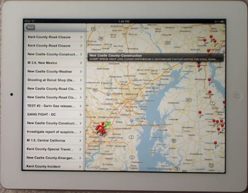
| Apple® App Store Approves UICDS Mobile App for Apple® iPad® and iPhone®
We are pleased to announce that Apple® has approved the UICDS Mobile App for distribution on the Apple App Store. The UICDS Mobile App is available immediately for download at no cost on the App Store.
The iPad and iPhone mobile apps are derived from the same example code which is available for download by registered UICDS Technology Providers. The mobile app, as seen in the illustration, provides the following capabilities: same example code which is available for download by registered UICDS Technology Providers. The mobile app, as seen in the illustration, provides the following capabilities:
- The base display is a map centered on your current location showing Incidents and Alerts
- Display list of Incidents and Alerts independently
- Highlight an Incident or Alert shown on the map
- Get brief summary information in a pop-up box and display full Work Product data
- Display polygon graphics associated with a CAP Alert on the map and OGC WMS overlays
Point your iPhone or iPad at the Apple App Store to download the UICDS Mobile App. |
|
Five-Minute Video Shows a Dozen Technologies Sharing Through UICDS
At the Second Annual National Capital Region Interoperability Conference conducted by the All Hazards Consortium (AHC), we showed examples of numerous technologies sharing through UICDS all across the region. In the NCR, several individual pilots are taking place. This demonstration showed how those pilots could be joined together through UICDS sharing agreements into a complete, region-wide sharing network.
The technologies shown were, sometimes, the actual
 | |
Demonstrating technology equivalents to operational systems using actual, but not current, data shared through UICDS
|
applications used in jurisdictions across the region. In other cases, because of restricted access to the operational technologies, we showed the technical equivalent of the operational system.
The video shows, in just five minutes, how effectively a net of information sharing can be created through UICDS.
So, take a look at this quick video to see data shared from:
- Three different Computer-Aided Dispatch
- Four different incident management applications
- Three different GIS viewers
- IPAWS national warning system from FEMA
- ALOHA chemical dispersion model from EPA
- Traffic cameras
View the video on the UICDS Collaboration Portal.
|
|
UICDS Pilot in Support of Palmetto Vision Project in South Carolina
One of the largest and most comprehensive UICDS Pilots is taking place as part of the Palmetto Vision statewide information management project in South Carolina. Sponsored by the South Carolina Emergency Management Division, Palmetto Vision will distribute to every county in the state an emergency management Common Operating Picture tool set. Information sharing among the counties is enabled by UICDS.
Phillip Armijo of Earth Technologies Integration, the prime
 | |
Palmetto Vision's ultimate goal is to provide a Common Operating Picture for each county and the entire state.
|
contractor, began the UICDS tutorial by describing Palmetto Vision as a "county-centric Emergency Management Common Operating Picture framework that provides consistent processes, tools, and data in order to more effectively plan and respond."
He continued by describing Palmetto Vision UICDS Core implementations that are currently deployed at nearly 30 counties with a total of 30 to roll out in the coming weeks. The overall project links instances of WebEOC, ESRI Flex Viewers, Google Earth, computer-aided dispatch, and the IPAWS alerting system in its first stage of deployment. Robert Zawarski then gave our online audience an overview of the technical details on how ETI has used the UICDS example code to integrate multiple applications as well as several innovations that have been developed and will be shared with other UICDS Pilots in the near future.  One key UICDS integration is with IPAWS. In South Carolina, only the state is the designated "warning point" that can issue IPAWS alerts. With UICDS, any county can now create a Common Alerting Protocol (CAP) alert in their local incident management application and immediately submit it through UICDS to South Carolina Emergency Management Division for consideration as an IPAWS alert. At the same time that this is occurring, the UICDS CAP Alert Work Product is shared with local subscribers, informing them that the IPAWS alert was submitted. One key UICDS integration is with IPAWS. In South Carolina, only the state is the designated "warning point" that can issue IPAWS alerts. With UICDS, any county can now create a Common Alerting Protocol (CAP) alert in their local incident management application and immediately submit it through UICDS to South Carolina Emergency Management Division for consideration as an IPAWS alert. At the same time that this is occurring, the UICDS CAP Alert Work Product is shared with local subscribers, informing them that the IPAWS alert was submitted.
Rob also talked about the other critical component of Palmetto Vision, WebEOC from ESI911. WebEOC is a statewide implementation throughout the counties of South Carolina. It is being used as the data repository for all the county emergency management agencies. Thus, it becomes the source of information to be shared through UICDS for situational awareness as displayed in the SC COP. You can tune into the UICDS Collaboration Portal at any time to hear this informative discussion. View the South Carolina Palmetto Vision Tutorial now. South Carolina Palmetto Vision and UICDS Featured at HIFLD Working Group The Homeland Infrastructure Foundation-Level Data (HIFLD) Working Group was established in February 2002 to address desired improvements in collection, processing, sharing, and protection of homeland infrastructure geospatial information across multiple levels of government and to develop a common foundation of homeland infrastructure data to be used for visualization and analysis on all classification domains. Maintaining this original purpose, the HIFLD Working Group has attracted a voluntary coalition of Federal, state, and local government organizations and supporting private industry partners who are involved with geospatial issues related to Homeland Defense (HD), Homeland Security (HLS), Emergency Preparedness and Response (EP&R), or Civil Support (CS). Within these broad mission areas, the HIFLD members and non-federal contributors are involved in a wide range of different functions including: Critical Infrastructure Protection (CIP), Crisis and Consequence Management, Intelligence and Threat Analysis, Antiterrorism/Force Protection (AT/FP), Defense Support to Civil Authorities (DSCA), Man-Made and Natural Hazard Modeling, and Government Facilities Management. Preparedness and Response (EP&R), or Civil Support (CS). Within these broad mission areas, the HIFLD members and non-federal contributors are involved in a wide range of different functions including: Critical Infrastructure Protection (CIP), Crisis and Consequence Management, Intelligence and Threat Analysis, Antiterrorism/Force Protection (AT/FP), Defense Support to Civil Authorities (DSCA), Man-Made and Natural Hazard Modeling, and Government Facilities Management. The Southeast Regional HIFLD Working Group recently held a webinar which featured an in-depth report on the Palmetto Vision use of UICDS. You can view the HIFLD webinar on Palmetto Vision. Note that the UICDS part of the webinar starts at 24 minutes.
|
|
| Common Operational Data: A New Way of Thinking in 2011 About Information Sharing Through UICDS
The Holy Grail of emergency information management is a common operational picture (COP). The problem with this goal is that each organization has a specific mission that is, by definition, unique to its role in an emergency. Thus, a COP that truly is useful to an organization will be specific - and thus, more than likely, an "uncommon operating picture."
Introducing this tutorial was Diane Vaughan, the GIS Manager for the California Emergency Management Agency. Diane has been engaged in balancing specific missions with geospatial visualization in her systems development. When she finished her first extended discussion on UICDS, Diane summed up the essence of UICDS when she called it "Common Operational Data."
 | |
Through UICDS, applications exchange incident decision-support data and with no additional effort any COP can consume and visualize Common Operational Data from UICDS
|
What Diane immediately recognized was that when standardized data is shared among multiple applications, then a COP visualization can be easily and inexpensively derived to support any organizational mission. Jim Morentz, UICDS Outreach Director, will describe the concept of Common Operational Data further and how UICDS makes the development of a COP completely viewer neutral.
UICDS pilots across the country have been demonstrating this across federal, state, and local governments as well as private-sector critical infrastructure and non-governmental volunteer organizations. The key lesson learned from the pilots is that UICDS information sharing succeeds in providing "common operational data" for emergency management decision-making - no matter how the data is visualized, whether in a detailed, mission-specific application or a general geospatial COP.
The phrase "common operational data" (COD) represents the universe of relevant incident data from which is configured the perfect COP for a specific organization. UICDS achieves COD because it delivers, first and foremost, ubiquitous information exchange among incident management technologies. UICDS creates many-to-many, incident-specific, agreement-based information sharing. By delivering this agency-to-agency incident knowledge to improve tactical decisions, UICDS manages the content in an incident repository to enable construction a COP for strategic monitoring and decisions. The UICDS COD assures that a distinctive operational mission can be supported by a distinctive COP by providing the same critical incident data in different views to support operations.
Important Resource Documents
Two important documents were discussed in the tutorial which support the idea of COD. The first was prepared by the Geospatial Management Office of the Department of Homeland Security. Common Operating Data (COD) Requirements for the National Response Plan (NRP) is the result of a study to identify the COD needs of each of the Emergency Support Functions. This is an excellent guide to what needs to be done to bridge between static base map data and dynamic, transactional incident data such as that which moves through UICDS.
The second document is the UICDS Data Exchange Workbook for UICDS v1.1.1. This is a tool for "identifying and prioritizing UICDS data exchange to achieve Common Operational Data." The guide walks you through the various UICDS Work Products and identifies all required and optional data entitites. It then provides a way to begin to define data exchanges by answering the question "Who has data to share?"
View the Common Operational Data Tutorial
|
|
| UICDS Demonstrates Interoperability with IPAWS, the National Warning System
CAP Messaging is Standard of Exchange
IPAWS is the Integrated Public Alert and Warning System that was established by Executive Order 13407 for the United States to have an effective, reliable, integrated, flexible, and comprehensive system to alert and warn the American people. FEMA is designated within the Department of Homeland Security to implement the policy along with its federal partners, the Federal Communications Commission, the National Oceanic and Atmospheric Administration's National Weather Service and the DHS Science and Technology Directorate.
The Common Alerting Protocol (CAP) is the data format selected by IPAWS to establish the national alerting standard. In 2008 UICDS selected CAP as the basis for the UICDS Alert Work Product, the atomic unit of information sharing for applications to share information about their alerts through UICDS. As a result, now that the latest version of IPAWS is currently operational, UICDS is introducing its interoperability with IPAWS. 
IPAWS also provides for messaging with the Emergency Data Exchange Language suite of standards. UICDS has implemented those as well and we will be conducting a separate demonstration on a call in the near future. One of our 2011 UICDS tutorials presented a real-time demonstration of CAP alerts distributed through IPAWS to UICDS applications and from UICDS applications to IPAWS and on to IPAWS destination alert disseminators. We were joined by - Buffalo Computer Graphics, Inc.
- CellCast Technologies, LLC
- Indiana University of Pennsylvania Research Institute
- ARDEC and the New Jersey Institute of Technology
Buffalo Computer Graphics, Inc. is the developer of DisasterLAN™, a NIMS-compliant web-based crisis management solution that has been designed for use in any emergency operation center. The system serves as a provider and consumer of messages sent through UICDS to IPAWS. DisasterLAN provides an easy-to-use web interface based on the workflow requirements of the emergency management community. Highly secure, and easy to use, it is used by numerous agencies at the state, county and local level, as well as by private organizations. CellCast EAGLE Alert messaging systems are used to deliver life-saving emergency alerts, post-disaster informational messages, public service messages concerning the location and availability of health care services (flu shots, etc.), prior to or during an outbreak, criminal activity alerts, and other important community interest. CellCast is actively participating in the roll-out of the Commercial Mobile Alerting System (CMAS) in the USA, including the completion of the first end-to-end CMAS pilot conducted in the State of Florida using cell broadcast. For the UICDS - IPAWS demonstration, CellCast will be sending all four kinds of CMAS messages through UICDS, all the way up to a Presidential Alert.
Indiana University of Pennsylvania Research Institute integrates UICDS and IPAWS through CIMS (Civil Support Team Information Management System) which has been specifically designed as a NIMS-compliant, all-hazard, tactical information system to manage CBRNE events through the provision of "digital battle board" capabilities. It provides the CST (Civil Support Team) with the ability to:
- share critical incident intelligence and data
- work collaboratively in a doctrine and standards-based environment
- monitor the completion of key team objectives
- accurately record the sequence of incident events
- report to supporting agencies and higher command in a quick and efficient manner
The New Jersey Institute of Technology UICDS-IPAWS effort is part of the Emergency Management and Business Continuity graduate degree program, a highly interdisciplinary degree designed to enhance critical skills and knowledge among private and public sector professionals working in the area of emergency management and business continuity. In the project, NJIT teamed with the U.S. Army Armament Research, Development and Engineering Center (ARDEC) to employ numerous tools related to the Common Alerting Protocol. In support of this UICDS - IPAWS demonstration, ARDEC create CAP messages using tools that NJIT developed during NLE 11 to form CAP alerts.
View the UICDS-IPAWS demonstration and tutorial on the UICDS Collaboration Portal.
|
|
| UICDS Best Practices on Blue Force Tracking
Blue Force Tracking - police, fire, emergency medical, National Guard, private utility vehicles, and even individual responder personnel - all these resources are rapidly acquiring geo-location capabilities that enable their location to be tracked by remote operations and command centers. Whether following a police car responding to a call for service or a truck fixing downed wires, knowing the GPS location of these key resources aids emergency operations management.
The UICDS approach to Blue Force Tracking is to enable the Open Geospatial Consortium (OGC) Sensor Observation Service (SOS) to track resources managed through the Emergency Data Exchange Language-Resource Messaging (EDXL-RM) standard.
Each entity (person, vehicle, etc.) tracked by a Blue Force Tracking system is submitted to UICDS as an EDXL-RM Commit Resource message which becomes a UICDS Work Product that is available to those who subscribe. The work product can give detailed information about each resource including a typing scheme (i.e. NIMS typing). The EDXL-RM Commit Resource Work Product is the static snap shot of the tracked resource such as when it was committed to the incident or at other key times. Tracking system is submitted to UICDS as an EDXL-RM Commit Resource message which becomes a UICDS Work Product that is available to those who subscribe. The work product can give detailed information about each resource including a typing scheme (i.e. NIMS typing). The EDXL-RM Commit Resource Work Product is the static snap shot of the tracked resource such as when it was committed to the incident or at other key times.
Associated with the Commit Resource Work Product is the Sensor Observation Information (SOI) Work Product. These sensor readings can include everything from chemical detections to biological samplings to radiological readings to video displays, and more - and in this case, GPS locations. The SOI work product provides periodic updates of resource state (Sensor Information data; in Blue Force Tracking this is location) along with a mechanism to obtain a real-time resource status.
In the first case of obtaining periodic readings, UICDS uses the SOI Work Product for those applications that do not need immediate and current sensor data. When a five-minute sampling of a sensor satisfies, or an every three minute location, the SOI Work Product is an efficient place to store such information.
But, where second-by-second sensor readings are needed SOS allows UICDS to provide all the detailed information needed for an application to directly access a sensor's web services. By accessing the sensors directly after receiving instructions from UICDS, the application can maintain the most current source information.
These two forms of sensor readings correspond to the UICDS design of detailed data (full access to sensor data) and fractional data (a portion of the detailed data, in Blue Force Tracking a location reading every few minutes).
All of this Blue Force Tracking Best Practice is contained in a document that will be discussed by Roger Wuerfel of the UICDS Team and Keith Pifko of Drakontas, Inc., the UICDS Technology Provider leading this tracking effort using their software, DragonForce.
|
|
UICDS Featured in Military-Civilian Interoperability Demonstration Video
 In 2011, new video was released by the Armament Research Development and Engineering Center (ARDEC) at Picatinny Arsenal in New Jersey showing the UICDS middleware as their key component to enable information sharing among homeland security technologies developed by both commercial organizations from civilian use and military applications. In 2011, new video was released by the Armament Research Development and Engineering Center (ARDEC) at Picatinny Arsenal in New Jersey showing the UICDS middleware as their key component to enable information sharing among homeland security technologies developed by both commercial organizations from civilian use and military applications.
- Eteam™ from NC4
- IRRIS™ from GeoDecisions
- WebEOC™ from ESI911
- ESA Portal™ from NC4
- ESRI COP™ from Environmental Systems Research Institute
- Google Earth™ from Google
- CPOF, Command Post of the Future from the Army Battle Command Systems
- FBCB2, Force XXI Battle Comand Brigade and Below from the Army Battle Command Systems
- WebPuff from the Chemical Stockpile Emergency Preparedness Program
- JSIF, Joint Situational Awareness Interoperability Framework from ARDEC
- RDDB, Resource Directory Database from the State of New Jersey
- iTeam, Information Technology for Emergency Management from Rutgers University Center for Information Management, Integration, and Connectivity
The demonstration displayed the effectiveness of using UICDS by allowing disparate emergency management applications to interoperate for:
- Multi-agency Common Operating Picture (COP)
- Resource Messaging
- Chemical Release
- Event Correlation
The demonstration video is now on the UICDS Collaboration Platform and may be reached by following this link:
|
|
UICDS Compliance Overview
What it means to "comply" with UICDS - An overview of UICDS Web Services and Data Exchange Standards
What does it means to "conform" with UICDS? In 2011, we conducted a tutorial for a manager who wants to tell his or her technical people what to do with UICDS.
While there is no formal compliance testing program for UICDS yet, this tutorial and the accompanying documentation can be used by a potential purchaser of incident management technology to specify what UICDS compliance means to their specific Request for Proposal.
The tutorial and documentation also can be used by Technology Providers to plan their integration efforts to achieve maximum match between their applications and the many forms of UICDS information sharing.
The tutorial covers:
- Required and Optional Web Services
- Data Elements in Work Products, Required and Optional
- Standards Employed in UICDS Data Exchanges
At the conclusion of the tutorial, and by using the documentation, you will be able to describe to your colleagues how you will be using UICDS to share information in a way that complies with the UICDS objective of two-way, one-to-many sharing.
View the UICDS Compliance Overview tutorial.
Download the UICDS Compliane Overview document from the UICDS Collaboration Portal.
|
|
UICDS Pilot in Richmond Features Intergraph® Computer-Aided Dispatch
One of the "early adopter" UICDS Technology Providers, Intergraph®, worked with their client, the City of Richmond, to make UICDS the center of information sharing between the Intergraph computer-aided dispatch used by Richmond and other Virginia organizations.
"The City of Richmond is excited to reach new heights in the world of mission critical information sharing across the emergency management and public safety domains. Richmond has enjoyed its partnership with Intergraph as evidenced by the outstanding and continued success of the External Alarm Interface Exchange project, which is now an American National Standard," said Bill Hobgood, Project Manager, City of Richmond. "With the UICDS project, we look forward to another joint success made possible by the Intergraph and SAIC team."
In making the announcement of the pilot, Intergraph said: "Intergraph is the first computer-aided dispatch (CAD) provider to implement a pilot interface for UICDS."
"Coordinated information-sharing is the key to critical incident response," said Patrick Esposito of Intergraph and the developer of EdgeFrontier which "acts as a bi-directional interface between the UICDS core and Intergraph's Computer-Aided Dispatch (CAD) system, monitoring incidents from each system and updating the other as necessary. We are proud to work with Intergraph and SAIC on this important project for the Richmond area."
"The City of Richmond and Intergraph have a successful history of partnering on standards-based interoperability initiatives," Intergraph reports. "Richmond's two-year pilot External Alarm Interface Exchange project, funded by the U.S. Department of Justice, automated the communications between alarm companies and public safety answering points (PSAPs) to reduce calls from residential and commercial security companies by approximately 6,000 annually."
"Intergraph places a high priority on driving industry standards that enable interoperability across agencies and jurisdictions," said John K. Graham, president, Intergraph Security, Government & Infrastructure. "Intergraph will continue to work with SAIC and the Department of Homeland Security to ensure our customers can support National Incident Management System (NIMS)-compliant interoperability. "
To view the Richmond Pilot Tutorial on the UICDS Collaboration Platform, click here.
|
|
2011 Sees Premiere of "UICDS The Movie" Featuring an Operator's View of How Applications Benefit from Data Sharing Through UICDS
UICDS The Movie is a short summary of UICDS featuring more than a dozen different applications that serve the needs of the emergency management community sharing information.
 | |
UICDS Tree of Incident Knowledge
|
This presentation of UICDS consists of a two-minute introduction to UICDS from the perspective of content - what information moves through UICDS and how it combines to provide what is needed to make collaborative decisions in an incident command or emergency operations center.
Then, more than a dozen different technologies are quickly described in their interactions with UICDS. You will see how UICDS delivers two-way, one-to-many collaboration among incident management applications beginning with dispatch, moving through resources, including geospatial data including effects of a chemical plume, and concluding with a common operating picture. All the different ways individual agencies look at information today - but with UICDS all those agencies are sharing standardized data so everyone has the current view of what is needed to resolve the problem.
- If you are an emergency management operator, this is your chance to see the UICDS Tree of Incident Knowledge grow before your eyes.
- If you are a UICDS Technology Provider - companies, governments, and universities - you will see how others have integrated their applications with UICDS.
UICDS The Movie is available in four different formats, depending on how you want to learn and use this video.
UICDS The Movie - Presentation Version: Click here to see the full-length (just 13 minutes, really) movie that shows how information moves through UICDS and how it combines to provide what is needed to make collaborative decisions in an incident command or emergency operations center. This movie format shows nothing by the screen and is especially designed for group viewing.
UICDS The Movie - Two-Minute Overview: The short summary of UICDS is available if you want to show someone the basic reasons and process of UICDS. This separate video is available on the UICDS.us home page (lower left) as well as by clicking here.
UICDS The Movie - Collaboration Version: More than a dozen different technologies are quickly described in their interactions with UICDS. In this version you get by clicking here you will be able to use the full capabilities of the UICDS Collaboration Platform to ask questions, make comments, and see the past discussion points of others.
UICDS The Movie - Chapter Version: Just click here to get UICDS The Movie without collaboration but still with the dynamic chapters that let you move around in the movie to see the exact technologies interacting with UICDS that what you want.
Four formats for your viewing pleasure ... UICDS The Movie. Check it out today.
|
|
UICDS in National Level Exercise for 2011
The National Level Exercise for 2011 (NLE 11) tested our Nation's ability to respond to and recover from a catastrophic incident impacting multiple states, all levels of government, and our communities and citizens. The scenario for this exercise was a catastrophic earthquake impacting the Central United States, specifically within the New Madrid Seismic Zone.
State-level departments and agencies from all eight states in the area participated, as well as Federal department and agency headquarters. The eight states that make up the New Madrid zone are Alabama, Arkansas, Illinois, Indiana, Kentucky, Mississippi, Missouri, and Tennessee. Additional participants will include other states, the international community, as well as several private sector and Non-Governmental Organizations.
In addition to actual participation in the exercise as a fully-engaged player or simulator, the exercise program includes tabletop exercises, self-directed exercises, and virtual participation.
To support these many forms of participation with the many different agencies and UICDS Technology Providers who may be supporting this national exercise, UICDS is established NLE 11 Hosted UICDS Cores to enable information sharing. These hosted cores were available to any agency or Technology Provider participating in UICDS for the purpose of establishing specific NLE 11 information sharing as determined by the participants.
Among the many participants, three UICDS Pilots offered their pilot connections with NLE 11 using the UICDS Hosted Cores.
 Dr. Michael Chumer of New Jersey Institute of Technology shows the network of sharing he created for the New Jersey Business Emergency Operations Center. At a high level, the UICDS-based part of the sharing net looks like the accompanying diagram. Dr. Michael Chumer of New Jersey Institute of Technology shows the network of sharing he created for the New Jersey Business Emergency Operations Center. At a high level, the UICDS-based part of the sharing net looks like the accompanying diagram.
Paul Seabury of ElanTech, Inc. ran their project in Kentucky supporting information sharing among law enforcement using both Web-based and Android mobile devices. This diagram shows how ElanTech will be supporting the communications portion of NLE 11. project in Kentucky supporting information sharing among law enforcement using both Web-based and Android mobile devices. This diagram shows how ElanTech will be supporting the communications portion of NLE 11.
 Andrew Schroeder of Direct Relief Andrew Schroeder of Direct Relief
International describes how UICDS was used to simulate selection of facilities with underserved populations in disaster areas and the commitment of donated medical and pharmaceutical supplies in the DRI deployment diagram shown here.
|
|
UICDS NLE 11 Technology Showcase Video Review
One of our most popular UICDS Tutorials and Biweekly Calls of 2011 focused on the UICDS NLE 11 Technology Showcase. Attendees heard about the participation of many applications (and you can hear about them still on the UICDS Collaboration Portal):
- ElanTech and Murray State University conducted the Kentucky Mobile Information Source Response during a simulated sharing of building collapse cell phone photos at Murray State University
- Draknotas' Blue Force Tracking during a simulated ammonia release into the air in Memphis and the response of police to the incident
- New Jersey Institute of Technology's Common Alerting Protocol message test and crisis information portal during a simulated support response by the New Jersey Business Emergency Operations Center
- The U.S. Army Armament Research, Development and Engineering Center, ARDEC, simulated multiple sources of NLE 11 incidents, converted significant CAP alerts into UICDS incidents, and served as an important UICDS Core host for multiple organizations
- Direct Relief International simulated delivery of donated medical and pharmaceutical supplies to clinics in the earthquake zone through sharing of EDXL-RM Resource Commits
- ICWater, an Environmental Protection Agency (EPA) water modeling capability, simulated releases of chemicals into both the Ohio and Mississippi Rivers
- EPA's ALOHA chemical air dispersion model simulated industrial accidents involving multiple chemicals
|
|
View From The Field - Thoughts On the UICDS NLE 11 Technology Showcase
Richard Wells of the Las Vegas Office of Emergency Management was one of many people who took advantage of our offer to observe the UICDS NLE 11 Technology Showcase through either Google Earth or the ESRI Flex Viewer. Below are excerpts from Richard's note to Joel Myhre who worked with the Direct Relief International UICDS Pilot in the Technology Showcase and Jim Morentz, UICDS Outreach Director:
"Hey Joel and Jim. Although I was not able to participate in the NLE 11 exercise I was able to login to the UICDS Flex Viewer and look around a bit. First off my thanks to both of you for affording the access to the flex viewer for the exercise - it gave me plenty of ideas and examples to illustrate to my Emergency Manager here at the city.
"Performance was the first thing that caught my attention - I found the drawing speeds and address lookup to be excellent...
"I was also both impressed and amazed at the presentation of the information from the UICDS incidents and alerts buttons. The Flex Viewer is the perfect presentation tool to use spatial content to illustrate what is going on and where. The call out boxes were very easy to read and to work around while zooming, panning etc. The content with embedded links and other key incident information was also very impressive.
"Having been challenged for years here at the local level to develop and implement a workflow with an end result like this has me very interested in the nuts and bolts that made all this come together. I have seen some good implementations of commercial incident management software in operation but nothing even close to this!
"Thanks to you Joel I have been able to tap into a few briefs on UICDS but still am very thin on the process and workflow etc. I am very much interested in learning more about it as far as how the information from the field, EOC and other locations were able to get synced up and presented in such an impressive format.
"That is some great work - I appreciate the exposure to it!!! Thank you both and your teams for making that possible!"
|
|
UICDS Case Studies of Successes in NLE11 Featured in National Exercise Lessons Learned Conference
UICDS was one of a select few technologies participating in NLE11 that presented case studies at the National Exercise Lessons Learned Conference in September.
One case study focused on an Overview of NLE 11 and UICDS participation with a number of different Technology Providers and several of the ongoing UICDS Pilots.
UICDS in the Cloud was the subject of the second case study, recounting the installation of UICDS in the Cloud and its operations throughout the exercise to demonstrate the scalability of UICDS to a national catastrophic event.
A detailed case history of the use of Modeling Results Shared Through UICDS constituted the third case study showing linkages to chemical air dispersion models, water contamination models, and their distribution to a number of technologies providing situational awareness.
|
|
ElanTech and Murray State University Talk about Their NLE 11 Experience
ElanTech's IMDSS software deployed in earthquake simulation at Kentucky's Murray State University
In a press release, ElanTech, Inc. described the successful deployment of its Incident Management Decision Support System (IMDSS) software during FEMA's National Level Exercise 2011 (NLE 11) disaster simulation conducted at Murray State University. The exercise involved participation by the Murray State University Police, Murray City Fire Department, Calloway County Fire Department local search, rescue and ambulance services, American Red Cross personnel and volunteer victims.
The key application in the exercise was IMDSS, a software tool that aggregates diverse information pertinent to the management of an emergency into one geospatially organized digital dashboard. During this simulation, IMDSS was fully exchanging information through UICDS. 
"For this exercise, IMDSS was used to create three events - a building collapse and fire, mass casualties and an equipment failure resulting in casualties," said James Gantt, director of the Center for Telecommunications Systems Management at Murray State University. "Event data was made available nationally to UICDS users participating in NLE 11."
IMDSS Mobile was also used to capture on-site photographs and other site data that was attached to the IMDSS events. The on-site information was automatically made available to UICDS users nationally.
"This simulation provided a robust and realistic demonstration of how IMDSS aggregates and visualizes disparate data for UICDS users locally and nationally," says Swati D. Allen at ElanTech. "We're very pleased with how well it performed in this complex, large-scale test."
|
|
UICDS Tools: Incidents, Mapping, Sharing
An incident from one application, a location from a GIS, and see the combination on another application
See the UICDS Tree of Incident Knowledge grow before your eyes.
The purpose of this mid-2011 tutorial was to illustrate some of our current UICDS Tools and example code. You saw how an incident created without a location, say from an RSS feed or an application, can be shared with a GIS application which adds its own special information to the incident. In this case, adds a location.
Then, when another application looks at the incident, it sees not just the incident but the incident and location.
Not only is information shared, it is improved by the composite of all applications, each sharing their specific data to form incident knowledge.
So see how the Tree of Incident Knowledge grows and how UICDS delivers two-way, one-to-many collaboration among incident management applications.
View the UICDS Incident and Map Sharing Tutorial.
|
|
| UICDS Tools: ESRI™ ArcGIS™ UICDS Adapter for Operational Applications and Example Code for Developers
You have your GIS with lots of data on it. And you have an incident. How do you share only the relevant information with all your responding forces? Responders do not want to know where all your sandbag resources are or every stream gauge reading. Rather, you want to give them the geospatial view that is useful to them and nothing more. The ESRI™ ArcGIS™ UICDS Adapter does exactly that.
UICDS Tools were introduced inn 2011 as applications that demonstrate the capabilities of UICDS and enhance our library of example code for developers. As we said on the introductory tutorial, these UICDS Tools are free, downloadable, and not intended to be long-term solutions to information management. Rather, they are small applications that illustrate a UICDS capability that should be incorporated into commercial, government, and academic emergency management applications.
The ESRI™ ArcGIS™ UICDS Adapter enables the following capabilities:
- Within ArcGIS desktop, a widget accesses the UICDS Incident Service and provides a list of all current incidents
- ArcGIS geospatial data near those incidents can be displayed from local sources or from remote web service-enabled sources
- Individual data items can be selected as relevant to an incident on ArcGIS
- The UICDS Adapter widget associates selected data with the UICDS incident
- The adapter publishes the selected geospatial data as part of the UICDS Map Work Product associated with the incident
- UICDS then notifies other applications that there is new geospatial data available and exactly the right information is shared to your emergency response partners
|
|
UICDS Tools: Handling Binary, Link, and Shapefile Sharing Through UICDS with Example Code
During a biweekly call and tutorial in early 2011 we introduced three tools that help to add information to the UICDS Tree of Incident Knowledge. UICDS Tools are part of a "starter kit" of application example code that all UICDS Technology Providers can access to speed their way to full UICDS conformance. The audio and video demonstration and discussion of the tools is available on the UICDS Collaboration Platform under UICDS Tools Binary, Link, Shapefile Tutorial. Three tools introduced in this tutorial are:
- Link and Binary Work Products Submitter used to associate links and binary files to an incident.
- Shapefile Submitter used to associate ESRI Shapefiles to an incident.
- Link/Binary/Shapefile (LBS) Viewer which reaches into the UICDS Core, identifies all the incidents that have link, binary, or Shapefiles associated with them, and then enables the viewing of those files through the appropriate program.
|
|
UICDS Tools: GeoRSS and RSS Injector
The UICDS Tutorial in February 2011 showed an application and example code for UICDS output via RSS (Really Simple Syndication) to provide a "feed" of data that can be subscribed to by an application. This allows point-to-point, application-to-application one-way delivery of data.
We also showed the common variant of the RSS feed, GeoRSS, which enables the channel to carry content that includes geographic locations, plus some related feature descriptions, that receiving applications can use to display on maps.
The UICDS Tool, RSS Injector, is designed to show adapter developers how to create adapters to ingest RSS and GeoRSS feeds. The reason for doing this in UICDS is to (a) create a one-to-many relationship for important feeds so that they are shared among UICDS applications without each application having to separately consume the feed and (b) to allow applications to select feeds to associate with an incident and select items from a feed to associate with an incident.
This UICDS Tool is intended to illustrate the capabilities of UICDS to ingest RSS and GeoRSS feeds; however, the most important role of the tool is to provide example code for developers to employ in their own applications and adapters.
View the demonstration and tutorial on the RSS Injector UICDS Tool on the UICDS Collaboration Portal.
Using your UICDS credentials, you can download the RSS Injector example code from the same site as your downloaded the UICDS Core. If you do not have access, go to www.UICDS.us and register either as a Technology Provider or a potential UICDS Pilot site (in the boxes at the bottom of the home page) and by answering a few questions we will get you login information.
|
|
In Search of a Resource Typing Schema: Part I
Aaron Lieb, U.S. Army Armament Research, Development and Engineering Center (ARDEC), one of the long-time participants in UICDS posed this question to the UICDS community: Where do we get a resource typing schema?
So we turned over one of the UICDS Tutorials and Biweekly Calls to Aaron who discussed why the development community is in need of a resource typing schema. And how to get it.
This is not the NIMS Resource Typing that is an on-going effort supported by DHS. That represents the content of resource names and types. Rather, Aaron talked about the need for a schema into which this content is placed in a computer format.
OASIS® and EDXL Examples
The examples coming from OASIS for using the Emergency Data Exchange Language-Resource Messaging (EDXL-RM) TypeStructure and TypeInformation element have largely had place holder information such as the type structure: urn:x-hazard:vocab:resourceTypes - which seems to be something used for the purpose of an example. The documentation from OASIS explains that the community of interest that wishes to share Resource information needs to come up with an agreed upon schema, which application interfaces on all sides of an information sharing exchange will be able to understand like an IPAWS COG, UICDS Core, or other message routers, etc.
Getting to This Point
In researching the schema, Aaron discovered an example of a resource typing schema that was developed as part of the FEMA IRIS resource system. From the IRIS User's Guide (see documentation below), Aaron derived a resource typing schema that he is offering as a starting point for discussion. Aaron's version is linked below.
The specification seems to capture the type of information that would be relevant for implementing NIMS typing through UICDS - making this structure a very strong candidate for standardizing how type information should be defined when constructing EDXL-RM messages (see linked document below).
Future Requirements
Aaron suggests that the UICDS community is one place that can participate in the ongoing discussion regarding resource typing schemas. Ultimately there will be an official stamp of approval through NIEM, OASIS, FEMA, or others, but until then, the UICDS community can contribute to the discussion. (See the next article for the discussion that emerged from our first resource typing schema tutorial.)
To read up on some of the issues about resource typing and to see the draft schema Aaron offered up for discussion, you may download the following documents:
View the Resource Typing and Schema Tutorial
|
|
Furthering the Search for a Resource Typing Schema: Part II
The Resource Typing Schema discussion noted in the previous article launched an active dialogue. In a subsequent tutorial we heard from two additional approaches to Resource Typing plus had an update from the previous call. Presenting their projects were:
- LTC Fritz Krauss, Ph.D., California National Guard, Director J5/7, will describe the Civil Support Task List (CSTL)
- David Blakeman and Charlene Duncans, Preparedness-Technology, Analysis, and Coordination (P-TAC) Center, will talk about the Incident Resource Inventory System (IRIS)
- Aaron Lieb, U.S. Army Armament Research, Development and Engineering Center (ARDEC) will update on lessons learned from the resource schema discussions of the previous UICDS call
Civil Support Task List
The Civil Support Task List is a collaborative effort from many states and agencies to generate a common taxonomy and lexicon that allows the military to reframe our existing warfighting capabilities into emergency response capabilities in a way consistent with the National Response Framework. Most agencies that are not primarily emergency response agencies either have or will face questions surrounding how to reframe what they do all the time and understand in their own vernacular into a useful capability that can be seamlessly integrated into a coordinated response under the direction of the Incident Commander.
The complexity for the CSTL was compounded by the different terms, references, policies and capabilities generated by the different armed services, but the success of the project is attributed directly to the willingness of most of the states and over 100 different agencies to meet in the middle and build the bridging structure to support the ability of the military to respond when needed with the right capabilities.
Incident Resource Inventory System
The Federal Emergency Management Agency (FEMA) National Preparedness Directorate (NPD) provides a "no cost" resource inventory tool. The Incident Resource Inventory System (IRIS) is developed and maintained by the Preparedness-Technology, Analysis, and Coordination (P-TAC) Center and allows response officials to enter typed and non-typed resources into a database and to search/identify specific resources for incident operations and mutual aid purposes.
IRIS features the capability for users to inventory resources and share resource information with other agencies. Furthermore, users are able to define non-typed resources and select specific resources for mutual aid purposes based upon mission requirements, the capability and availability of resources, and desired response times.
Exploring Best Practices in Cross Resource Typing Sharing Through a Common Schema
We had a very lively discussion led by Aaron Lieb of the U.S. Army Armament Research, Development and Engineering Center (ARDEC), on resource schemas. This led to some innovative thinking about how UICDS can help bring about cross-typing sharing of resource types through its schema. The concept is one in harmony with all the UICDS goals: establish a common exchange framework among disparate content. In this case, we explored the concept of creating a best practice for sharing resources of different typing structures by creating a mapping among typing structures. The idea has a long way to go, but once there is a consistent resource schema that references multiple resource typings, then the next logical step is to map across typing structures. The lessons provided by CSTL certainly speak to the possible success of this approach.
View the Resource Typing Discussion Tutorial
|
|
Cell-All Demonstration Includes UICDS as Connection to Incident Management Operations
UICDS was part of a 2011 demonstration of Cell-All, a Department of Homeland Security, Science and Technology Directorate (S&T) effort to equip cell phones with a sensor capable of detecting deadly chemicals at minimal cost. Combining the efforts of several companies and government agencies, the Cell-All project will embed sensor in cell phones in order to detect a problem and alert authorities automatically.
Detection, identification, and notification all take place in less than 60 seconds. Because the data are delivered digitally, Cell-All reduces the chance of human error. And by activating alerts from many people at once, Cell-All cleverly avoids the longstanding problem of false positives. less than 60 seconds. Because the data are delivered digitally, Cell-All reduces the chance of human error. And by activating alerts from many people at once, Cell-All cleverly avoids the longstanding problem of false positives.
 The role that UICDS played in the demonstration was to disseminate the alert information to incident management software that operations in emergency operations centers. In the demonstration, UICDS delivered notification of the Cell-All alert (originally a Common Alerting Protocol (CAP) message) to NC4's ETeam™ application software. The role that UICDS played in the demonstration was to disseminate the alert information to incident management software that operations in emergency operations centers. In the demonstration, UICDS delivered notification of the Cell-All alert (originally a Common Alerting Protocol (CAP) message) to NC4's ETeam™ application software.
The end result: emergency responders can get to the scene sooner and cover a larger area-essentially anywhere people are-casting a wider net than stationary sensors can.
In addition to NC4, three teams from Qualcomm, the National Aeronautics and Space Administration (NASA), and Synkera Technology worked together on the demonstration.
|
|
A Review and Analysis of Standards Used in UICDS
"SIMON and UICDS platforms are believed to represent a comprehensive collection of standards relevant to information gathering and sharing, as well as to interoperability."
Shane Mason and the team from SRI International (SRI) reported on their study of standards that included a look at UICDS. In the study, Shane reported, "We first present background information on the use and types of standards. Then, we describe both SIMON (Smart Integration Manager Ontologically Networked) and UICDS to create a basis of understanding for the use of standards in the development and design cycle of the two platforms."
The study was conducted as part of SRI's work on the Maritime Security Technology Pilot (MSTP) for the Department of Homeland Security (DHS) Science and Technology (S&T) Directorate. SRI analyzed the standards relationship between SIMON and UICDS. The study focused on 14 architectural standards, two schema types, and two transport protocols and their utility for emergency management information sharing.
In describing each platform, Shane said they "describe components, such as services, in detail to provide information about the use and incorporation of particular standards. We then present a use case describing potential integration between specific system instantiations of each platform as a basis for assessing the risk of such integration."
View the Standards Assessment Tutorial
|
|
|
Using UICDS in the Field: A Guide to Becoming a UICDS Pilot
This tutorial was conducted during the UICDS Biweekly Call on January 6 and it is now online at the UICDS Collaboration Platform. The tutorial provides everything you need to know about getting your own UICDS middleware deployed in the field as a UICDS Pilot. The session covers:
- How UICDS Works to Improve Incident Management
- What it Takes to Become a Pilot
- Costs, Timeline, and Schedule
- How Information is Controlled and Secured
- Technical Overview for Non-Technical People
- The UICDS Pilot Site Collaboration Portal
This is the one-stop-tutorial to help you decide if you want to join the cities, counties, and states across the country who are implementing UICDS at no cost through the DHS Science and Technology Directorate pilot program.
To see the tutorial, link to the UICDS in the Field Tutorial.
Supplement the Tutorial with a Look at UICDS in Real-Time Operations
The UICDS Pilot Tutorial online presentation should be supplemented with a short video that could have been called, Seven Minutes in the Life of UICDS. The video is a real-time capture with narration of what was happening on a Sunday afternoon in Richmond, Virginia ... live. The Richmond traffic data on real-time accidents is provided to a UICDS Core from which it is shared to other UICDS Cores and to a number of applications. This short video depicts what it looks like to share information through UICDS and is a great way to see the results of UICDS after going through the UICDS Pilot Tutorial.
|
|
Use the UICDS Development Kit To Win Contracts that Require UICDS Compliance
Recently, the State of California and the State of West Virginia both issued requests for proposals that called for UICDS compliance as a condition of the contract. Feeling left behind?
Now there is a guide to what it means to "comply" with UICDS. Get the new UICDS Compliance Overview report to see the details. And you can see and listen to the UICDS Compliance Tutorial about compliance with UICDS v 1.1.1 on the UICDS Collaboration Portal.
If this is you ... and you don't want to be excluded from future bids ... just answer a few questions to get the UICDS Development Kit and example code to build your UICDS Adapter today. Get started by clicking here.
|
|